- My Forums
- Tiger Rant
- LSU Recruiting
- SEC Rant
- Saints Talk
- Pelicans Talk
- More Sports Board
- Coaching Changes
- Fantasy Sports
- Golf Board
- Soccer Board
- O-T Lounge
- Tech Board
- Home/Garden Board
- Outdoor Board
- Health/Fitness Board
- Movie/TV Board
- Book Board
- Music Board
- Political Talk
- Money Talk
- Fark Board
- Gaming Board
- Travel Board
- Food/Drink Board
- Ticket Exchange
- TD Help Board
Customize My Forums- View All Forums
- Show Left Links
- Topic Sort Options
- Trending Topics
- Recent Topics
- Active Topics
Started By
Message
re: Severe Weather for Friday
Posted on 4/8/21 at 8:30 am to LightMerchant

Posted on 4/8/21 at 8:30 am to LightMerchant
[quote]“observation deck”. Lmao. Because “deck” is too pedestrian.[
This post was edited on 4/25/21 at 8:24 pm
 1
1

Posted on 4/8/21 at 8:56 am to arseinclarse
OP updated to reflect Friday’s event
Posted on 4/8/21 at 9:08 am to deltaland
quote:
OP updated to reflect Friday’s event
From the looks of that picture N.LA and Mississippi bout to get fricked.
Posted on 4/8/21 at 9:22 am to V Bainbridge
Potential is there but there could also be a cap to limit supercell development.
We will know more in 24 hours
We will know more in 24 hours
Posted on 4/8/21 at 9:32 am to WhuckFistle
quote:
Tornado warned cell headed towards Dardanelle and Russellville.
I drove through that on i40 going back to LR from NWA yesterday. Everyone pulled on the side of the interstate bc it was pretty close to us. A wee bit scary but I survived!
This post was edited on 4/8/21 at 9:33 am
Posted on 4/8/21 at 10:17 am to rt3
All people need to do is cancel school friday and it will go away.
Posted on 4/8/21 at 10:34 am to deltaland
quote:
Potential is there but there could also be a cap to limit supercell development.
When/if that cap breaks, those are going to be some really tall storms with potential for really big hail, particularly for East Texas. You don't see the "giant hail" wording very often in a general discussion.
Posted on 4/8/21 at 10:35 am to deltaland
Just heard that the house across the street from my grandmas in Marksville got struck by lightning and burned down. Shite got wild quick. Thankfully no one was injured. Goldfish Friday looking forecast will suck.

Posted on 4/8/21 at 10:53 am to deltaland
Gonna be a rough overnight here in Walker.
Posted on 4/8/21 at 10:54 am to LPLGTiger
quote:
Just heard that the house across the street from my grandmas in Marksville got struck by lightning and burned down. Shite got wild quick. Thankfully no one was injured. Goldfish Friday looking forecast will suck.
That storm blew up at Marksville and became the strongest one in the line at the time. It was a tall storm with a good bit of hail. There wasn't as much lightning as you'd think with that strong of an updraft and strengthening storm, but all it takes is one strike to destroy something. I hope they are all safe, and can get the home rebuilt. Terrible situation and a house fire is one of my biggest fears.

Posted on 4/8/21 at 10:55 am to dukke v
quote:
Gonna be a rough overnight here in Walker.
PJ stop acting like anyone cares about South Louisiana. This is a North Louisiana problem.
Posted on 4/8/21 at 10:57 am to The Boat
Why do you try to ruin every thread you get into?????
Posted on 4/8/21 at 10:58 am to dukke v
You meant to reply to yourself with that post
Posted on 4/8/21 at 10:59 am to The Boat
Not at all.......
Posted on 4/8/21 at 10:59 am to LegendInMyMind
From SHV forecast discussion
Thats a spicy meatball

quote:
Low level moisture transport in the form of much higher dewpoints will be significant across the warm sector and diurnal heating will result in excessive buoyancy approaching 4-5K J/KG worth of CAPE. Steep mid level lapse rates near 9 deg/km will exist due to cold 500mb temperatures in association with the trough and thus the potential for very large hail will exist. Deep layer shear will be significant enough for discrete supercell convection by afternoon on Friday with the large hail, damaging wind and isolated tornado threat continuing into the evening and overnight hours as well on Friday.
Thats a spicy meatball

Posted on 4/8/21 at 11:01 am to The Boat
quote:
The Boat
But why you got to be an a-hole?
Posted on 4/8/21 at 11:03 am to rt3
quote:
I have softball games to work Friday evening (DH) & at noon Saturday (1 game)
I really don't want any delays... got stuff I want to do over the weekend after the series
sigh
series pushed back to Saturday late afternoon DH & Sunday early afternoon single game
fricking weather
Posted on 4/8/21 at 1:10 pm to LegendInMyMind
Looks like HAIL will be a problem on Friday...
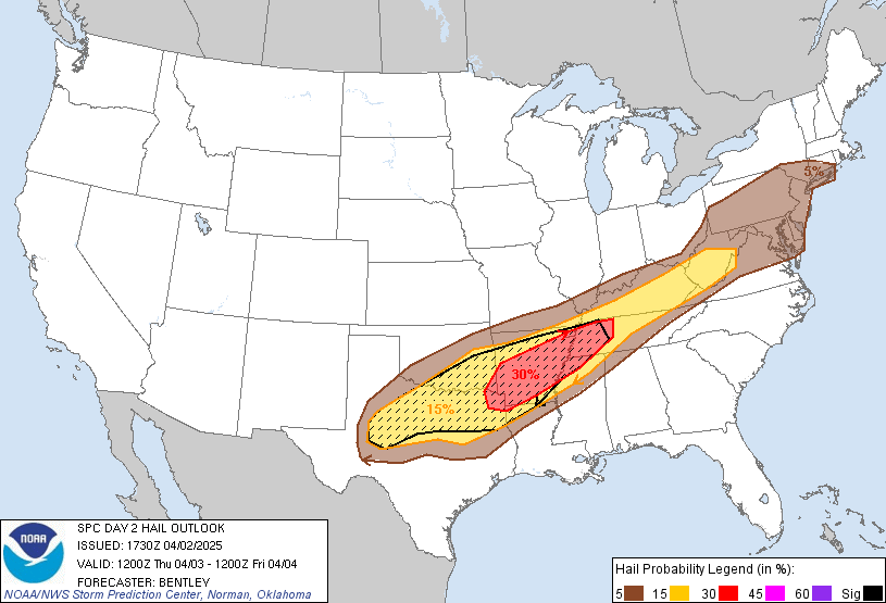
Posted on 4/8/21 at 1:12 pm to NorthEndZone
Further East than the morning SPC discussion hinted at, too.
Posted on 4/8/21 at 1:12 pm to The Boat
quote:
PJ stop acting like anyone cares about South Louisiana. This is a North Louisiana problem.
If I lived in Walker I would upvote that post.

 Page 12 of 28

Popular
Back to top