- My Forums
- Tiger Rant
- LSU Recruiting
- SEC Rant
- Saints Talk
- Pelicans Talk
- More Sports Board
- Fantasy Sports
- Golf Board
- Soccer Board
- O-T Lounge
- Tech Board
- Home/Garden Board
- Outdoor Board
- Health/Fitness Board
- Movie/TV Board
- Book Board
- Music Board
- Political Talk
- Money Talk
- Fark Board
- Gaming Board
- Travel Board
- Food/Drink Board
- Ticket Exchange
- TD Help Board
Customize My Forums- View All Forums
- Show Left Links
- Topic Sort Options
- Trending Topics
- Recent Topics
- Active Topics
Started By
Message
re: Severe Weather 4/4-4/5 - severe storms ongoing from Arkansas to Michigan.
Posted on 4/4/23 at 11:52 am to tarzana

Posted on 4/4/23 at 11:52 am to tarzana
quote:
The incredible thing was that these events occurred long before climate change really kicked in.
Because severe weather has always existed, and occasionally these historic events are going to happen.
 2
2


Posted on 4/4/23 at 11:55 am to Roll Tide Ravens
using logic?

Posted on 4/4/23 at 12:10 pm to Pedro
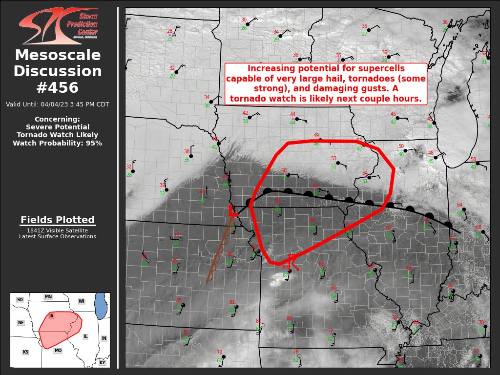
SPC just extended the moderate and enhanced sections further West into the more populated areas of NWA
Posted on 4/4/23 at 12:25 pm to Roll Tide Ravens
quote:
Because severe weather has always existed, and occasionally these historic events are going to happen.
That's true, but...two EF-4 tornadoes in Arabi, in less than one year's time? Come on, man!
Posted on 4/4/23 at 12:28 pm to tarzana
Posted on 4/4/23 at 12:28 pm to tarzana
quote:
That's true, but...two EF-4 tornadoes in Arabi, in less than one year's time? Come on, man!
There were some places around Tanner, AL that were hit by two F-5 tornadoes on the same night during the 1974 Super Outbreak.
This post was edited on 4/4/23 at 12:29 pm
Posted on 4/4/23 at 12:33 pm to Pedro
Wow...that is awe-inspiring!
Posted on 4/4/23 at 12:37 pm to BallHawg10
quote:
SPC just extended the moderate and enhanced sections further West into the more populated areas of NWA
This is a tricky forecast. There hasn't been much in the way of consistency across models. That includes everything from the speed and position of the trough to where the dry line sets up and how far east it gets to temps across the warm sector.
The biggest issue at play is dry air aloft and a cap that will be in place for the southern mode. That is also a contributor as to why storms will fire late and why people shouldn't scream "bust" early with this one. The dry air will have to be overcome before storms can really take off. That could happen well after dark when the LLJ kicks in. Shear won't be an issue, CAPE won't be an issue, but that dry air and cap that is in the place can be a failure mode.
We haven't gotten any observed soundings across the area since this morning. Hopefully, we get some from the Noon hour to see how things are shaping up.
Posted on 4/4/23 at 12:38 pm to tarzana
quote:
two EF-4 tornadoes in Arabi
Wut?
Posted on 4/4/23 at 12:44 pm to notiger1997
quote:
Wut?
He's hysterical and making shite up. Probably best to just ignore him.
Posted on 4/4/23 at 12:46 pm to Roll Tide Ravens
quote:
There were some places around Tanner, AL that were hit by two F-5 tornadoes on the same night during the 1974 Super Outbreak.
Sure did.
Then, the Hackleburg/Phil Campbell tornado on 4/27/2011 was still an EF5 when it tracked through roughly the same area.
If you map all the tornadoes around the Tanner area over the years, you can't see the town on the map.
This post was edited on 4/4/23 at 12:47 pm
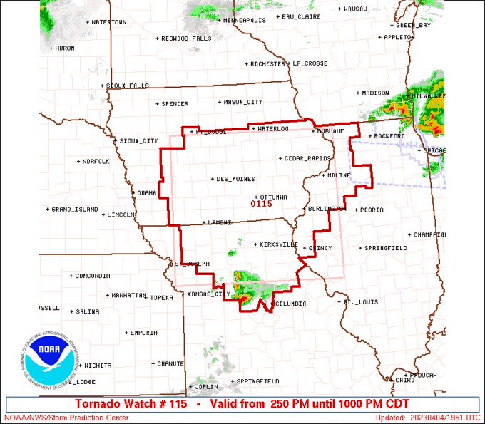
Posted on 4/4/23 at 12:56 pm to LegendInMyMind
Quad Cities, IA got hammered with 90 mph winds and up to 3 inch hail in some places.
quote:
PRELIMINARY LOCAL STORM REPORT
NATIONAL WEATHER SERVICE QUAD CITIES IA IL
1014 AM CDT TUE APR 4 2023
..TIME... ...EVENT... ...CITY LOCATION... ...LAT.LON...
..DATE... ....MAG.... ..COUNTY LOCATION..ST.. ...SOURCE....
..REMARKS..
0946 AM TSTM WND GST 1 W MOLINE QUAD-CITY AI 41.45N 90.52W
04/04/2023 M90 MPH ROCK ISLAND IL ASOS
ASOS STATION KMLI QUAD CITY INTL ARPT.
quote:
PRELIMINARY LOCAL STORM REPORT
NATIONAL WEATHER SERVICE QUAD CITIES IA IL
955 AM CDT TUE APR 4 2023
..TIME... ...EVENT... ...CITY LOCATION... ...LAT.LON...
..DATE... ....MAG.... ..COUNTY LOCATION..ST.. ...SOURCE....
..REMARKS..
0951 AM HAIL 2 E DAVENPORT 41.56N 90.57W
04/04/2023 E3.00 INCH SCOTT IA NWS EMPLOYEE
NEAR NORTHPARK MALL.

Posted on 4/4/23 at 1:16 pm to Roll Tide Ravens
what time can I expect this thing to move through the Memphis area?
Posted on 4/4/23 at 1:23 pm to Rebel
looks like the timing for the bad stuff is sometime after 6 AM
Posted on 4/4/23 at 1:24 pm to Pedro
Not until tomorrow?
Thanks for the information.
Thanks for the information.
Posted on 4/4/23 at 1:28 pm to Rebel
quote:
Not until tomorrow?
Thanks for the information.
Yeah, you're caught in that gap between outlooks. Timing-wise it could go on either day's outlook.
Posted on 4/4/23 at 1:40 pm to LegendInMyMind
Is that storm going to Chicago getting appendagy? Yeah just created a word. LOL
This post was edited on 4/4/23 at 1:41 pm
Posted on 4/4/23 at 1:55 pm to lsuman25
Posted on 4/4/23 at 2:03 pm to LegendInMyMind
quote:
Then, the Hackleburg/Phil Campbell tornado on 4/27/2011 was still an EF5 when it tracked through roughly the same area. If you map all the tornadoes around the Tanner area over the years, you can't see the town on the map.
That area through Athens/Decatur through to the AL/TN line along with central MS between I20 to I59 through to Tuscaloosa would be my Dixie Alley epicenters.
Posted on 4/4/23 at 2:56 pm to tide06

 Page 3 of 11

Popular
Back to top