




 1
1








- My Forums
- Tiger Rant
- LSU Recruiting
- SEC Rant
- Saints Talk
- Pelicans Talk
- More Sports Board
- Fantasy Sports
- Golf Board
- Soccer Board
- O-T Lounge
- Tech Board
- Home/Garden Board
- Outdoor Board
- Health/Fitness Board
- Movie/TV Board
- Book Board
- Music Board
- Political Talk
- Money Talk
- Fark Board
- Gaming Board
- Travel Board
- Food/Drink Board
- Ticket Exchange
- TD Help Board
Customize My Forums- View All Forums
- Show Left Links
- Topic Sort Options
- Trending Topics
- Recent Topics
- Active Topics
Started By
Message
Posted on 4/18/19 at 7:10 pm to rt3
Wind now is the biggest thing all day.
Posted on 4/18/19 at 7:12 pm to rt3
shite
Posted on 4/18/19 at 7:29 pm to LooseCannon22282
Left prairieville at 430 and headed east.
Not wise
Not wise
Posted on 4/18/19 at 7:31 pm to Ba Ba Boooey
Philadelphia, Miss.
Posted on 4/18/19 at 7:52 pm to notiger1997
quote:
Were you wanting the blue ribbon or the chocolate chip cookie for your hard hitting work at outing the weather folks and showing everyone how right you were?
I wasn’t right about anything.
You guys are far more accurate with winter weather. Even the pros were off today. It ain’t an exact science. Keep doing what you do and I’ll be here to bust your balls. I’d rather y’all be wrong than right. I don’t need any more shite to clean up.

Posted on 4/18/19 at 7:57 pm to tigerinthebueche
Got lucky we made it out of huntsville earlier, that lightning pic a page back looked rough. Hope everyone is staying safe out there tonight. Even luckier that our inbound flight to buffalo was coming from birmingham and managed to take off right as the storm front was hitting Flightaware BHM-ATL
Posted on 4/18/19 at 8:09 pm to rt3
What's happening here are 2 squall lines going to develop? I thought the first one would take all the energy out of the atmosphere
Posted on 4/18/19 at 8:14 pm to angus1838
It should eventually form up into one line. There's still a healthy low level flow out of the gulf the backline is able to feed on now the primary line has a little separation from it.
Should merge up overnight.
Should merge up overnight.
Posted on 4/18/19 at 8:14 pm to angus1838
Yeah the main line just rolled through south Alabama. Lot of lighting and some rain. looking at the radar doesn’t show much of anything else. Is something gonna blow up tonight?
Posted on 4/18/19 at 8:15 pm to AHM21
We had some some strong straight line winds in Tuacaloosa
Posted on 4/18/19 at 8:16 pm to biggsc
The winds up in northern Alabama are kind of amazing. There's about zero instability left. There's no lightning. Yet we've got a hook of severe warnings just riding the high winds this system is pushing out.
Posted on 4/18/19 at 8:18 pm to Duke
Is it going to be worse or better when they merge? By the way thank y'all for these weather threads I look to y'all first and really love the way y'all explain things.
Posted on 4/18/19 at 8:21 pm to angus1838
Shouldn't make a huge difference. It'll basically end up with the dominant line just being the one line. Intensity on the south end should very slowly wane overnight. At least that's the last I saw model wise.
It'll still be a strong squall in Georgia by morning and serve for a SE Ga and NE Florida severe threat tomorrow.
It'll still be a strong squall in Georgia by morning and serve for a SE Ga and NE Florida severe threat tomorrow.
Posted on 4/18/19 at 8:23 pm to Duke
Probably from Gravity waves
Posted on 4/18/19 at 8:28 pm to Duke
Thanks man I am in the very southeast corner of Alabama and it looks like they are going to merge over the top of us. Really curious if there is an uptick in severity when they merge as opposed to when they are separated?
Posted on 4/18/19 at 9:55 pm to tigerinthebueche
quote:
You guys are far more accurate with winter weather. Even the pros were off today.
Not really on either account.
The tornado risk was projected to be in the southern half of MS and AL today last night from the SPC. It was agreeable with what all the convective allowing models were showing. As I noted on page 23 of the thread when it came out at 1 am:
quote:
Wind within the storms tomorrow is the biggest risk for us in south Louisiana.
Doing a late look at the short range modeling, it's been quite a spread. The 00z NAM has storms firing pretty early, like 10 am, and not having much instability in place. Overall, it's not showing any extreme scenarios. The HRRR is more bullish and gets the storms going a little later. Soundings produced are suggestive of stronger tornado potential, but the linear/cluster presentation isn't likely to yield that.
The HRW sets set the best tornado risk north of Louisiana too, with a cluster/line coming through after lunch.
Overall, not too bad for Louisiana as it stands but uncertainty remains.
This still overdid the south Louisiana impacts, but the set up was clearly favoring north of here by last night.
SPC in their midday update came with this:
quote:
Nevertheless, potential exists for scattered to widespread damaging winds along with short-track tornadoes (a few of which may be significant). The most likely region for these hazards to occur is across MS this afternoon and AL this evening.
We talked a lot this morning of how the worst risk was for Mississippi and eventually Alabama. That it was more a high wind risk for Louisiana. That didn't materialize for the most part.
Now just to toot my own horn:
At 3:08 pm
quote:
There's an open slot in convection heading toward 55 up that way. Lower levels flowing in from the SE, meeting the W moving energy. That intersection could easily fire severe storms on the lead edge of the line.
Issued a minute later:

At 3:56 pm
quote:
Bogalusa to Hattiesburg, anywhere in front of the main line should be on the lookout for tornado warnings over the next couple of hours.
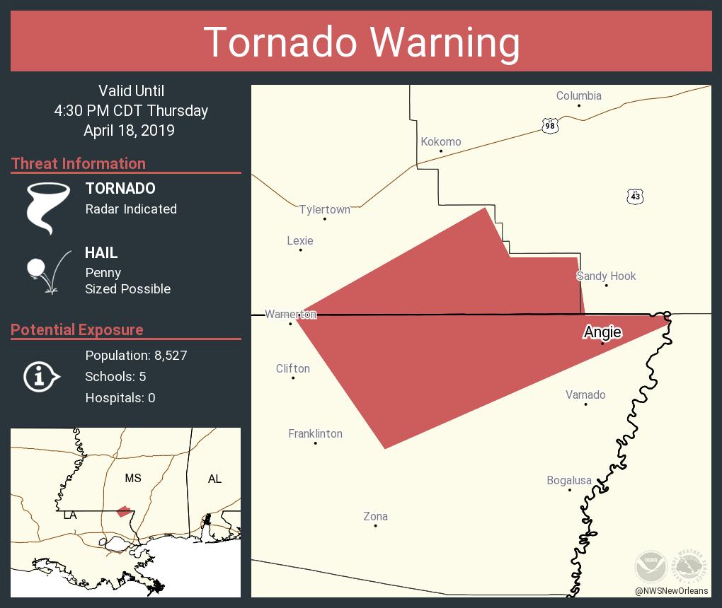
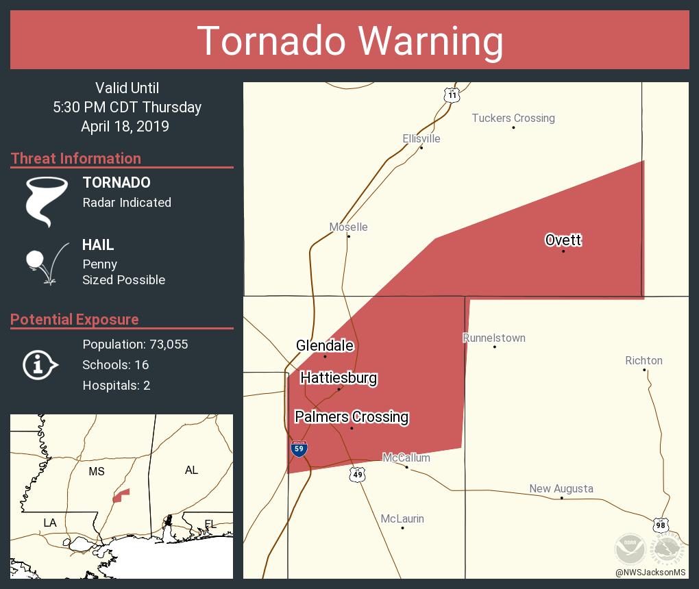
Forecasts are hard. The SPC is the best in the world at them and set the stage well for the risk, what factors could limit the risk, and set up last night the highest risk zone that was actually where most of the wind damage and tornadoes ended up being.
There was discussion yesterday morning from every NWS office in the potential worst areas about the risk and they mentioned the limiting potential of a cluster/line of storms.
We discussed it in this thread yesterday too.
All of this said, I'm still glad everyone is bitching about the "bust" down here. Means we didn't get much damage and the risk didn't materialize. Will take that outcome every fricking time.
Posted on 4/18/19 at 10:00 pm to Duke
quote:
just to toot my own horn:
.
well done Duke. Posted on 4/18/19 at 10:10 pm to tigerinthebueche

quote:
SUMMARY...Storms are expected to develop eastward into southeast AL, the central FL Panhandle and southwest GA overnight. Primary threats will be damaging wind and isolated tornadoes. Trends are being monitored for a possible WW.
quote:
DISCUSSION...Broken band of storms from south central AL into the extreme western FL Panhandle continues eastward at around 30 kt. Tendency has been for the storms inland from the coast to out pace the greater low-level jet and destabilization. With exception of the northern end of the line, overall storms appear poorly organized. However, the low-level jet will gradually develop eastward tonight, and resulting moist advection should contribute to northward destabilization with time. Recent observations show dewpoints increasing to the upper 60s over coastal Fl and moisture should continue to increase farther inland with time. This suggests that storms may become better organized later this evening and especially into the overnight with low-level hodographs and effective bulk shear becoming supportive of organized structures capable of damaging wind and isolated tornadoes.
Posted on 4/18/19 at 10:30 pm to Duke
Yikes. Just left a family reunion in Santa Rosa. Some relatives are still there. Namely, my mil.

 Page 67 of 69


Popular

Back to top
 Follow TigerDroppings for LSU Football News