- My Forums
- Tiger Rant
- LSU Recruiting
- SEC Rant
- Saints Talk
- Pelicans Talk
- More Sports Board
- Fantasy Sports
- Golf Board
- Soccer Board
- O-T Lounge
- Tech Board
- Home/Garden Board
- Outdoor Board
- Health/Fitness Board
- Movie/TV Board
- Book Board
- Music Board
- Political Talk
- Money Talk
- Fark Board
- Gaming Board
- Travel Board
- Food/Drink Board
- Ticket Exchange
- TD Help Board
Customize My Forums- View All Forums
- Show Left Links
- Topic Sort Options
- Trending Topics
- Recent Topics
- Active Topics
Started By
Message
re: Severe Weather - Today - LA, MS, AL, NW FL
Posted on 4/18/19 at 5:54 pm to Tigerbait357
Posted on 4/18/19 at 5:54 pm to Tigerbait357
Any idea how much rain fell in BTR? The last few hours have been a constant downpour.
 0
0

Posted on 4/18/19 at 5:55 pm to rt3
quote:
Jacob Dickey @jacobdickeywx
Shed blown over west of Macon. Still very gusty winds here.

Posted on 4/18/19 at 5:56 pm to theOG
quote:
Am I in for a ride tonight in Point Clear?
If you play your cards right.

Posted on 4/18/19 at 6:00 pm to slackster
Slack 
Posted on 4/18/19 at 6:03 pm to 50_Tiger
quote:
50_Tiger
You jumped ship at the best time today.

Posted on 4/18/19 at 6:05 pm to Bobby OG Johnson
quote:

That off 42 by WalMart?
Posted on 4/18/19 at 6:06 pm to im4LSU
quote:
NWS Birmingham @NWSBirmingham
Tuscaloosa: Prepare for possible damaging winds! Line of storms will move into the downtown area within the next 15 min. Seek shelter now! #alwx
Posted on 4/18/19 at 6:07 pm to im4LSU
quote:
NWS Birmingham @NWSBirmingham
Damaging winds up to 70 mph are possible with the line. Please seek shelter NOW! #alwx
Posted on 4/18/19 at 6:08 pm to im4LSU
Newsreportee asking someone stuck in knee deep water if they called police.... good god water was so shallow dude probably ran out if gas
Posted on 4/18/19 at 6:08 pm to rt3
quote:
.Line of storms along the MS/AL border continues eastward. Organized embedded structures continue to be observed including comma/bowing structure on the northern end over west central AL. This activity is moving east northeast at 40-45 kt, and will approach the Birmingham area around 00Z. This portion of the line has moved north of the greater low-level moisture, instability and low-level jet which suggests it may eventually weaken. In the meantime, strong mesoscale organization and forcing along and just south of the comma head region should help to sustain the storms another 2-3 hours. The southwestern extension of the line is moving slower at 30-35 kt. However, closer proximity to the eastward-migrating low-level jet with very moist inflow suggests these storms will remain capable of occasional organization including embedded supercells next few hours.
Posted on 4/18/19 at 6:09 pm to im4LSU
I have no clue. WSFA retweeted it and it just said that a viewer captured it while recording in Petal.
Posted on 4/18/19 at 6:15 pm to Bobby OG Johnson
quote:
NWS Birmingham @NWSBirmingham
Closely watching small area of rotation in far SW Lamar County. No plans for a warning at this time, but remain alert. #alwx
Posted on 4/18/19 at 6:18 pm to rt3
quote:
Hank @MSmudHburg
@NWSJacksonMS @NickLilja Rain accum start to 6:00pm. 1 mile SW of downtown Burg.

Posted on 4/18/19 at 6:25 pm to theOG
quote:
Am I in for a ride tonight in Point Clear?
Ought to be an awesome view of the lightshow coming over the bay. Lot of lightning rolling in.

Posted on 4/18/19 at 6:32 pm to Duke
Rain is getting out ahead of the main line of storms somewhat stabilizing the atmosphere.
Still it was a quick, but strong storm to come through just a moment ago.
Still it was a quick, but strong storm to come through just a moment ago.
Posted on 4/18/19 at 6:38 pm to East Coast Band
quote:
Rain is getting out ahead of the main line of storms somewhat stabilizing the atmosphere.
Yep.
The best stuff is going to be progressively more south. That big swirly that has been firing so many tornadoes is starting to outrun the moisture too.
Posted on 4/18/19 at 6:39 pm to East Coast Band
quote:
NWS Birmingham @NWSBirmingham
2 areas of rotation in far E Lamar County - 1 near Crossville & 1 near Kennedy. These are moving E into Fayette County. There is a Severe Thunderstorm Warning WITH a TOR possible tag. We are watching closely in case a Tornado Warning is necessary. #alwx
Posted on 4/18/19 at 6:44 pm to rt3
quote:
NWS Birmingham @NWSBirmingham
High winds are occurring BEHIND the line of storms as well. Gusts to 53 mph reported at the Tuscaloosa Airport recently. #alwx
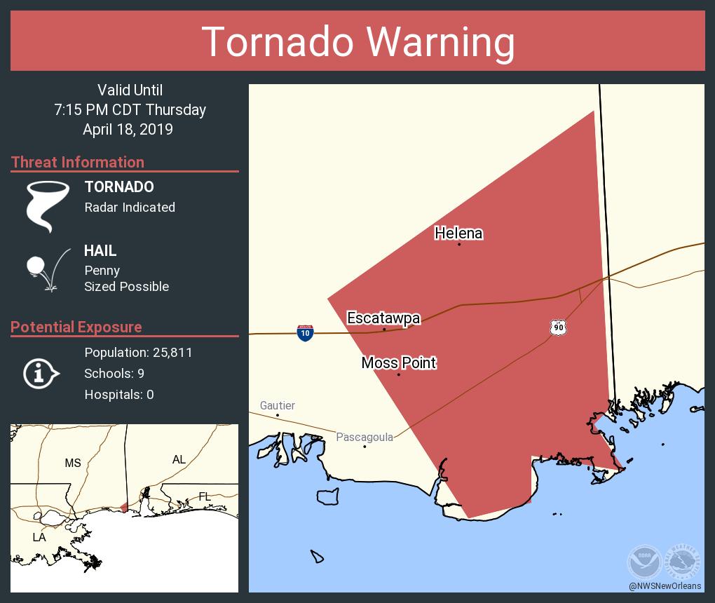
Posted on 4/18/19 at 6:55 pm to rt3
Posted on 4/18/19 at 6:56 pm to AHM21
Be safe brother.

 Page 66 of 69

Popular
Back to top