- My Forums
- Tiger Rant
- LSU Recruiting
- SEC Rant
- Saints Talk
- Pelicans Talk
- More Sports Board
- Coaching Changes
- Fantasy Sports
- Golf Board
- Soccer Board
- O-T Lounge
- Tech Board
- Home/Garden Board
- Outdoor Board
- Health/Fitness Board
- Movie/TV Board
- Book Board
- Music Board
- Political Talk
- Money Talk
- Fark Board
- Gaming Board
- Travel Board
- Food/Drink Board
- Ticket Exchange
- TD Help Board
Customize My Forums- View All Forums
- Show Left Links
- Topic Sort Options
- Trending Topics
- Recent Topics
- Active Topics
Started By
Message

 1
1

Posted on 9/13/20 at 10:24 am to stout
quote:K, I've trying to find how many Entergy customers in SW Louisiana are still without power but can't find an updated number. Do you know what Entergy is saying about their number without power?
Trying to wait out having power as long as I can to see if today they get power at my house in LC.
Posted on 9/13/20 at 10:24 am to MrLSU

Posted on 9/13/20 at 10:24 am to Lord_Ford
quote:
I hate to break it to y’all, but we can handle a CAT 1 in Baton Rouge just fine.
I sure hope so. I was planning to leave NOLA tomorrow morning and ride it out in the red stick.
Posted on 9/13/20 at 10:25 am to MrLSU
Posted on 9/13/20 at 10:25 am to rds dc
when is the shear supposed to decrease?

Posted on 9/13/20 at 10:27 am to Spasweezy
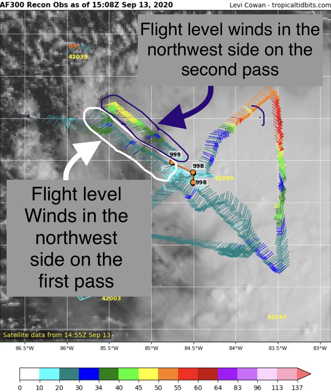
12Z Icon and NAMs shifted a good bit east from previous runs. Interesting. Doesn't mean much but will have to see if other 12z models start to do the same. Maybe.
Posted on 9/13/20 at 10:29 am to MrLSU
Posted on 9/13/20 at 10:29 am to MrLSU
Slidell here around Gause Blvd . Almost at I’12 what can we expect as far as winds?
Posted on 9/13/20 at 10:29 am to EXPLAYER
Posted on 9/13/20 at 10:30 am to tgrgrd00
quote:
12Z Icon and NAMs
Depending on which resolution NAM (3k) you use, it actually went west of its prior run.
ICON certainly took a NE turn once making landfall in Plaquemines
Posted on 9/13/20 at 10:31 am to tgrbaitn08
quote:
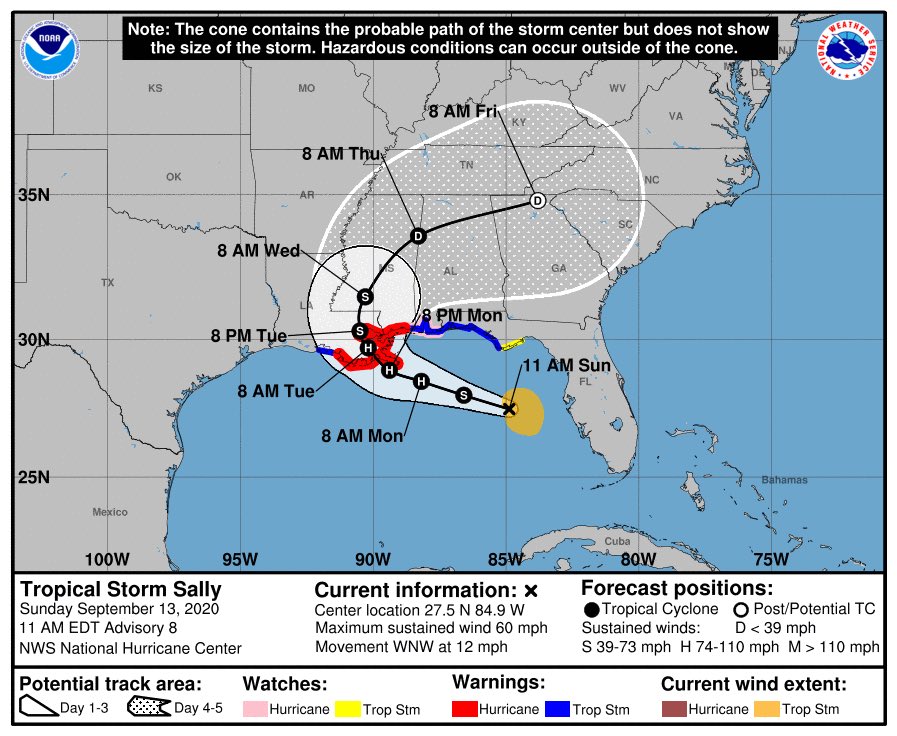
Downgraded to a CAT 1
You need to read the discussion. Says it could be a Cat 2 between 12 hour data points. Which means it would not be a Cat 2 for long, but it could happen.

Posted on 9/13/20 at 10:33 am to LSURussian
quote:
Do you know what Entergy is saying about their number without power?
59K as of yesterday evening
Posted on 9/13/20 at 10:35 am to stout
quote:Damn!
59K as of yesterday evening
Thanks.
Posted on 9/13/20 at 10:36 am to MrLSU
So tropical storm winds . Will tornados be out in front of this storm? I am visiting family and we are in Slidell not sure what to orry about.
Posted on 9/13/20 at 10:36 am to EXPLAYER
60-64 mph winds sustained it looks like
This post was edited on 9/13/20 at 10:38 am
Posted on 9/13/20 at 10:37 am to LSURussian
quote:
Damn!
Thanks.
FYI that's not counting the other service providers that other areas have like Cleco, BECI, etc
This post was edited on 9/13/20 at 10:38 am
Posted on 9/13/20 at 10:37 am to SoloTiger
quote:Yes, by about 15 miles or so. I was looking at the west eyeball, now I'm looking at the east eyewall.
Thats a lot of info. I just want to know if forecast track shifted any further west from 7 am to 10 am.
Posted on 9/13/20 at 10:38 am to stout
quote:
59K as of yesterday evening
If Sally causes significant damage it’s gonna be bad. Crews and materials are tapped out. I can’t imagine what the plan will be to restore another area of the service territory

Posted on 9/13/20 at 10:39 am to rds dc
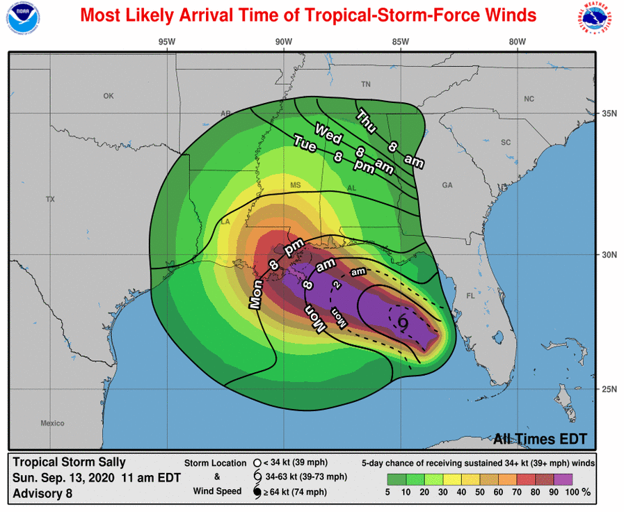
Okay stupid question from a weather idiot.
Does anyone know of a resource online that updates with the tracks they may give a general idea of projected wind speeds in a given area like Covington/Mandeville? Wind will be my biggest issue. I see sometimes the news channels do it but was wondering if it was online somewhere.
Does anyone know of a resource online that updates with the tracks they may give a general idea of projected wind speeds in a given area like Covington/Mandeville? Wind will be my biggest issue. I see sometimes the news channels do it but was wondering if it was online somewhere.

 Page 61 of 298

Popular
Back to top