- My Forums
- Tiger Rant
- LSU Recruiting
- SEC Rant
- Saints Talk
- Pelicans Talk
- More Sports Board
- Coaching Changes
- Fantasy Sports
- Golf Board
- Soccer Board
- O-T Lounge
- Tech Board
- Home/Garden Board
- Outdoor Board
- Health/Fitness Board
- Movie/TV Board
- Book Board
- Music Board
- Political Talk
- Money Talk
- Fark Board
- Gaming Board
- Travel Board
- Food/Drink Board
- Ticket Exchange
- TD Help Board
Customize My Forums- View All Forums
- Show Left Links
- Topic Sort Options
- Trending Topics
- Recent Topics
- Active Topics
Started By
Message
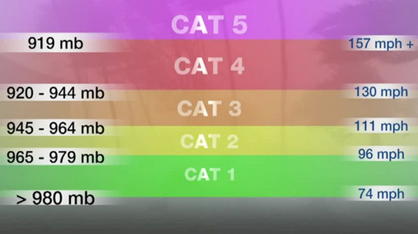
 4
4


Posted on 9/12/20 at 12:21 pm to DiamondDog
quote:
DiamondDog
You sound like a piece of shite
What a shitty fricking thing to say.

Posted on 9/12/20 at 12:22 pm to Duke

Posted on 9/12/20 at 12:23 pm to fishfighter
quote:
I have to go to Houston, leaving here Wednesday. I can't put this trip off. Last storm hit, I was suppose to be in Houston, but had to cancel that trip. It's very hard to get a doctors appointment were I have to go. Very little treatment for ALS here in Louisiana.
I do have a hotel room booked for two nights.
Best of luck to you. My stepdad had ALS and had the same problem-- he had to go to Houston to get a diagnosis. Docs in Lafayette kept telling him it was "nothing".
Posted on 9/12/20 at 12:24 pm to Duke
And sure enough that’s a strong Cat 2 it’s projecting.
The absolute state of this year
The absolute state of this year
Posted on 9/12/20 at 12:29 pm to LegendInMyMind
quote:
It really is uncanny how well they've done this year in regards to intensity. Development and tracking has left a lot to be desired, but intensity has been spot on.
Uhhhhh

Posted on 9/12/20 at 12:31 pm to Duke
Well let's hope it's wrong this time...

Posted on 9/12/20 at 12:32 pm to Ed Osteen
quote:
Why do you continue to make predictions in these threads? It’s well documented and every person here knows you have no clue what you are talking about.
It’s the stupidest shite known to man.
Posted on 9/12/20 at 12:33 pm to Duke
quote:
Speaking of the HWRF...
The 12z is ugly.

Sheeeeeit. This would be bad
Posted on 9/12/20 at 12:34 pm to dukke v
quote:
They are saying a Tuesday landfall... not enough time to intensify. It may reach hurricane strength, but will not get to a cat 2. Even though the weather channel is hoping it will.....
Cat 4 incoming
Posted on 9/12/20 at 12:35 pm to Duke
We go from predicted highs in the 60s two weeks ago to another hurricane.
Seriously 2020. frick off
Seriously 2020. frick off
Posted on 9/12/20 at 12:35 pm to Duke
quote:
The HWRF has gotten very good at intensity.
This is not good news if you look at their latest run
Posted on 9/12/20 at 12:37 pm to deltaland
Posted on 9/12/20 at 12:39 pm to PhillyTiger90
quote:
And sure enough that’s a strong Cat 2 it’s projecting.
HWRF model is showing strong Cat 3.
953 is a solid 3.
Posted on 9/12/20 at 12:42 pm to deltaland
Here’s what jay grimes just posted:
quote:
TD #19 is moving into the southeast Gulf and becomes Sally later today. I won’t be surprised to see a modest shift in the center location but that is not especially important.
The environment over the eastern/southeastern Gulf is primed to support a storm. Surface water temperatures (SSTs) are in the mid to upper 80°s and the SSTs over the eastern Gulf are more than warm enough. Wind shear for the next couple of days looks to be rather light and there isn’t any significant “dry” air in the region. All these factors point to the intensification that the NHC expects, with TD #19 forecasted to become a hurricane by Monday.
I would not be surprised to see this system reach Category 1 sooner. And frankly, a more rapid intensification could lead to a more northerly track from Sunday into Tuesday, potentially taking SE Louisiana out of the landfall equation. But let's not count on that.
There is still quite a bit of uncertainty about the regional steering components as we go from Sunday into Monday.
Also note that the system's forward speed is expected to slow considerably from Sunday evening into Tuesday. That slowing is troublesome since slower storms are typically harder to forecast because of the lack of consistent, well-defined steering features.
For Louisiana and the central Gulf Coast, that slower approach can also mean bigger issues with surge.
For the Louisiana coast and tidal lakes, east-to-northeast winds will start to pile up the water well ahead of the storm: water levels are already starting to respond at several sites along the SE coast.
At this point, the thinking is that most of the state will avoid a hard hit. But don’t let your guard down.
Posted on 9/12/20 at 12:44 pm to Glock17
thanks for posting that
Posted on 9/12/20 at 12:49 pm to rocket31
Posted on 9/12/20 at 12:59 pm to MrLSU
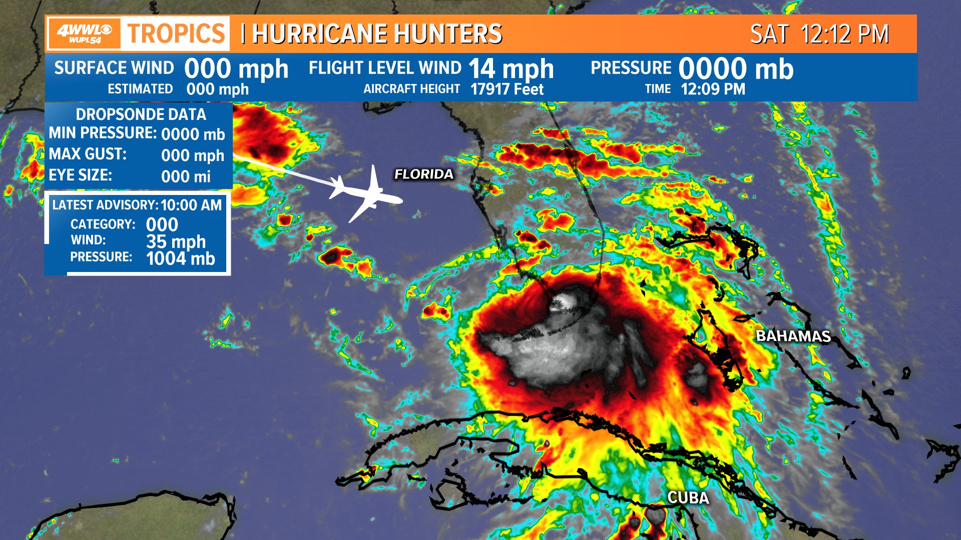
...DEPRESSION BECOMES A TROPICAL STORM...
2:00 PM EDT Sat Sep 12
Location: 25.6°N 81.6°W
Moving: W at 7 mph
Min pressure: 1004 mb
Max sustained: 40 mph
2:00 PM EDT Sat Sep 12
Location: 25.6°N 81.6°W
Moving: W at 7 mph
Min pressure: 1004 mb
Max sustained: 40 mph
Posted on 9/12/20 at 1:01 pm to Glock17
Model deep dive?
Probably time.
First question is early strengthening. You've heard stronger will tend north and that is true in the short run, but won't matter as much by Monday. Here's why...

See the lines dipping down over the Great Lakes and Ohio Valley? This trough (which would have been our cold front in a better world) will want to pull a stronger storm a little north. A stronger storm is taller and will feel the pull north more. It's weak and pulling away but there's a solid 24 hour window for a stronger storm to get a little shove north.
This would tend to have it end up farther east by landfall.
The problem is this window closes up by Monday.

Ridge builds in over the south by midday on Monday and this will push anything west. The storm will slow down also.

Then by Tuesday the ridge has re-oriented to the east of the storm and pushes it north and inland.
The question at play here is just how fast this thing gets to the west by early Monday. The HMON vs the HWRF show what those differences might mean.
The HWRF is faster.
Monday Morning:

vs the HMON
Midnight Tuesday Morning:

The HWRF ends up in Pontchartrain and the HMON goes Mobile Bay. Same response to the steering, different location due to how fast it moves early on.
Now for strength. Concern is definitely rising with that stronger HWRF run and the HMON showing a 2. Additionally the globals are trending stronger to support this idea. The why of it is simple, shear remains pretty low and the water is warm. Plus an upper high will be set up by Monday which would enhance outflow. Unfortunately this suggests potential strengthening into a landfall.


That's the state of play right now, concern for a stronger storm into the Cat 2 range is certainly here. Track with uncertainty remaining. One certainty is someone east of the track is going to get a tremendous amount of rain. Right now I'd put the likely landfall spots between Grand Isle and Fort Morgan. You know, roughly what the much better mets at the NHC are projecting.
Probably time.
First question is early strengthening. You've heard stronger will tend north and that is true in the short run, but won't matter as much by Monday. Here's why...
See the lines dipping down over the Great Lakes and Ohio Valley? This trough (which would have been our cold front in a better world) will want to pull a stronger storm a little north. A stronger storm is taller and will feel the pull north more. It's weak and pulling away but there's a solid 24 hour window for a stronger storm to get a little shove north.
This would tend to have it end up farther east by landfall.
The problem is this window closes up by Monday.
Ridge builds in over the south by midday on Monday and this will push anything west. The storm will slow down also.
Then by Tuesday the ridge has re-oriented to the east of the storm and pushes it north and inland.
The question at play here is just how fast this thing gets to the west by early Monday. The HMON vs the HWRF show what those differences might mean.
The HWRF is faster.
Monday Morning:
vs the HMON
Midnight Tuesday Morning:
The HWRF ends up in Pontchartrain and the HMON goes Mobile Bay. Same response to the steering, different location due to how fast it moves early on.
Now for strength. Concern is definitely rising with that stronger HWRF run and the HMON showing a 2. Additionally the globals are trending stronger to support this idea. The why of it is simple, shear remains pretty low and the water is warm. Plus an upper high will be set up by Monday which would enhance outflow. Unfortunately this suggests potential strengthening into a landfall.
That's the state of play right now, concern for a stronger storm into the Cat 2 range is certainly here. Track with uncertainty remaining. One certainty is someone east of the track is going to get a tremendous amount of rain. Right now I'd put the likely landfall spots between Grand Isle and Fort Morgan. You know, roughly what the much better mets at the NHC are projecting.
This post was edited on 9/12/20 at 1:03 pm
Posted on 9/12/20 at 1:01 pm to rocket31
we have Sally
quote:
...DEPRESSION BECOMES A TROPICAL STORM...
2:00 PM EDT Sat Sep 12
Location: 25.6°N 81.6°W
Moving: W at 7 mph
Min pressure: 1004 mb
Max sustained: 40 mph

 Page 19 of 298

Popular
Back to top