- My Forums
- Tiger Rant
- LSU Recruiting
- SEC Rant
- Saints Talk
- Pelicans Talk
- More Sports Board
- Fantasy Sports
- Golf Board
- Soccer Board
- O-T Lounge
- Tech Board
- Home/Garden Board
- Outdoor Board
- Health/Fitness Board
- Movie/TV Board
- Book Board
- Music Board
- Political Talk
- Money Talk
- Fark Board
- Gaming Board
- Travel Board
- Food/Drink Board
- Ticket Exchange
- TD Help Board
Customize My Forums- View All Forums
- Show Left Links
- Topic Sort Options
- Trending Topics
- Recent Topics
- Active Topics
Started By
Message
re: Sally - Moving towards Georgia - Potential for Significant Flooding
Posted on 9/12/20 at 7:55 am to Prominentwon
Posted on 9/12/20 at 7:55 am to Prominentwon
quote:
That’s too many models coming into LC.
We didn’t get the surge for Laura. I guess God will be late bringing water to the party.
If this turns out to be a run event, we can’t take anymore here right now. Between the actual water and people’s mental health, it would be a shithow
As of now, no reliable model shows it getting that far west but that area is still inside the cone. Also, the current setup favors the heaviest rain to the east of the track.

 1
1

Posted on 9/12/20 at 7:55 am to rds dc
must be 2020 when florida now spinning up hurricanes left and right.
Posted on 9/12/20 at 8:00 am to rds dc
Damn keep those 15+ rain totals offshore.
Posted on 9/12/20 at 8:02 am to FLObserver
06z euro rides coast to Houma then turns N
12z TVCN not buying west shift so 10am NHC track won’t be shifting much west
Probably euro with west bias again
12z TVCN not buying west shift so 10am NHC track won’t be shifting much west
Probably euro with west bias again
Posted on 9/12/20 at 8:07 am to Midtiger farm
quote:
06z euro rides coast to Houma then turns N
12z TVCN not buying west shift so 10am NHC track won’t be shifting much west
Probably euro with west bias again
Yea, with Laura the Euro was constantly on the western edge of guidance and then the Euro EPS was even more so. However, the GEFS lines up pretty good with the EPS and we didn't see that with Laura. So who knows
This post was edited on 9/12/20 at 8:09 am

Posted on 9/12/20 at 8:16 am to rds dc
Levi
quote:
#TD19 is located over the Everglades this morning, bringing showers and gust winds to south Florida and the keys. Radar indicates the vortex remains slightly tilted SE with height, but less so than last night, indicating better organization. Some strengthening likely today.
Posted on 9/12/20 at 8:22 am to Bobby OG Johnson
HWRF getting Sally down to 963 and 100kt winds before BSL landfall.

ETA more like a Pass Christian or Gulfport landfall I suppose.
ETA more like a Pass Christian or Gulfport landfall I suppose.
This post was edited on 9/12/20 at 8:24 am
Posted on 9/12/20 at 8:28 am to rds dc
quote:
Also, the current setup favors the heaviest rain to the east of the track.
The HwRF and HMON aren’t showing much convection to the W and SW of Sally, even as they deepen the storm significantly.
Posted on 9/12/20 at 8:45 am to rds dc
06z Euro EPS pretty much in line with the 06z GEFS


Posted on 9/12/20 at 8:47 am to slackster
Do they have a good read on where the center is yet?
That will have a significant impact on the ultimate landfall
That will have a significant impact on the ultimate landfall

Posted on 9/12/20 at 8:52 am to SlidellCajun
If the steering currents remain the same, this thing is coming between Morgan City and Houma, due to the SW movement/relocation of the center. A lot can still happen between now and then though so who knows. Definitely not me 
Just my opinion.
Just my opinion.
This post was edited on 9/12/20 at 8:55 am
Posted on 9/12/20 at 8:56 am to SlidellCajun

Posted on 9/12/20 at 8:57 am to NorthEndZone

Newest EURO ensembles. The EURO was very west-biased for Laura so we shall see how it does with Sally.
Posted on 9/12/20 at 9:00 am to TDsngumbo
quote:
The EURO was very west-biased for Laura so we shall see how it does with Sally.
The difference with this system is that they are more aligned with the other guidance. They were a clear westward outlier with Laura.
Posted on 9/12/20 at 9:01 am to rds dc
That’s true. It would be insane if a cat 1 or 2 surprises sela in a few days.
Posted on 9/12/20 at 9:05 am to TDsngumbo
With the track projected to be very slow moving and then possibly curving All the way back to an ENE movement, the eastern side will get absolutely hammered with rainfall and surge regardless of the wind speeds. Could be 4 to 5 days of rain and onshore flow keeping water levels up.
Posted on 9/12/20 at 9:07 am to SlidellCajun
quote:
Do they have a good read on where the center is yet?
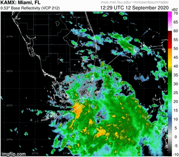
Current sat and radar seems to indicate that it is south of the last NHC fix. I posted earlier that even with radar & sat it can be hard to truly pin down the LLC at this point in development. Recon will be heading out in a bit and we'll get a good fix later today.
Posted on 9/12/20 at 9:27 am to rds dc
quote:
You can see on radar what appears to be the LLC rolling and contracting southwestward towards the apparent MLC associated with the very deep convection.
No, sir. I cannot distinguish on radar between the lower level convection and the mid level convection.
LLC and MLC acronyms: have I correctly stated what they stand for?
Posted on 9/12/20 at 9:28 am to Champagne
quote:
have I correctly stated what they stand for?
Yes
Posted on 9/12/20 at 9:44 am to rds dc
Does actually typing out the F word get me banned?????

 Page 13 of 298

Popular
Back to top