- My Forums
- Tiger Rant
- LSU Score Board
- LSU Recruiting
- SEC Rant
- SEC Score Board
- Saints Talk
- Pelicans Talk
- More Sports Board
- Coaching Changes
- Fantasy Sports
- Golf Board
- Soccer Board
- O-T Lounge
- Tech Board
- Home/Garden Board
- Outdoor Board
- Health/Fitness Board
- Movie/TV Board
- Book Board
- Music Board
- Political Talk
- Money Talk
- Fark Board
- Gaming Board
- Travel Board
- Food/Drink Board
- Ticket Exchange
- TD Help Board
Customize My Forums- View All Forums
- Show Left Links
- Topic Sort Options
- Trending Topics
- Recent Topics
- Active Topics
Started By
Message
re: Random geography trivia
Posted on 6/3/21 at 12:48 am to Tortious

Posted on 6/3/21 at 12:48 am to Tortious
quote:
Explain the Eastern most. I've heard all the rest and the civil eat one as well.
Aleutian Islands stretch almost to Russia. East vs West is not determined by the International Date Line, but by the 180th meridian.
 0
0

Posted on 6/3/21 at 1:07 am to Oilfieldbiology
quote:and China has just 1.
Russia spans 11 time zones.

Posted on 6/3/21 at 1:36 am to Spirit of Dunson
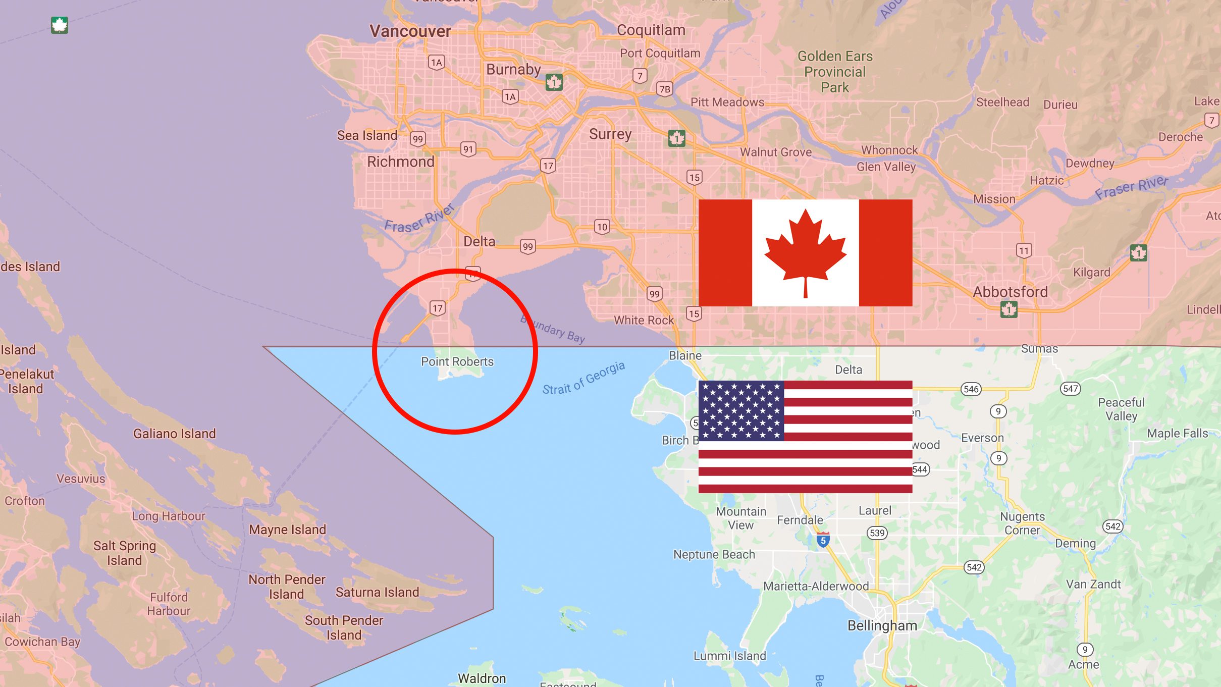
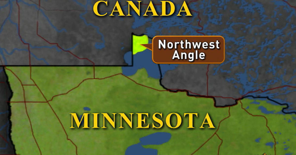
Due to the 49th parallel being the US/Canada border there are two parts of the US that are cut of from the rest of the mainland. Point Roberts, Washington and Northwest Angle, Minnesota. The only way back into the US from those two places in through Canada.
Posted on 6/3/21 at 1:41 am to The Boat
San Antonio is the second largest city in Texas. Most would probably guess Dallas or even Houston thinking Dallas is the biggest.
Posted on 6/3/21 at 1:45 am to The Boat
Like that little bit of Kentucky across the River from New Madrid. You have to drive through Tennessee to get to anywhere else in Kentucky.
Posted on 6/3/21 at 2:05 am to East Coast Band
Rhode Island is not an island and its not a road.
Posted on 6/3/21 at 2:14 am to Switzerland
I always just figured that Rhode guy was a fricking idiot.
Posted on 6/3/21 at 2:18 am to Duke
At over 500,000 people Fresno, California is the largest US city not connected to the interstate system.

Posted on 6/3/21 at 3:54 am to East Coast Band
90% of Canada's population lives south of the northern tip of Maine.
Posted on 6/3/21 at 5:58 am to Tortious
quote:
Explain the Eastern most. I've heard all the rest and the civil eat one as well.
Because a couple of the little pissant Aleutian Islands pass the 180th meridian you ignorant little twat
Posted on 6/3/21 at 6:46 am to hawkster
quote:
Missouri borders the most other states with 8.
Tennessee also borders 8 states.
Posted on 6/3/21 at 6:52 am to East Coast Band
Tristate, Tri-points or Triple points, aka trifiniums all mean the same thing. These are places where three States come together at a common point. Almost everyone is familiar with Four Comers in the southwestern U.S., where Utah, Colorado, Arizona and New Mexico meet at a spot in the Navajo Indian Reservation. However, not many people realize that there are sixty-one other spots where three States join. Of this total of sixty-two, thirty-eight either have markers or should have markers on land. The rest are in the middle of rivers, streams or lakes where no identifying marker can be placed.
This endeavor could be extended to include tri-points along the U.S.-Canadian and U.S.-Mexican borders. There are eleven locations where two U.S. States meet a Canadian province and seven more where one State hooks up with two provinces. Similarly, at three spots, two U.S. States join at a Mexican State, and at five other locations, it is two Mexicans adjoining one U.S. State. This gives a grand total of twenty-six locations of which only ten are on dry land.
LINK with pictures of markers

Posted on 6/3/21 at 7:29 am to East Coast Band
quote:
Baarle-Nassau is a municipality and town in the southern Netherlands. The town is the site of a complicated borderline between Belgium and Netherlands, with numerous small exclaves of the Belgian town Baarle-Hertog, some of which contain counter-exclaves of Nassau. Apart from the main parcel, known as Zondereigen and located north of the Belgian town of Merksplas, there are 22 Belgian exclaves in the Netherlands and three other parcels on the Dutch-Belgian border. There are also six Dutch exclaves located within the largest Belgian exclave, one within the second-largest, and an eighth within Zondereigen. The smallest Belgian parcel, H7, locally named De Loversche Akkers, measures 2,469 square metres (26,580 sq ft).

quote:
Walking through the Baarles is a unique experience. You constantly criss-cross between Belgium and the Netherlands. You will also notice that in the streets divided into Belgian and Dutch parts, there is no continuous numbering of houses. A street name and number can even occur twice: once in Baarle-Hertog and again in Baarle-Nassau. One house even has a front door where the border goes right through the middle of it.
What’s more, as each house is deemed to pay taxes in the country where its front door is located, it is an old tradition in Baarle to move the front door some metres if that creates a more favourable fiscal situation. This isn’t just crazy theory; it’s crazy practice too. More than one family has moved their front door from one country to another.
Posted on 6/3/21 at 7:51 am to crap4brain
Canada:
The distance from Alert, Nunavut to Pelee Island, Ontario is longer than the distance from Miami to Buenos Aires.
The distance from Alert, Nunavut to Pelee Island, Ontario is longer than the distance from Miami to Buenos Aires.

Posted on 6/3/21 at 7:53 am to VADawg
Seriously?
Posted on 6/3/21 at 7:55 am to Oilfieldbiology
Alert to Pelee Island = 2849 miles
Miami to Buenos Aires = 2738 miles
Alert to Pelee Island is basically going from the North Pole to Toledo, OH.
Miami to Buenos Aires = 2738 miles
Alert to Pelee Island is basically going from the North Pole to Toledo, OH.
This post was edited on 6/3/21 at 7:57 am
Posted on 6/3/21 at 7:56 am to lesgeaux
quote:
The easternmost point of St. Bernard Parish is 29 miles from Alabama
Yeah, I need an explanation on this one.

Posted on 6/3/21 at 8:00 am to East Coast Band
France’s longest shared border is with Brazil.
Posted on 6/3/21 at 8:03 am to cwil177
quote:
France’s longest shared border is with Brazil.
That's a good one.
Posted on 6/3/21 at 8:06 am to East Coast Band
Arkansas is the only US state in which all bordering states are south of it

 Page 6 of 13

Popular
Back to top