




- My Forums
- Tiger Rant
- LSU Recruiting
- SEC Rant
- Saints Talk
- Pelicans Talk
- More Sports Board
- Fantasy Sports
- Golf Board
- Soccer Board
- O-T Lounge
- Tech Board
- Home/Garden Board
- Outdoor Board
- Health/Fitness Board
- Movie/TV Board
- Book Board
- Music Board
- Political Talk
- Money Talk
- Fark Board
- Gaming Board
- Travel Board
- Food/Drink Board
- Ticket Exchange
- TD Help Board
Customize My Forums- View All Forums
- Show Left Links
- Topic Sort Options
- Trending Topics
- Recent Topics
- Active Topics
Started By
Message
re: Potential Tropical Cyclone Five - Headed Towards NW Gulf Coast
Posted on 8/30/26 at 2:56 pm to DiamondDog

Posted on 8/30/26 at 2:56 pm to DiamondDog
quote:
No hurricanes this year for SWLA. Nice.
I agree with this. Amazing that SWLA has lucked out once again. Very fortunate, those people have been through enough.
 1
1

Posted on 8/30/26 at 2:57 pm to bamarep
quote:
It's dry as a camel's arse.

Posted on 8/30/26 at 3:01 pm to DiamondDog
quote:
No hurricanes this year for SWLA. Nice.
Declaring victory before September 1st?


Posted on 8/30/26 at 3:08 pm to BOSCEAUX
quote:There’s the Inter-Tropical Retrogade Interpolation Eigenvalue (IRIE)….
My favorite Jamaican weather model.
Posted on 8/30/26 at 3:10 pm to The Boat
97L is looking pretty good this afternoon.
The 12z Euro gets some decent rain into parts of Texas.
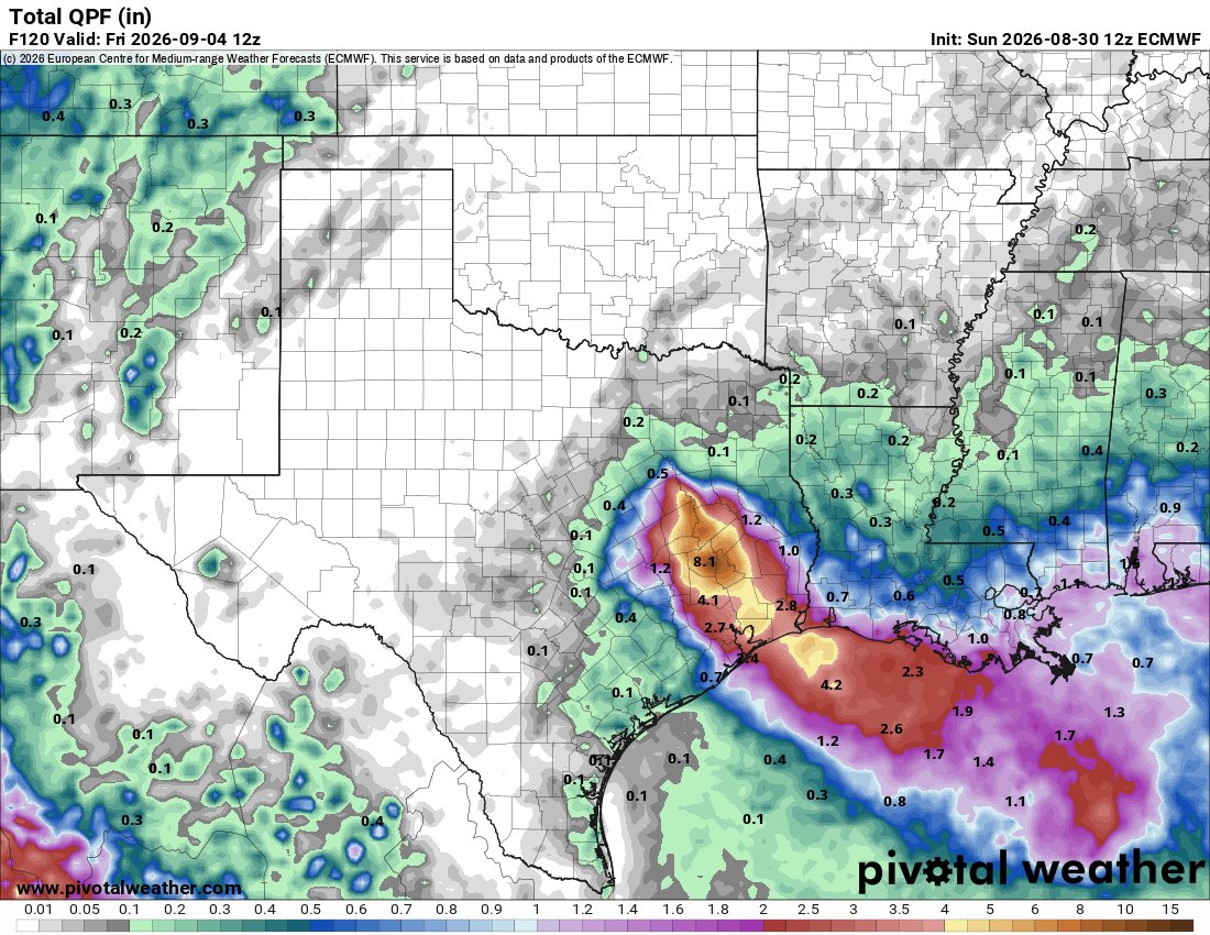
The 12z Euro gets some decent rain into parts of Texas.


Posted on 8/30/26 at 3:22 pm to rds dc
quote:
The 12z Euro gets some decent rain into parts of Texas.
:rummy:
Posted on 8/30/26 at 3:30 pm to rds dc
4.1 sitting right over my house. excellent.
Posted on 8/30/26 at 4:24 pm to rds dc
Levi’s latest
Posted on 8/30/26 at 4:34 pm to Clockwatcher68
Best not to do that. Labor Day weekend will say “hold my beer.”
Posted on 8/30/26 at 4:39 pm to rds dc
College Station is jealous because the folks a little bit East are getting 8 inches.


Posted on 8/30/26 at 4:47 pm to rds dc
Dolly maybe a problem
Posted on 8/30/26 at 5:30 pm to rds dc
Looks like a dick going right into Houston


Posted on 8/30/26 at 5:56 pm to rds dc
quote:
The 12z Euro gets some decent rain into parts of Texas.
Wouldn’t mind being on right around that 4-5” range
With my wife’s luck we will be on the .5” range
Posted on 8/30/26 at 6:15 pm to DiamondDog
WTF dude, let’s get through September before we count our blessings


Posted on 8/30/26 at 6:24 pm to SWLA92
El Niño bro
Do you even?!?
Do you even?!?
Posted on 8/30/26 at 6:28 pm to SWLA92
quote:
WTF dude, let’s get through September before we count our blessings
I think it was a troll
Posted on 8/30/26 at 6:57 pm to Cosmo
Northern Gulf of America (AL97):
An area of low pressure located over the northern Gulf of America,
about 125 miles south of the coast of southeastern Louisiana,
continues to become better defined, and the associated shower and
thunderstorm activity is gradually increasing. Continued gradual
development is expected as the low moves slowly west-northwestward,
and a short-lived tropical depression or tropical storm is likely to
form before the system reaches the Upper Texas or southwestern
Louisiana coasts on Tuesday or Tuesday night.
Interests along the southwest Louisiana and Upper Texas coasts
should monitor the progress of this system, as tropical storm
watches or warnings could be required for portions of the area later
tonight or Monday morning. Regardless of development, this system is
expected to bring locally heavy rainfall to portions of the Upper
Texas and southwestern Louisiana coasts during the next several
days. An Air Force Reserve reconnaissance aircraft is scheduled to
investigate the low-pressure area on Monday morning.
* Formation chance through 48 hours...high...70 percent.
* Formation chance through 7 days...high...70 percent.
An area of low pressure located over the northern Gulf of America,
about 125 miles south of the coast of southeastern Louisiana,
continues to become better defined, and the associated shower and
thunderstorm activity is gradually increasing. Continued gradual
development is expected as the low moves slowly west-northwestward,
and a short-lived tropical depression or tropical storm is likely to
form before the system reaches the Upper Texas or southwestern
Louisiana coasts on Tuesday or Tuesday night.
Interests along the southwest Louisiana and Upper Texas coasts
should monitor the progress of this system, as tropical storm
watches or warnings could be required for portions of the area later
tonight or Monday morning. Regardless of development, this system is
expected to bring locally heavy rainfall to portions of the Upper
Texas and southwestern Louisiana coasts during the next several
days. An Air Force Reserve reconnaissance aircraft is scheduled to
investigate the low-pressure area on Monday morning.
* Formation chance through 48 hours...high...70 percent.
* Formation chance through 7 days...high...70 percent.

Posted on 8/30/26 at 7:34 pm to lsuman25
Rumor that Dolly might not be dead yet?
Hopefully that’s just some nonsense
Hopefully that’s just some nonsense

Posted on 8/30/26 at 8:37 pm to questionable
quote:
those people have been through enough.

Posted on 8/30/26 at 9:41 pm to DiamondDog
Please stfu and log off baw

 Page 3 of 5

Popular
Back to top
 Follow TigerDroppings for LSU Football News