- My Forums
- Tiger Rant
- LSU Recruiting
- SEC Rant
- Saints Talk
- Pelicans Talk
- More Sports Board
- Fantasy Sports
- Golf Board
- Soccer Board
- O-T Lounge
- Tech Board
- Home/Garden Board
- Outdoor Board
- Health/Fitness Board
- Movie/TV Board
- Book Board
- Music Board
- Political Talk
- Money Talk
- Fark Board
- Gaming Board
- Travel Board
- Food/Drink Board
- Ticket Exchange
- TD Help Board
Customize My Forums- View All Forums
- Show Left Links
- Topic Sort Options
- Trending Topics
- Recent Topics
- Active Topics
Started By
Message
 1
1

Posted on 3/24/23 at 5:53 pm to deltaland
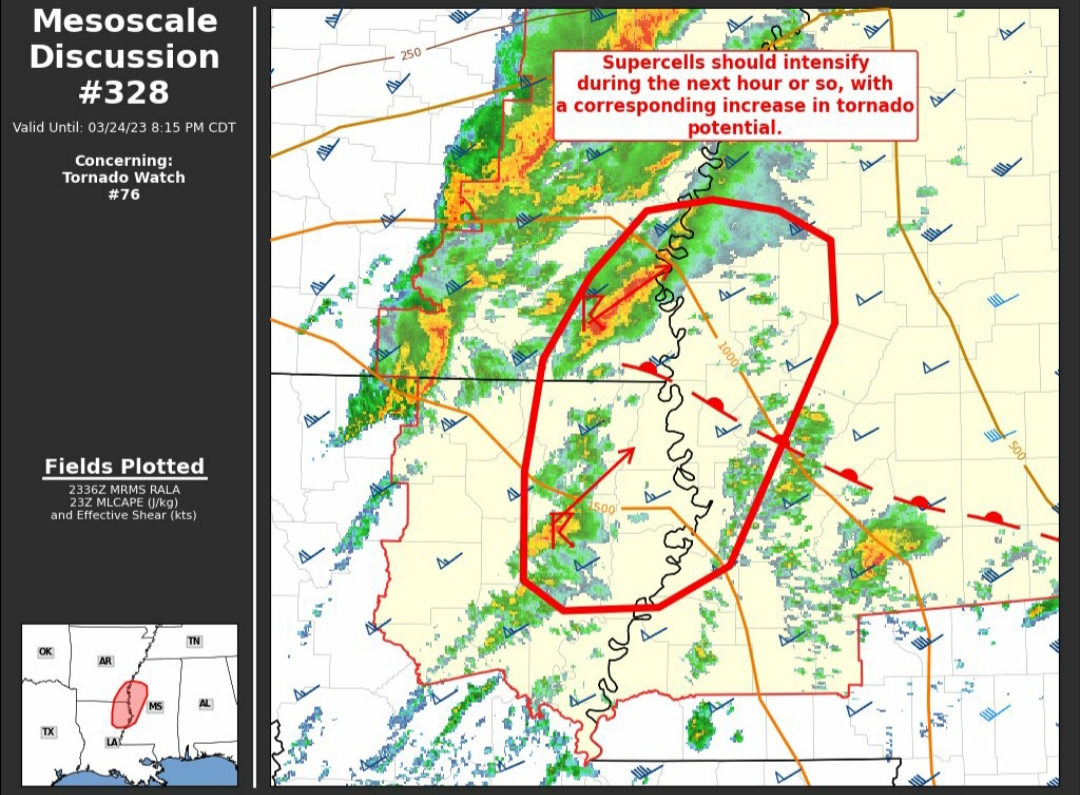
The probabilities for the tornado watch issued along the MS River are just below PDS criteria.
This post was edited on 3/24/23 at 5:54 pm
Posted on 3/24/23 at 5:59 pm to Champagne
It just depends on the year/pattern but I know last year was on a 7 day schedule damn near on a clock
Posted on 3/24/23 at 6:14 pm to Wishnitwas1998
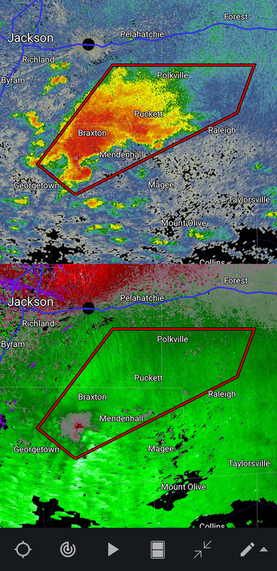
Cell south of Jackson just caught a warning.
Posted on 3/24/23 at 6:32 pm to LegendInMyMind
Cell near Winnsboro, La is one to watch.
Posted on 3/24/23 at 6:38 pm to deltaland
Is that mess of warned storms going to go north of you?

Posted on 3/24/23 at 6:43 pm to LegendInMyMind
Yeah that storm southeast of Jackson is nasty.
Posted on 3/24/23 at 6:45 pm to Roll Tide Ravens
Looks like it may be getting close to putting one down. It has been trying for a while.
Posted on 3/24/23 at 6:58 pm to LegendInMyMind
quote:
Is that mess of warned storms going to go north of you?
Yes.
Really not a whole lot out there nothing south of Arkansas state line seems to be holding together besides that one cell east of Jackson. All the convection within the moderate area is pretty much meh.
Watch, these small cells in west MS will blow up later in east Ms and west Al. Always do. North La starting to look like a complete bust
ETA saying that seems the worst stuff is trending more north so far but it is still early. I expected it to be worse farther south like north La and Jackson north to hwy 82
This post was edited on 3/24/23 at 7:04 pm
Posted on 3/24/23 at 7:01 pm to LegendInMyMind
Looking at that map that Delhi cell would track close to me. I’m in south sunflower county about 6 miles north of Humphreys county line. Inverness, Ms
This post was edited on 3/24/23 at 7:04 pm
Posted on 3/24/23 at 7:22 pm to deltaland
If we see any of these cells take off it will be because the LLJ has kicked in. There seems to be some issues with shear in the mid levels that is working against mesos being able to build and sustain themselves. The LLJ has been delayed on models this entire time. Now, it may be delayed and a bit misplaced to help these storms get going. That said, I worry about the line as it moves east and that jet does crank. That's what has led to the expansion of the Enhanced area earlier today. It is wind-driven, mostly, but with the shear already in place and a boost from the jet, that line worries me a bit.....especially being that it will come through in the dead of night.
The bowing segment of the line that has been consistent on CAMs up in north AL tonight/early morning has a chance to bring big winds with it if it develops that way.
The bowing segment of the line that has been consistent on CAMs up in north AL tonight/early morning has a chance to bring big winds with it if it develops that way.
Posted on 3/24/23 at 7:24 pm to LegendInMyMind
That's a nasty bit of line up near Osceola and Blytheville.
Posted on 3/24/23 at 7:29 pm to LegendInMyMind
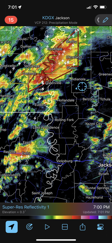
Cleveland ms about to get hammered I hope that warned area doesn’t drop a tornado it doesn’t appear to have one at the moment. It’s headed right for delta state campus
Posted on 3/24/23 at 7:38 pm to LegendInMyMind
Lake Providence cell could be a problem for me it will track right over me
Posted on 3/24/23 at 7:47 pm to deltaland
It’s warned now
Posted on 3/24/23 at 7:59 pm to WylieTiger
Some semi discreet stuff trying to fire now

Posted on 3/24/23 at 7:59 pm to WylieTiger
Take cover

Posted on 3/24/23 at 8:00 pm to Bobby OG Johnson


 Page 6 of 32

Popular
Back to top