- My Forums
- Tiger Rant
- LSU Recruiting
- SEC Rant
- Saints Talk
- Pelicans Talk
- More Sports Board
- Fantasy Sports
- Golf Board
- Soccer Board
- O-T Lounge
- Tech Board
- Home/Garden Board
- Outdoor Board
- Health/Fitness Board
- Movie/TV Board
- Book Board
- Music Board
- Political Talk
- Money Talk
- Fark Board
- Gaming Board
- Travel Board
- Food/Drink Board
- Ticket Exchange
- TD Help Board
Customize My Forums- View All Forums
- Show Left Links
- Topic Sort Options
- Trending Topics
- Recent Topics
- Active Topics
Started By
Message
re: Multi-day Severe Weather Threat: 3/23-3/24
Posted on 3/26/23 at 4:33 am to LegendInMyMind
Posted on 3/26/23 at 4:33 am to LegendInMyMind
We've got some storms moving through my area for the last couple of hours. Not really much wind or rain, but there's been a crapload of lightning.
 0
0


Posted on 3/26/23 at 5:57 am to LegendInMyMind
Posted on 3/26/23 at 6:05 am to Bobby OG Johnson


Posted on 3/26/23 at 6:57 am to Bobby OG Johnson
upcoming week doesn't look good.
Posted on 3/26/23 at 7:25 am to Bobby OG Johnson
quote:
Jennifer Watson
@JWatson_Wx
·
22m
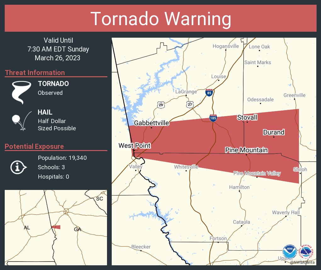
According local EMA - multiple injuries reported from the #tornado that moved south of #LaGrange this morning in #Georgia. Reports of homes leveled and closure of parts of highways I-85 and 185 closed due to trees and damage.

Posted on 3/26/23 at 7:38 am to Bobby OG Johnson
We were spared yesterday. Storms north and south of us. SW Georgia.
Posted on 3/26/23 at 7:49 am to themunch
quote:
atlantanewsfirst.com
Tiger on the loose at Pine Mountain Animal Safari in Troup County
The Troup County Sheriff’s Office says the animal is “unaccounted inside the park.”
Posted on 3/26/23 at 9:11 am to Bobby OG Johnson
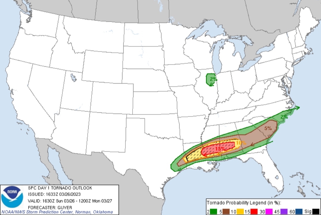
Large Tornado and Hail areas for today
Everyone out there stay safe!


Everyone out there stay safe!
This post was edited on 3/26/23 at 9:12 am
Posted on 3/26/23 at 10:44 am to Bobby OG Johnson
quote:
atlantanewsfirst.com
Tiger on the loose at Pine Mountain Animal Safari in Troup County
The Troup County Sheriff’s Office says the animal is “unaccounted inside the park.”
They got it.
Posted on 3/26/23 at 11:46 am to SteelerBravesDawg
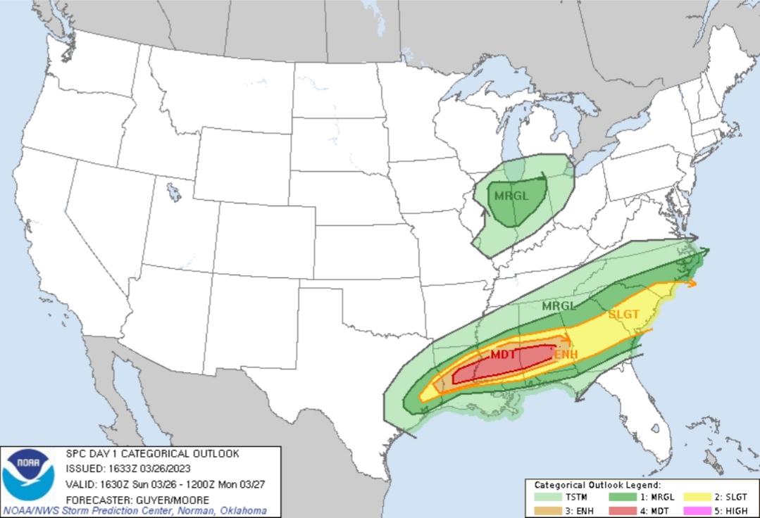
Got the upgrade to Moderate:
45% Hatched for large hail:
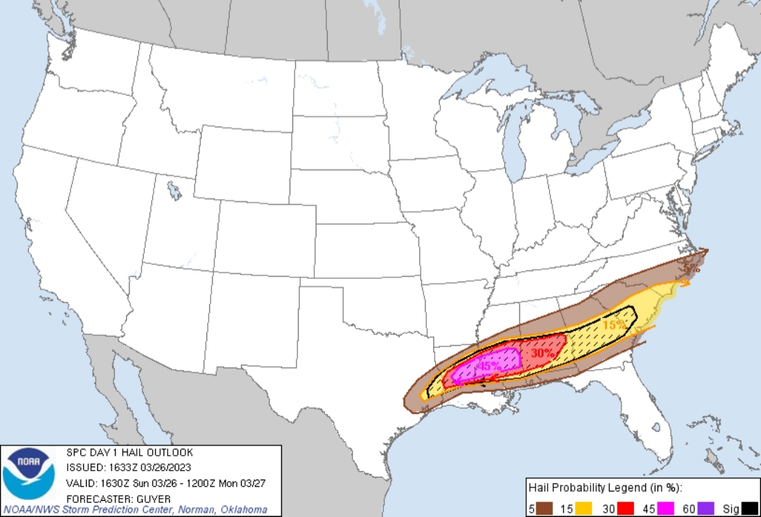
Definitely find some covered parking if you're in the pink and red area.
45% Hatched for large hail:
Definitely find some covered parking if you're in the pink and red area.
This post was edited on 3/26/23 at 11:50 am
Posted on 3/26/23 at 11:56 am to LegendInMyMind
quote:
SPC AC 261633
Day 1 Convective Outlook NWS Storm Prediction Center Norman OK 1133 AM CDT Sun Mar 26 2023
Valid 261630Z - 271200Z
...THERE IS A MODERATE RISK OF SEVERE THUNDERSTORMS ACROSS PORTIONS OF LOUISIANA/MISSISSIPPI/ALABAMA...
...SUMMARY... Episodic severe thunderstorms will persist into tonight across a broad portion of the Deep South/Southeast States. A few strong tornadoes and very large hail may occur with the most intense storms, particularly from central Louisiana across central/southern portions of Mississippi and Alabama this afternoon and evening.
...Deep South/Southeast... Some severe potential, mostly in the form of hail/wind, may continue early this afternoon across the South Carolina Piedmont/southern North Carolina. This environment also remains conditionally favorable for a few severe storms to the west across southeast Mississippi, south-central Alabama, into west-central Georgia near the effective front. This sub-regional corridor may be experiencing a bout of shortwave ridging, but that at the same time, the boundary layer will continue to diurnally destabilize.
Focus then quickly turns farther west to the potential for deep convective development along the northward-shifting boundary from east/southeast Texas into Louisiana, which could potentially occur relatively early, during early/mid-afternoon. See Mesoscale Discussion 354 for more short-term details. Low-level shear/SRH will not initially be strong but strengthen through late afternoon/early evening as 850mb/1-2 km AGL winds increase and low-level hodographs enlarge. Storms, including initially semi-discrete/intense supercells, will tend to cluster/gradually grow upscale along the boundary with hail/wind potential, but an increased concern for tornadoes, some of which may be strong/intense (EF2+), would exist with supercells that evolve/persist in a semi-discrete manner south of the boundary and move into and/or develop across south-central/southeast Mississippi, and eventually southwest/southern Alabama this evening as 850mb/1-2 km AGL winds further intensify.
...Illinois/Indiana... Low-topped thunderstorms are expected to develop this afternoon across eastern/northeast Illinois as a low-amplitude shortwave trough overspreads this region. Although low-level moisture should remain limited, enough weak instability should still develop through the day as mid-level temperatures cool with the shortwave trough passage. With some enhanced low/mid-level flow forecast, any convection that can develop and be sustained may pose an isolated damaging wind risk, and perhaps a brief tornado across north-central/northeast Illinois.
..Guyer/Moore.. 03/26/2023
CLICK TO GET WUUS01 PTSDY1 PRODUCT
NOTE: THE NEXT DAY 1 OUTLOOK IS SCHEDULED BY 2000Z

Posted on 3/26/23 at 12:06 pm to LegendInMyMind
Because of the Troup county tornado this morning, none of our media is talking about the rest of the storms- the radar this morning over middle GA had white blobs in them, you know the scale that goes from light green to green to yellow to red to dark red to brown then to purple then to white? I've never seen radar actually get to white before today. Any weather reports of crazy hail out there for those storms this morning and today?
Posted on 3/26/23 at 12:08 pm to deeprig9
quote:
Any weather reports of crazy hail out there for those storms this morning and today?
Definitely reports of crazy hail for this part of the country. I've seen ping pong ball size and a little larger.
This post was edited on 3/26/23 at 12:09 pm
Posted on 3/26/23 at 12:09 pm to LegendInMyMind
What’s keeping the severe threat in such a narrow corridor and not expanding north?
Clear skies and almost 80 degrees here
Clear skies and almost 80 degrees here
Posted on 3/26/23 at 12:12 pm to deltaland
quote:
What’s keeping the severe threat in such a narrow corridor and not expanding north?
The boundary that is acting as forcing. Not much farther North to fire storms. And a little shortwave working through the area.
This post was edited on 3/26/23 at 12:13 pm
Posted on 3/26/23 at 12:57 pm to LegendInMyMind
Posted on 3/26/23 at 1:01 pm to lsuman25
Keep an eye on that cell west of Montgomery, Al
Posted on 3/26/23 at 1:35 pm to deltaland
It is likely going to be a bit before we see the tornado threat maximize and see storms really start to wrap up. Current shear is on the weak side, but we have really high instability (CAPE) in place. That's why the early storms will favor, potentially, very large hail.
Later, when the mid-level winds ramp up a bit with the LLJ increasing across the area shear will be more favorable for rotating updrafts and tornadoes.
Later, when the mid-level winds ramp up a bit with the LLJ increasing across the area shear will be more favorable for rotating updrafts and tornadoes.

Posted on 3/26/23 at 1:59 pm to LegendInMyMind
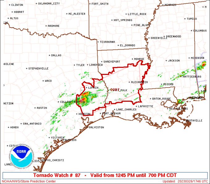
Big hailer south of Sherevport
Posted on 3/26/23 at 2:16 pm to The Boat
Just saw it. Warned for golf balls.

 Page 25 of 32

Popular
Back to top