- My Forums
- Tiger Rant
- LSU Recruiting
- SEC Rant
- Saints Talk
- Pelicans Talk
- More Sports Board
- Coaching Changes
- Fantasy Sports
- Golf Board
- Soccer Board
- O-T Lounge
- Tech Board
- Home/Garden Board
- Outdoor Board
- Health/Fitness Board
- Movie/TV Board
- Book Board
- Music Board
- Political Talk
- Money Talk
- Fark Board
- Gaming Board
- Travel Board
- Food/Drink Board
- Ticket Exchange
- TD Help Board
Customize My Forums- View All Forums
- Show Left Links
- Topic Sort Options
- Trending Topics
- Recent Topics
- Active Topics
Started By
Message
re: Multi-day Severe Weather Threat: 3/23-3/24
Posted on 3/25/23 at 6:00 pm to Roll Tide Ravens
Posted on 3/25/23 at 6:00 pm to Roll Tide Ravens
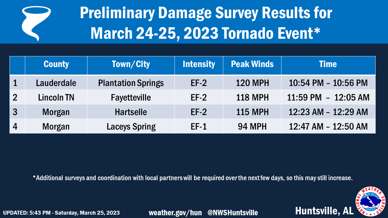
The Fayetteville, TN tornado has been confirmed as an EF2.
 1
1


Posted on 3/25/23 at 6:07 pm to LegendInMyMind
Legend…… Mother Nature sure is pissed off the last couple days. And then sun-mon-tues looks like even more bad crap.
The photos I’ve seen in Miss are horrific.
The photos I’ve seen in Miss are horrific.
Posted on 3/25/23 at 6:13 pm to dukke v

Posted on 3/25/23 at 7:05 pm to lockthevaught
Posted on 3/25/23 at 7:47 pm to LegendInMyMind
Thank you
Posted on 3/25/23 at 7:49 pm to lockthevaught
quote:
This damage in Amory MS is nucking futs
They got it bad but to be honest it could’ve been even worse, the storm tracked somewhat NW of town from what it looked like on radar or it would look more like Rolling Fork.
Posted on 3/25/23 at 7:55 pm to tide06
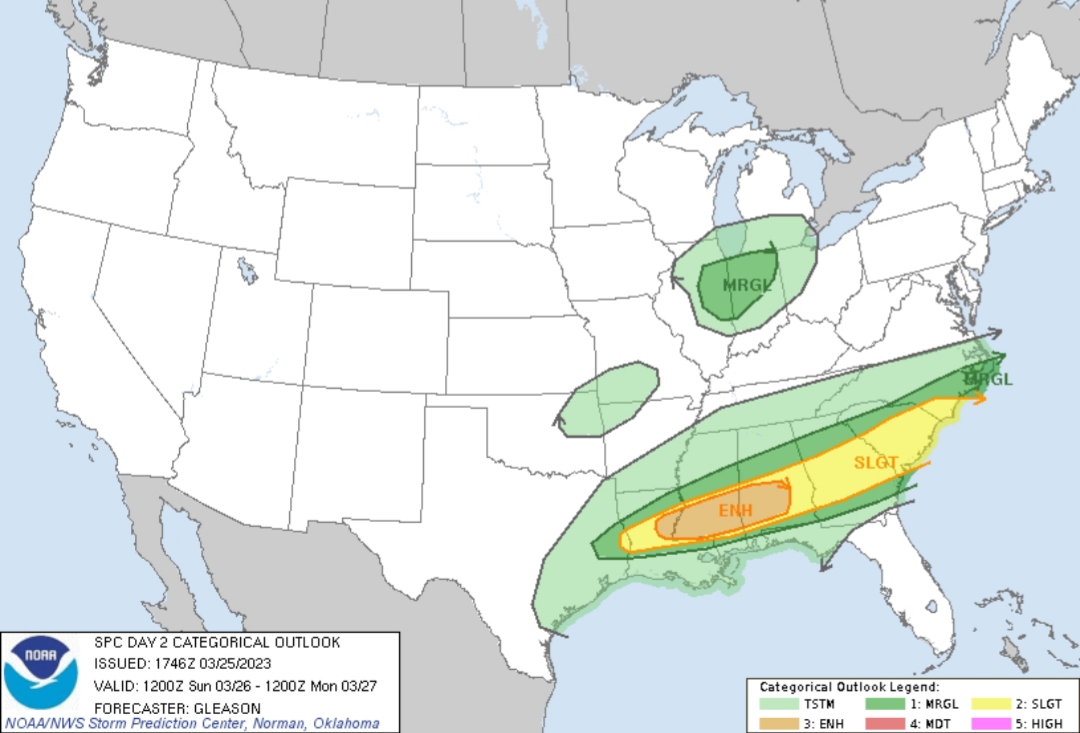
Looks like we have to do it again tomorrow:
I haven't looked into this one at all.
I haven't looked into this one at all.
Posted on 3/25/23 at 8:04 pm to LegendInMyMind
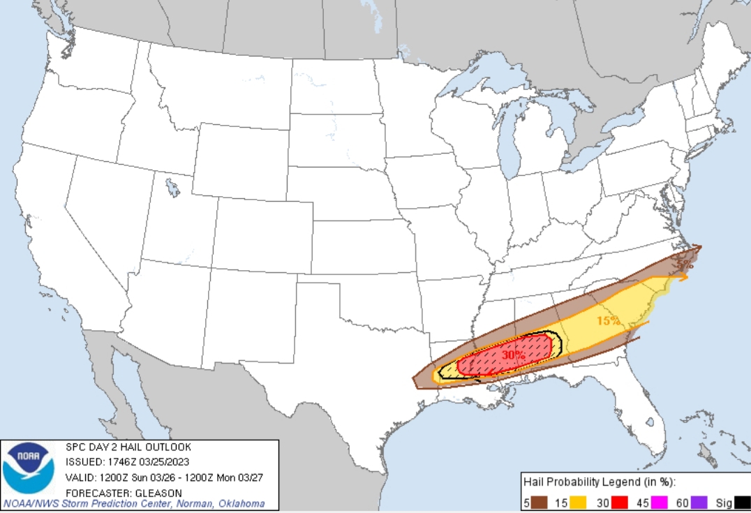
Not too often we see a 30% hatched in this area for severe hail, and at first glance....the soundings sure as hell support it.
If I'm anywhere in that area I believe I'd find some cover for my vehicles if I don't have it. Baton Rouge shouldn't discredit the hail threat, as storms develop in SW LA around Lake Chuck initially and track ENE with activity developing farther North.
This post was edited on 3/25/23 at 8:05 pm

Posted on 3/25/23 at 8:09 pm to WestSideTiger
quote:Wow, the moment the new scan comes in you can see the reality of the situation hit him. Then the instant prayer on air. Awful.
WATCH: WTVA meteorologist Matt Laubhan overwhelmed as major tornado hits Amory, Mississippi
This post was edited on 3/25/23 at 8:11 pm

Posted on 3/25/23 at 8:15 pm to Lsuhoohoo


Posted on 3/25/23 at 8:33 pm to lockthevaught
quote:
This damage in Amory MS is nucking futs Youtube Link
Nautic star factory is trashed, sounds like Avid next door suffered pretty bad damage as well.
Posted on 3/25/23 at 8:45 pm to Roll Tide Ravens
24 hour time lapse

Posted on 3/25/23 at 8:46 pm to Roll Tide Ravens
I knew there was no way the rolling fork tornado would be less than EF4. You don’t see total destruction like that with less than a strong EF3
Posted on 3/25/23 at 8:49 pm to Roll Tide Ravens
I will say the one positive thing you see in these events is the way communities come together. I saw wealthy white farmers with equipment helping and working side by side with a bunch of poor black folk clearing neighborhoods no matter what part of town it was. Just people helping each other. Take the politics and shite out of the world and you just have people there helping one another lifting each other up. No looting. No ignoring people needing help because they aren’t “your people.”
Granted small towns are different but it really shows how the world could be if we could eliminate the division bullshite the media and people with agendas push on regular Americans
Granted small towns are different but it really shows how the world could be if we could eliminate the division bullshite the media and people with agendas push on regular Americans
Posted on 3/25/23 at 9:04 pm to Bobby OG Johnson
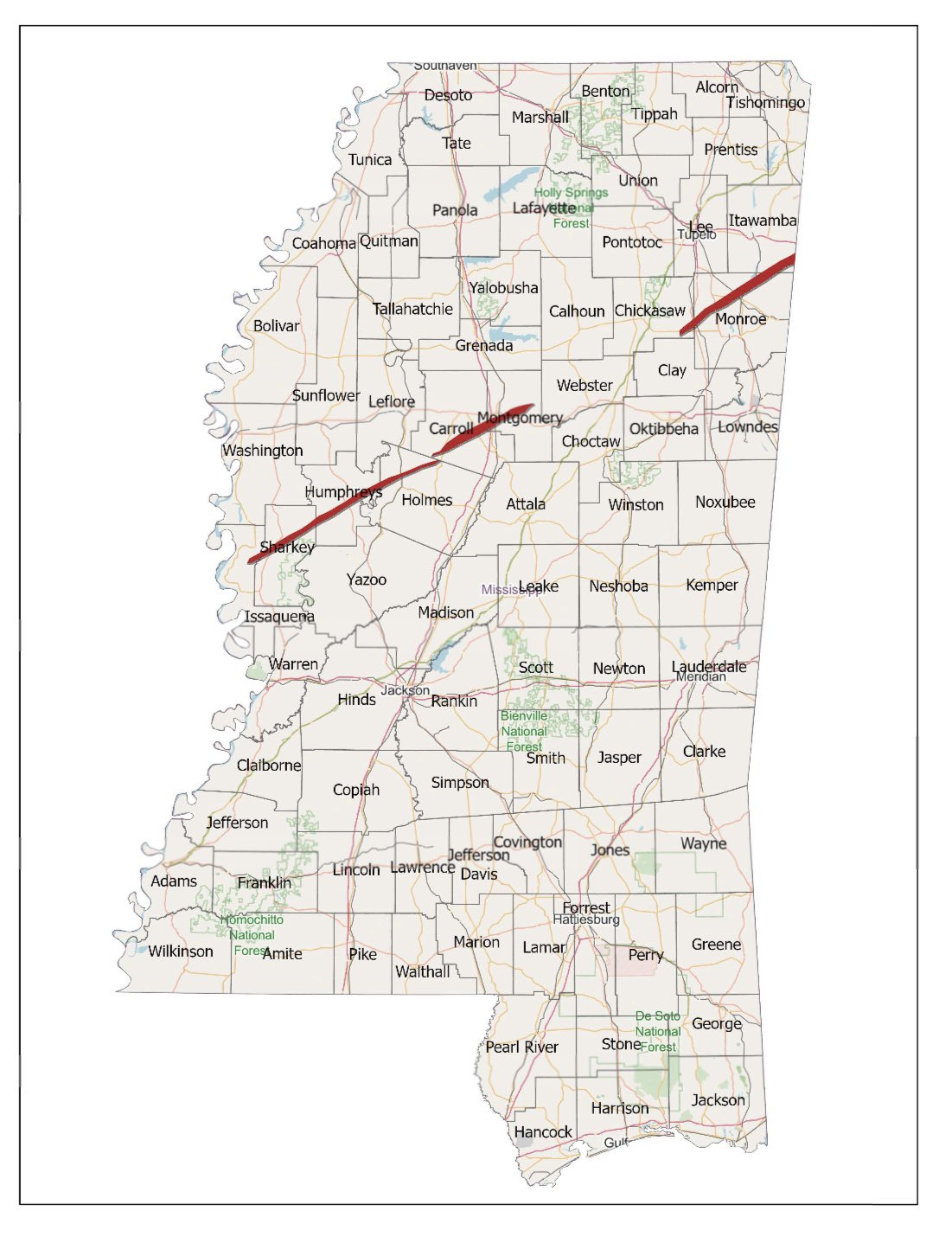
Track map from MSEMA
Posted on 3/25/23 at 9:10 pm to Bobby OG Johnson
The HRRR Updraft Helicity Swath product did a pretty good job of sniffing out most of the tornadic storms. It wavered some with intensity, but never got off of the right area.
Posted on 3/26/23 at 1:23 am to LegendInMyMind
 10% with hatching for Tornadoes now.
This post was edited on 3/26/23 at 1:27 am
Posted on 3/26/23 at 1:25 am to lsuman25
..THERE IS AN ENHANCED RISK OF SEVERE THUNDERSTORMS PARTS OF
EASTERN LOUISIANA THROUGH SOUTHERN MISSISSIPPI AND INTO SOUTHERN
ALABAMA...
...SUMMARY...
Scattered severe thunderstorms will likely occur from central
Louisiana eastward across the central Gulf Coast states and into the
Carolinas. Several tornadoes are possible, including the
possibility for a couple of strong tornadoes. A risk for large to
very large hail will probably accompany the more intense storms.
...Synopsis...
A belt of strong west-southwesterly mid-level flow will extend from
the Desert Southwest eastward across the lower MS Valley and into
the Carolinas/Mid-Atlantic states. A larger-scale trough initially
over the Interior West will deamplify as a 90-kt 500 mb speed max
moves from AZ/NM to the lower OH Valley. A lower-latitude mid-level
perturbation is forecast to move from south-central/east-central TX
to MS/AL by early evening. In the low levels, a frontal zone
initially draped from southern LA through central AL will probably
advance northward into northern LA and central MS during the day as
a weak area of low pressure develops east along the frontal zone
coincident with the mid-level speed max.
...Central Gulf Coast east to the Carolinas...
A cluster of thunderstorms may be ongoing this morning over parts of
AL/GA via low-level warm-air advection and an accompanying isolated
risk for severe thunderstorms. Model guidance seems to indicate
that this activity will persist and move east while some upscale
growth occurs during the morning. Strong effective shear (50 kt)
will support storm organization. Less certain is the evolution of
this potential storm activity as it evolves through the diurnal
heating cycle as it moves across GA into the Carolinas. Additional
storms may develop with some of these becoming supercellular while a
complex mixed convective mode (perhaps downscale growth into some
cells) may occur. Regardless, all hazards seem possible given the
ample buoyancy (500-2000 J/kg MLCAPE) forecast across parts of GA
into the Carolinas during the day.
Farther west, as the marine warm front advances slowly northward
into the lower MS Valley and south-central AL during the day, the
combination of heating and moistening of the boundary layer beneath
steep 700-500 mb lapse rates will result in a corridor of moderate
to strong buoyancy (1500-3000 J/kg MLCAPE). A gradual veering and
strengthening of flow with height will result in enlarging and long
hodographs by late afternoon/early evening. A seemingly potent
thermodynamic/kinematic setup is shown by some models from LA east
into AL. The favorable timing of the mid-level disturbance and an
intensification of the 850-mb flow will conditionally yield a
potentially very favorable corridor for intense supercells.
Isolated to scattered thunderstorms will likely develop during the
afternoon into the evening. Large to very large hail is possible
with the stronger updrafts and several tornadoes are also possible,
including a risk for a couple of strong tornadoes. A cluster of
storms will likely evolve as a LLJ intensifies by the mid-late
evening and into the overnight with a severe risk spreading east.
...IL/IN...
Low-topped thunderstorms may develop Sunday afternoon across eastern
IL as a low-amplitude shortwave trough overspreads this region.
Although low-level moisture should remain limited, enough weak
instability may still develop through the day as mid-level
temperatures cool with the shortwave trough passage. With some
enhanced low/mid-level flow forecast, and convection that can
develop and be sustained may pose an isolated damaging wind risk.
Posted on 3/26/23 at 3:27 am to lsuman25
Multiple severe thunderstorm watches from Mississippi into Georgia early this morning (posting this around 3:30 am). Numerous ongoing severe thunderstorm warnings.

Posted on 3/26/23 at 4:20 am to Roll Tide Ravens
We've had hurricane force winds, a full day of 40+mph wind, and multiple tornado warnings and severe storm warnings over the past month and didn't lose power. We just had one random arse, sub-severe storm pop up with a handful of lightning strikes and now the power is out.
The thunder was loud enough to wake me up, though. So, there's that.
The thunder was loud enough to wake me up, though. So, there's that.
This post was edited on 3/26/23 at 4:21 am

 Page 24 of 32

Popular
Back to top