- My Forums
- Tiger Rant
- LSU Recruiting
- SEC Rant
- Saints Talk
- Pelicans Talk
- More Sports Board
- Fantasy Sports
- Golf Board
- Soccer Board
- O-T Lounge
- Tech Board
- Home/Garden Board
- Outdoor Board
- Health/Fitness Board
- Movie/TV Board
- Book Board
- Music Board
- Political Talk
- Money Talk
- Fark Board
- Gaming Board
- Travel Board
- Food/Drink Board
- Ticket Exchange
- TD Help Board
Customize My Forums- View All Forums
- Show Left Links
- Topic Sort Options
- Trending Topics
- Recent Topics
- Active Topics
Started By
Message
re: Major Severe Weather Outbreak: March 14-16, 2025
Posted on 3/16/25 at 6:47 pm to rt3
Posted on 3/16/25 at 6:47 pm to rt3
Loading Twitter/X Embed...
If tweet fails to load, click here.This post was edited on 3/16/25 at 6:48 pm
 1
1

Posted on 3/16/25 at 6:51 pm to rt3
quote:
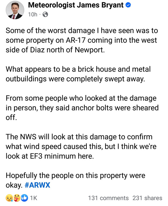
If I'm correct, the Diaz, Arkansas tornado is the first tornado to receive a preliminary EF-4/190mph rating right off the bat since the 05/20/2013 Moore, Oklahoma EF-5. They are both now the only tornadoes in NWS history to have that happen.
This is only true if you ignore 4/27/11. Smithville got a 190mph prelim rating. It was upgraded a day later to an EF5.
quote:
..PRELIMINARY EF-4 TORNADO IN MONROE COUNTY MISSISSIPPI
SMITHVILLE TORNADO
* COUNTY/COUNTIES: MONROE
* LOCATION/TIME OF EVENT: DAMAGE AT SMITHVILLE 344 PM CDT
* BEGINNING POINT: UNKNOWN
* ENDING POINT: UNKNOWN
* RATING: EF-4
* ESTIMATED PEAK WIND: 190 MPH
* PATH LENGTH: UNKNOWN
* MAXIMUM WIDTH: 1/2 MILE
* FATALITIES: 13...5 STILL MISSING
* INJURIES: 40
* SUMMARY OF DAMAGES: DOZENS NEWLY CONSTRUCTED TWO STORY FULLY
BRICK HOMES LEVELED. TREES DEBARKED. PROFESSIONAL BUILDINGS DESTROYED.
A MAJOR CONTRIBUTION TO THE SUCCESS OF OUR SEVERE WEATHER WARNING
PROGRAM IS THE RECEIPT OF STORM REPORTS FROM ALL OUR CUSTOMERS AND
PARTNERS ACROSS THE MIDSOUTH. IF YOU WITNESSED OR ARE AWARE OF
ANY STORM DAMAGE DUE TO HIGH WINDS OR TORNADOES...PLEASE CONTACT
YOUR LOCAL EMERGENCY MANAGEMENT OFFICE...OR FOLLOW THE LINK AT THE
TOP OF OUR WEB PAGE AT WEATHER.GOV/MEMPHIS.
I'm thinking there were others with a 190mph prelim that day. Hackleburg/Phil Campbell wasn't one of them. Rainsville maybe......maybe one of the other EF4s.
Posted on 3/16/25 at 6:53 pm to rt3
Posted on 3/16/25 at 6:55 pm to LegendInMyMind
quote:
This is only true if you ignore 4/27/11. Smithville got a 190mph prelim rating. It was upgraded a day later to an EF5.
It's likely the person who posted that just didn't remember that storm
Point being (which your storm reinforces)... getting a prelim EF4 with 190 mph winds may be a precursor to getting later upgraded to EF5
Posted on 3/16/25 at 7:00 pm to LegendInMyMind
Is that a specially built safe room for that purpose or just a windowless room they called their safe room?
Posted on 3/16/25 at 7:04 pm to rt3
Posted on 3/16/25 at 7:22 pm to rt3
Posted on 3/16/25 at 7:36 pm to Jake88
quote:
Is that a specially built safe room for that purpose or just a windowless room they called their safe room?
I'm betting it is an actual safe room, purpose built. The roof didn't even come off of it, with the entire rest of the roof of the house gone.
I have neighbors who built a safe room closet when they were renovating and adding on to their home. Those rooms are legit, and built to high standards.
Posted on 3/16/25 at 7:42 pm to rt3
quote:
This was the most dangerous storm chasing day since El Reno 2013 I think
• Copic & Waelti nearly drove into a wedge then Waelti drove into a roof in the road
• Scholl was nearly hit by a tornado 2x
• McKinney was inside a tornado
• Hurley drove into big debris in the road
This is the type stuff that makes it easier for for people to advocate regulations for storm chasers. Last year was bad, and this year is starting out worse for the "chasing community". Sadly, I don't think anything will change until someone is killed.
Posted on 3/16/25 at 8:17 pm to Roll Tide Ravens
quote:
One idiot over in that thread said that there were “no alerts” in places like Arkansas and Missouri on Friday night.
This kind of stupid is special. I wish we had an IQ test that people had to pass to be able to post on these boards.
Posted on 3/16/25 at 9:46 pm to rt3
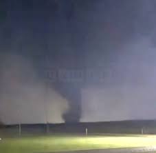
These are my better photos from my storm chasing experience between Collins and Seminary, MS


Posted on 3/16/25 at 9:54 pm to schwartzy
Preliminary rating of very high end EF4, this may end up being the strongest tornado of the outbreak.
Posted on 3/16/25 at 10:17 pm to SidewalkTiger
You know that shite is blowing when it tips over a dumptruck.
Posted on 3/16/25 at 10:23 pm to Turnblad85
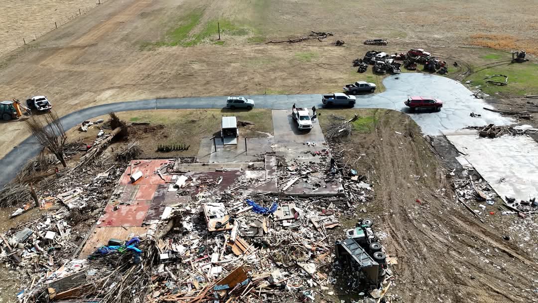
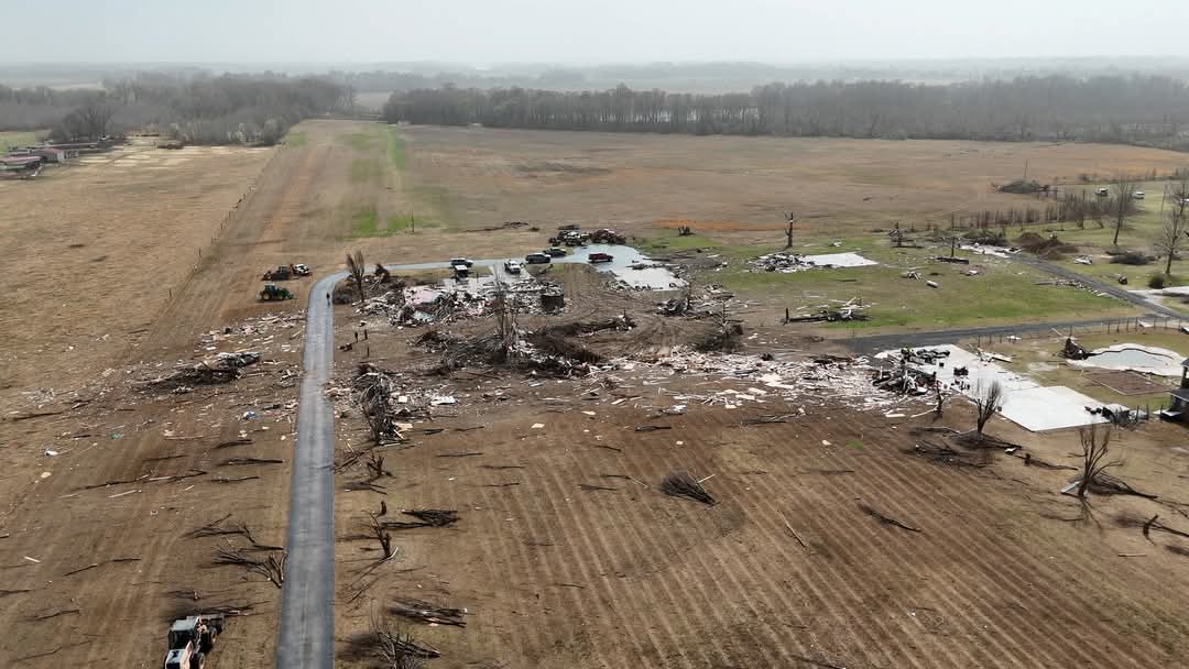
NWS Little Rock has confirmed EF4 damage in Izard County, AR so two EF-4's in Arkansas so far.
Posted on 3/16/25 at 10:34 pm to LegendInMyMind
All the EF-4 and EF-5 tornados I've followed since 1974 have been the dreaded wedge variety, except one: the infamous Jarrell tornado in Central Texas on May 27, 1997. That was a high-end EF-5 that was a rope which simply came out of nowhere thanks to a powerful Gravity Wave which set up shop in East Texas. The Jarrell Twister was a monster, killing 27 people in that one small town and anecdotally sucking people out of bathtubs!
Posted on 3/16/25 at 10:53 pm to tarzana
quote:
All the EF-4 and EF-5 tornados I've followed since 1974 have been the dreaded wedge variety,
I will, for a change, respectfully disagree with you on this. The term "wedge" has become so bastardized in the tornado chasing community that it is practically meaningless today. Everything is a wedge. That isn't the case, though. A "wedge" tornado has at least a somewhat accepted standard. The number of tornadoes that actually meet that standard is nowhere near what many make it seem. Believing that violent tornadoes only come in the "wedge" form is dangerous.

Posted on 3/16/25 at 11:10 pm to SidewalkTiger

Posted on 3/16/25 at 11:14 pm to Bobby OG Johnson
Where is the best place to find the ‘tracks’ of these tornados? Specifically the ones in tylertown
Posted on 3/16/25 at 11:16 pm to LegendInMyMind
Diaz, AR EF-4, may still be upgraded
Posted on 3/16/25 at 11:18 pm to Bobby OG Johnson
A LOT of EF-3's in this outbreak

 Page 85 of 88

Popular
Back to top