- My Forums
- Tiger Rant
- LSU Recruiting
- SEC Rant
- Saints Talk
- Pelicans Talk
- More Sports Board
- Fantasy Sports
- Golf Board
- Soccer Board
- O-T Lounge
- Tech Board
- Home/Garden Board
- Outdoor Board
- Health/Fitness Board
- Movie/TV Board
- Book Board
- Music Board
- Political Talk
- Money Talk
- Fark Board
- Gaming Board
- Travel Board
- Food/Drink Board
- Ticket Exchange
- TD Help Board
Customize My Forums- View All Forums
- Show Left Links
- Topic Sort Options
- Trending Topics
- Recent Topics
- Active Topics
Started By
Message
re: Major Severe Weather Outbreak: March 14-16, 2025
Posted on 3/15/25 at 3:14 pm to Roll Tide Ravens
Posted on 3/15/25 at 3:14 pm to Roll Tide Ravens
Still in Zone 3 but only 10 miles from Zone 4.
All of the west Metro Atlanta suburbs are in 4 including the western 3rd of Cobb and South Fulton, along with Rome, Dalton, and Columbus and Paulding County (where my MIL is)
All of the west Metro Atlanta suburbs are in 4 including the western 3rd of Cobb and South Fulton, along with Rome, Dalton, and Columbus and Paulding County (where my MIL is)
This post was edited on 3/15/25 at 3:19 pm
 1
1

Posted on 3/15/25 at 3:16 pm to LegendInMyMind
quote:
What are the womenses like in Chunky, MS?


Posted on 3/15/25 at 3:17 pm to Roll Tide Ravens
I’m actually getting a non-severe thunderstorm at my location north of Birmingham.
Posted on 3/15/25 at 3:18 pm to Jake88
quote:
How fine is the bottom of the tornado to do that? Why is there no crap strewn about the streets?
If you had read it was a wildfire.
Posted on 3/15/25 at 3:19 pm to Roll Tide Ravens
That's actually good, it'll stabilize the air somewhat.
Posted on 3/15/25 at 3:19 pm to Roll Tide Ravens
quote:
I’m actually getting a non-severe thunderstorm at my location north of Birmingham.
Same here to your north. It has really cooled our air.
Posted on 3/15/25 at 3:22 pm to im4LSU
Thanks boss, gave em the call and told them get in the bathroom.
Posted on 3/15/25 at 3:23 pm to LegendInMyMind
Temp has dropped 9° with the rain. 11° drop just to my west in the north central AL area.
Posted on 3/15/25 at 3:24 pm to LegendInMyMind
quote:
Same here to your north. It has really cooled our air.
Currently my temp is at 69 with a DP of 64. Hope it keeps going down.
Posted on 3/15/25 at 3:25 pm to LegendInMyMind
quote:
What are the womenses like in Chunky,MS?
Chunky is home to a place called Ma Shoemake's. You know how it is in a place where there are a couple of military bases in the area.
Posted on 3/15/25 at 3:25 pm to SteelerBravesDawg
quote:
Still in Zone 3 but only 10 miles from Zone 4.
I live up in Fort O. I think I’m fricked.
Posted on 3/15/25 at 3:25 pm to Roll Tide Ravens
New warning for the storm just SW of Tuscaloosa.
Posted on 3/15/25 at 3:26 pm to olemc999
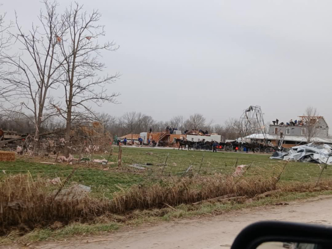
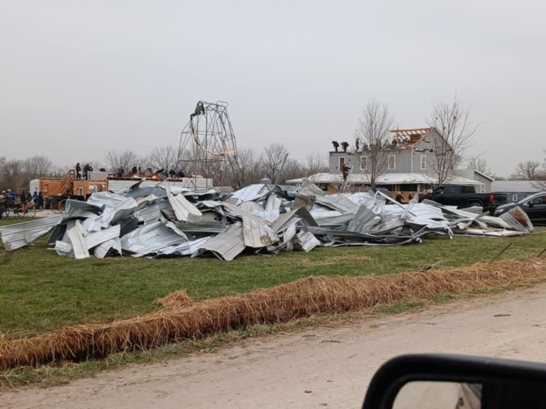
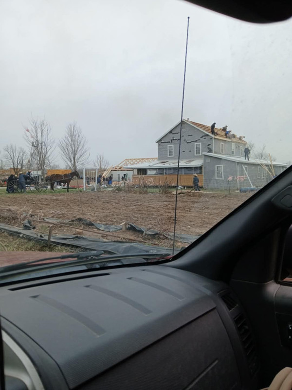
Not my photos but the Amish are already rebuilding from the tornado near Seymour, MO last night

Posted on 3/15/25 at 3:27 pm to MasterAbe1
quote:
Thanks boss, gave em the call and told them get in the bathroom.
You bet man.
Looks like it’s up around Collins now so they’re good…. for now
Posted on 3/15/25 at 3:27 pm to LegendInMyMind
That one is coming towards me now. We're about to get on the safe room.
Posted on 3/15/25 at 3:27 pm to Iron Lion
Tuscaloosa storm may have a confirmed tornado now.
This post was edited on 3/15/25 at 3:28 pm
Posted on 3/15/25 at 3:29 pm to im4LSU
I’ve had Hall’s stream up all day, that corridor between Tylertown and Bassfield has had me worried for them.
This post was edited on 3/15/25 at 3:29 pm
Posted on 3/15/25 at 3:31 pm to MasterAbe1
That storm is currently set to track just north of Tuscaloosa, but I would not be surprised to see it take a right turn.
Posted on 3/15/25 at 3:31 pm to LegendInMyMind
quote:
The National Weather Service in Birmingham has issued a
* Tornado Warning for... Northwestern Tuscaloosa County in west central Alabama...
* Until 430 PM CDT.
* At 324 PM CDT, a severe thunderstorm capable of producing a tornado was located over Benevola, or 12 miles east of Aliceville, moving northeast at 45 mph.
HAZARD...Tornado and quarter size hail.
SOURCE...Radar indicated rotation.
IMPACT...Flying debris will be dangerous to those caught without shelter. Mobile homes will be damaged or destroyed. Damage to roofs, windows, and vehicles will occur. Tree damage is likely.
* Locations impacted include... Whitson, Lake Tuscaloosa, Northport, Coker, Buhl, Windham Springs, Samantha, Flatwoods, Sexton Bend, Tierce Pattton Bridge, Lake Nicol, Wiley, Bankhead Lock And Dam, Echola, Lake Lurleen State Park, Highway 69 Bridge, Binion Creek Landing, Romulus, Lake Nicol Park, and Tuscaloosa Regional Airport.
Posted on 3/15/25 at 3:32 pm to LegendInMyMind
This one will ultimately come my general direction in northern Jefferson County if it continues on its current path.
This post was edited on 3/15/25 at 3:33 pm

 Page 60 of 88

Popular
Back to top