- My Forums
- Tiger Rant
- LSU Recruiting
- SEC Rant
- Saints Talk
- Pelicans Talk
- More Sports Board
- Fantasy Sports
- Golf Board
- Soccer Board
- O-T Lounge
- Tech Board
- Home/Garden Board
- Outdoor Board
- Health/Fitness Board
- Movie/TV Board
- Book Board
- Music Board
- Political Talk
- Money Talk
- Fark Board
- Gaming Board
- Travel Board
- Food/Drink Board
- Ticket Exchange
- TD Help Board
Customize My Forums- View All Forums
- Show Left Links
- Topic Sort Options
- Trending Topics
- Recent Topics
- Active Topics
Started By
Message
re: Major Louisiana Flood Event
Posted on 3/11/16 at 10:07 am to Chad504boy
Posted on 3/11/16 at 10:07 am to Chad504boy
There are going to be areas in western LA that break all-time river crest records by 5 feet or more. It is going to get alot worse in many areas even if it doesn't rain a drop.
This post was edited on 3/11/16 at 10:10 am
 1
1

Posted on 3/11/16 at 10:08 am to slackster
quote:
Hammond airport recorded 19.9 inches of rain overnight
From midnight to 7 am?
About 3 inches an hour. Possible but that seems more indicative of a storm overall total. They had six inches before the overnight round came in. That would put them at over 2' of rain thus far. Yeah, I bet that's 24 hour total.
This post was edited on 3/11/16 at 10:09 am
Posted on 3/11/16 at 10:14 am to TigerDog83
171 s to Stonewall to I 49 works fine for those heading South to Alex or BR. Thanks for the tip guys
Posted on 3/11/16 at 10:16 am to TheDiesel
My fiancees dad lives along the Sabine south of Toledo Bend.
It's crazy flooded down there right now.
It's crazy flooded down there right now.
Posted on 3/11/16 at 10:28 am to jdavid1


Posted on 3/11/16 at 10:31 am to cgrand
Radar is showing some pretty bad stuff coming for Nola

Posted on 3/11/16 at 10:33 am to cgrand
You should be fine. A friend of mine just went that way and was able to get down the service road on the south side of the interstate. It's still passable by the interstate, just not any further south.
Posted on 3/11/16 at 10:33 am to Large Farva
What radar are you using?
Posted on 3/11/16 at 10:34 am to Large Farva
Registers at the Manhattan Wal-Mart in Harvey are down. Trashy I know.
Posted on 3/11/16 at 10:35 am to burdman
TWC app. How do I post pictures of screenshots?
Posted on 3/11/16 at 10:37 am to Large Farva
Beats me 
Just wanted a reference because I'm supposed to be heading there later this afternoon
Just wanted a reference because I'm supposed to be heading there later this afternoon
Posted on 3/11/16 at 10:42 am to burdman


Posted on 3/11/16 at 10:43 am to Large Farva
Imgur app
Copy link and paste with img button
Thanks for making me type all that out for nothing!
Copy link and paste with img button
Thanks for making me type all that out for nothing!
This post was edited on 3/11/16 at 10:44 am
Posted on 3/11/16 at 10:43 am to Large Farva
Thanks

Posted on 3/11/16 at 10:44 am to Large Farva
Are you having relationship problems, Farva?

Posted on 3/11/16 at 10:45 am to burdman
So I'm looking to drive from Nola to Shreveport right now. Good idea or nah?
Posted on 3/11/16 at 10:45 am to Duke
It didn't start raining at airport road until late afternoon. Any totals were from about 5PM until now. According to the radar, more rain is on the way.
Posted on 3/11/16 at 10:46 am to Paige
Hahaha thank you. I just searched the help board to figure it out.
Posted on 3/11/16 at 10:47 am to TheDiesel
quote:
Yesterday someone was saying the Toledo Bend dam was vibrating. SRA update shows there is no damage to the dam and everything is operating fine
Yeah I've been watching that area quite a bit. The vibration apparently is to be expected when you've got all 9 gates opened at 22 ft, the highest they've ever been lifted (26 ft is maximum height). The press release from SRA is pretty ominous, especially the part about it not being a flood control reservoir. The record flooding that will happen downstream is sad, but if they don't release water from Toledo Bend and the dam fails, it would obviously be apocalyptic.
quote:
PRESS RELEASE March 10, 2016
Major Rains Cause Lower Sabine River Basin Flooding Event
(Orange, TX) According to the National Weather Service (NWS) more than 16 to 18 inches of rainfall has fallen over Toledo Bend Reservoir within the last three days with more rain expected. Toledo Bend Reservoir, operated by the Sabine River Authority of Texas and the Sabine River Authority, State of Louisiana reached a record level high of 174.36 feet mean sea level (msl) at 6:00 a.m. this morning due to the rainfall event. The current gauge reading is 174.20 feet msl at 3:00 p.m. today. Toledo Bend Reservoir is not a flood control reservoir and reaches full pool at 172.0 feet msl. Spillway gate releases, which protect the integrity of the dam, have reached a record of 207,644 cubic feet per second (cfs) which is 90,000 cfs over the previous record set in 1989. Currently 9 gates are open 22 feet and 1 generator is running 24 hours/day. There is no truth to the rumors that the Toledo Bend dam could break due to the record releases. The integrity of the dam is intact and is operating as designed.
quote:
Historic Crests
(1) 48.05 ft on 02/01/1999
(2) 47.45 ft on 05/20/1989
(3) 46.82 ft on 07/03/1989
(4) 45.90 ft on 05/01/1884
(5) 45.80 ft on 04/15/1945
48.05 The river has reached flood of record. Widespread major to catastrophic flooding occurs.
47 Major flooding occurs.
45 Moderate flooding occurs.
43 Residential flooding in the River Bend Subdivision occurs
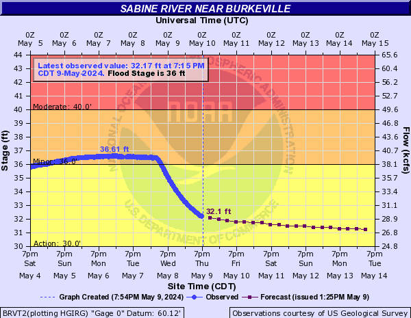
quote:
Historic Crests
(1) 43.50 ft on 04/23/1913
(2) 39.00 ft on 05/01/1884
(3) 38.70 ft on 05/19/1953
(4) 37.90 ft on 07/04/1989
(5) 37.73 ft on 05/23/1989
38.97 The river is at its flood of record. Widespread major to catastrophic flooding will occur.
36 Major lowland flooding will occur. Sabine Sands Road has about one to three feet of water covering the road.
35 Expect several secondary roads in the Merryville area near the river to be closed.
33 Moderate lowland flooding will occur. Low-lying roads and a few homes have some flooding between Bon Wier and Merryville. Camp houses along the river in Southwest Vernon Parish begin to flood.
32 Roads in the Sabine Sands area near Bon Wier become flooded.
30 Minor lowland flooding will occur along the river between Merryville and Bon Wier. A few roads in Southwest Vernon Parish have water over them

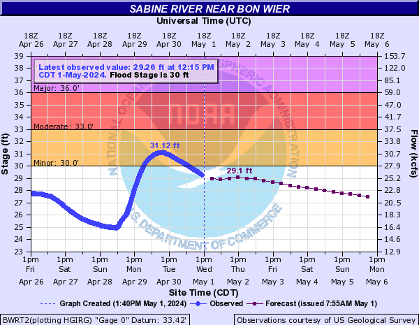
quote:
Historic Crests
(1) 32.20 ft on 05/01/1884
(2) 29.98 ft on 05/22/1953
(3) 29.50 ft on 04/29/1913
(4) 29.15 ft on 07/06/1989
(5) 29.10 ft on 08/01/1988
32.7 The river has reached its unofficial highest gage reading previously set in May 1884. Widespread catastrophic flooding will occur.
29.98 The river is at its flood of record. Widespread major to catastrophic flooding will occur.
29 Major flooing occurring leaving the town of Deweyville isolated. Numerous homes are flooded.
27.9 This flooding will be similar to the flooding expierenced in the flood of March 2001. Homes in Deweyville have water in them.
27 Widespread moderate lowland flooding will occur. Homes in Deweyville closest to the river are flooded. Flooding of homes in the Indian Lakes and River Oaks sections will also occur. Low-lying roads and a few homes in Southwest Beauregard Parish have some flooding.
26.8 Deweyville schools may be closed due to school bus routes being flooded.
26 Moderate lowland flooding will occur. The lowest homes between Deweyville and the river begin to flood, especially in the Indian Lakes and River Oaks sections. Low-lying roads and a few homes in Southwestern Beauregard Parish have some flooding.
25 Lowest roads beside the river flood around Deweyville and subject to being closed. In addition, low-lying roads in Southwest Beauregard Parish are flooded including Robert Clark Road. Flooding occurs on the south side of Niblett Bluff Park with access roads to camp houses cut off around the park. Access roads to the river in Northeastern Orange County become flooded.
quote:
Historic Crests
(1) 9.86 ft on 09/13/2008
(2) 6.27 ft on 04/25/1913
(3) 5.92 ft on 07/08/1989
(4) 5.77 ft on 08/23/1915
(5) 5.67 ft on 05/24/1953
9.86 Water levels are near those reached with the storm surge from Hurricane Ike in 2008. Widespread catastrophic flooding occurs across much of Orange. The Louisiana visitors center floods.
6 Major flooding can be expected. Numerous roads and homes in Orange are subject to flooding. Backwater flooding along Adams Bayou can be expected.
5 Moderate flooding can be expected along the river with some roads in Orange likely flooded. Back water flooding can also be expected along Adams Bayou in Orange.
4 Flooding of mainly secondary roads near the river can be expected. Steward Road may become impassable near the weigh station

 Page 58 of 102

Popular
Back to top