- My Forums
- Tiger Rant
- LSU Recruiting
- SEC Rant
- Saints Talk
- Pelicans Talk
- More Sports Board
- Fantasy Sports
- Golf Board
- Soccer Board
- O-T Lounge
- Tech Board
- Home/Garden Board
- Outdoor Board
- Health/Fitness Board
- Movie/TV Board
- Book Board
- Music Board
- Political Talk
- Money Talk
- Fark Board
- Gaming Board
- Travel Board
- Food/Drink Board
- Ticket Exchange
- TD Help Board
Customize My Forums- View All Forums
- Show Left Links
- Topic Sort Options
- Trending Topics
- Recent Topics
- Active Topics
Started By
Message
 0
0

Posted on 3/30/22 at 4:33 pm to LegendInMyMind
quote:
Good news so far is that nothing out front has been able to sustain itself.
Yeah but we're getting into the window of concern on that really. Seeing more crapvection start to try and pop on LIX radar. Instability building and cap eroding.
Hopefully it just keeps failing.
Posted on 3/30/22 at 4:33 pm to Duke
Duke I’m sorry to ask you but I’ve been super busy and haven’t been able to keep up, is it supposed to get pretty ugly for us south of New Orleans? Worse than last time?
Posted on 3/30/22 at 4:34 pm to Mr. Hangover


Posted on 3/30/22 at 4:34 pm to Duke
quote:
crapvection
Is this a new weather thread term? I like it.
Posted on 3/30/22 at 4:35 pm to Pisco
quote:
Tornado Warning to the west of me in Carlisle and Hickman Counties. Based on this projected path, Mayfield is in the clear.
Probably on the ground at Pinhook.
Posted on 3/30/22 at 4:35 pm to Mr. Hangover
quote:
Duke I’m sorry to ask you but I’ve been super busy and haven’t been able to keep up, is it supposed to get pretty ugly for us south of New Orleans
It could, especially if the line breaks into individual cells when it comes over.
quote:
Worse than last time?
I doubt that, we were working with more. instability last week but never trust an atmosphere that wants to spin this much.
Posted on 3/30/22 at 4:35 pm to Duke
Had to turn my hat around backwards.
I feel......trashy.
I feel......trashy.
This post was edited on 3/30/22 at 4:46 pm
Posted on 3/30/22 at 4:36 pm to rt3

Posted on 3/30/22 at 4:36 pm to Duke
Thanks duke. Gotta get back to what I’m doing but I’ll check in later. Thanks for what you and the guys do
Y’all stay safe out there
Y’all stay safe out there
Posted on 3/30/22 at 4:37 pm to jchamil
quote:
Any updates for West AL?
Windy.
Should expect a Tornado Watch soonish.
This post was edited on 3/30/22 at 4:37 pm

Posted on 3/30/22 at 4:38 pm to LegendInMyMind
Got some strong winds heading towards the Jackson airport. You can see the wind pushing and bulging the reflectivity. Hopefully we get a good observation at the KJAN asos site.

Posted on 3/30/22 at 4:39 pm to Domeskeller
Live feed of cameras around Baton Route metro, including OLOL’s tower on Essen, OLOL in Livingston, False River’s impressive wave action, and the river from Port Allen.
False river will be the first one to get really hairy. Already starting to get choppy. Livingston probably the last one.
Baton Rouge
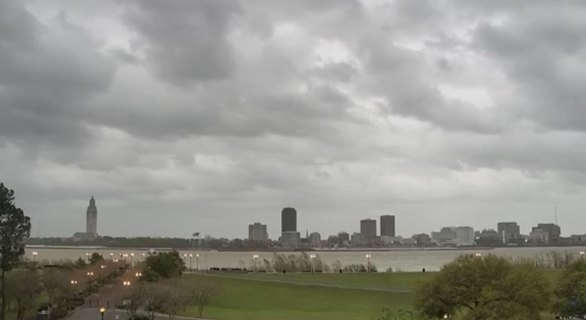
OLOL tower on Essen
False River in New Roads
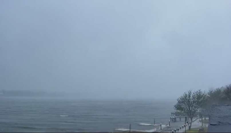
LINK - WAFB
False river will be the first one to get really hairy. Already starting to get choppy. Livingston probably the last one.
Baton Rouge
OLOL tower on Essen
False River in New Roads
LINK - WAFB
This post was edited on 3/30/22 at 4:47 pm
Posted on 3/30/22 at 4:39 pm to The Boat


Posted on 3/30/22 at 4:40 pm to Tear It Up
quote:I will go to my grave thinking the Indian Mounds at LSU ward off the worst weather from southwest Baton Rouge. The effect fades out the further you get from them which is why Denham Springs has gotten popped while I’ve been fine in the past. The Indian Mounds are also the reason Ida’s track shifted east.
I’m 7th grade TN History class they told us it was the bluffs that kept tornadoes from hitting the Bluff City.
Posted on 3/30/22 at 4:41 pm to The Boat
OBSERVED TORNADO HEADED TO JACKSON, MISS.

This post was edited on 3/30/22 at 4:42 pm
Posted on 3/30/22 at 4:41 pm to red sox fan 13
Something big is getting tossed around a neighbor’s yard. I was sitting outside and the bang scared the shite out of me 
Posted on 3/30/22 at 4:42 pm to Wishnitwas1998
quote:
Duke, I hear this shite all the time and it makes me so irrationally angry but i shouldn’t let it bc the ppl who are convinced of it WILL NOT budge an inch on it
My teacher was the head HS football coach, so his meteorological expertise was questionable. If you did question it, I’m sure you would get paddled by him.
Posted on 3/30/22 at 4:43 pm to red sox fan 13
possible Jackson, Miss. tornado may be on Ryan Hall Y'all YouTube LIVE shortly

 Page 50 of 92

Popular
Back to top