- My Forums
- Tiger Rant
- LSU Recruiting
- SEC Rant
- Saints Talk
- Pelicans Talk
- More Sports Board
- Fantasy Sports
- Golf Board
- Soccer Board
- O-T Lounge
- Tech Board
- Home/Garden Board
- Outdoor Board
- Health/Fitness Board
- Movie/TV Board
- Book Board
- Music Board
- Political Talk
- Money Talk
- Fark Board
- Gaming Board
- Travel Board
- Food/Drink Board
- Ticket Exchange
- TD Help Board
Customize My Forums- View All Forums
- Show Left Links
- Topic Sort Options
- Trending Topics
- Recent Topics
- Active Topics
Started By
Message
re: Laura - President Trump visits Lake Charles, Louisiana for Hurricane Response Update
Posted on 8/22/20 at 8:16 am to DeepBlueSea

Posted on 8/22/20 at 8:16 am to DeepBlueSea
Quick someone go throw some YETIs in the gulf
 0
0


Posted on 8/22/20 at 8:16 am to UnitedFruitCompany
TS Laura nearing Puerto Rico this morning:


Posted on 8/22/20 at 8:19 am to Bobby OG Johnson
I have joked that some tiger fan made a deal with some voodoo queen for the 2019 season and we got 2020 as a result, if this happens it’s all but a fact

Posted on 8/22/20 at 8:20 am to Roll Tide Ravens
That radar is misleading. The low level circulation is actually on the NE tip of Puerto Rico. What looks like the heart of the storm with all the convection is the mid level circulation.
Posted on 8/22/20 at 8:20 am to Dire Wolf
Mother of God
Posted on 8/22/20 at 8:21 am to lsuman25
So your saying it Marco went from 35-40mph to 50 to 65 mph winds that quick?

Posted on 8/22/20 at 8:22 am to jimbeam
Hello Marco!

Ready to be a hurricane?
Ready to be a hurricane?
Posted on 8/22/20 at 8:23 am to lsufan4lifeMiles
Looks like it, small circulations like this can intensify rapidly. Could weaken rapidly also if conditions aren't good.
Posted on 8/22/20 at 8:24 am to rmnldr
Marco looks intense!! If it becomes a Hurricane a Louisiana Landfall is probably intimate.

Posted on 8/22/20 at 8:24 am to Dire Wolf
Looks like the offshore fishing trip I’m supposed to go on Friday may be a washout. I would imagine the under swells will wreak havoc on fishing....
Posted on 8/22/20 at 8:26 am to BuddyRoeaux
Levi seems to be hinting pretty strongly that he disagrees with the models and thinks this will end up further east into Louisiana. In my opinion, he is one of the best out there. It’s crazy having to closely watch two at the same time.
Posted on 8/22/20 at 8:28 am to BigB0882
quote:
Levi seems to be hinting pretty strongly that he disagrees with the models and thinks this will end up further east into Louisiana. In my opinion, he is one of the best out there. It’s crazy having to closely watch two at the same time.
Talking about Marco?
Posted on 8/22/20 at 8:28 am to BuddyRoeaux
space city weathers morning update
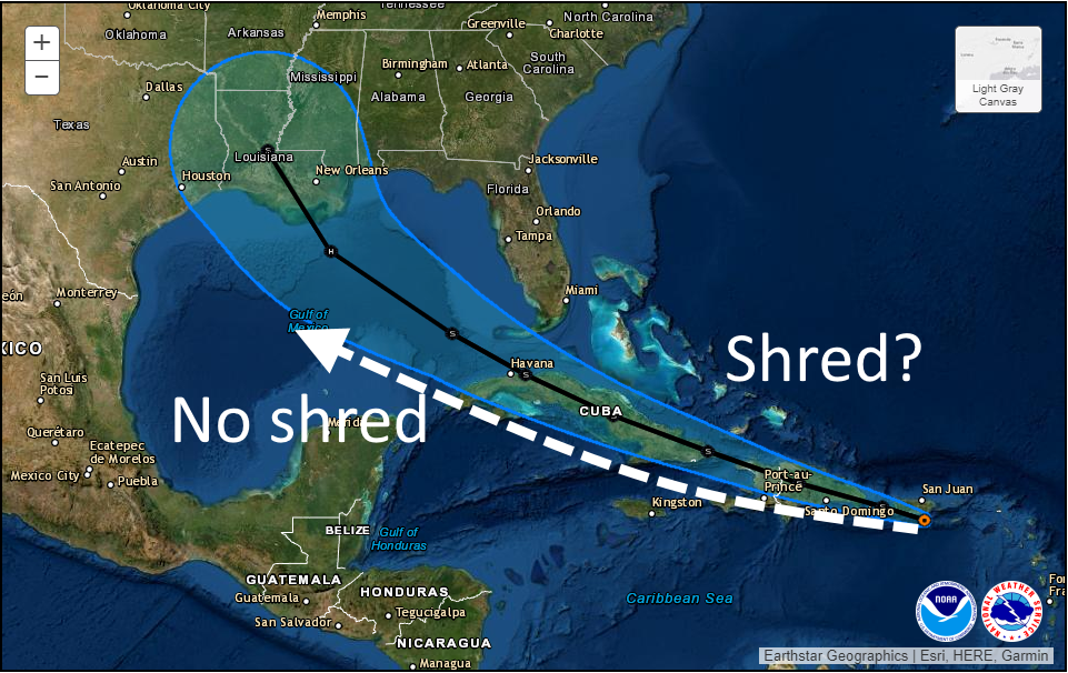
[img]Along the current National Hurricane Center track (shown in black) Laura will traverse the mountainous terrain of Hispaniola, followed by the spine of Cuba. If the system is already a struggling tropical storm, it is difficult to see how a particularly organized system emerges into the Gulf of Mexico. Therefore the threat of Laura becoming a hurricane next week diminishes. However, if the storm can find a track just south of the islands, then it has a chance to escape the shredder and move into the Gulf later on Monday poised to intensify.
In terms of track, anything is still possible. Under the “no-shred” track above, Texas would probably be threatened by a hurricane next Wednesday or Thursday. Under the shred track, a weaker system probably comes toward Louisiana. But our confidence in a track remains very low.[/img]
LINK
quote:
Tropical Storm Marco
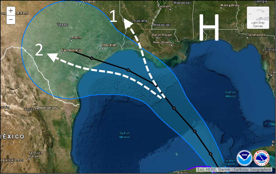
It appears that Marco has begun to intensify further overnight, and the storm has 50 mph sustained winds. If Marco continues to strengthen further this weekend, up to hurricane strength, it likely will take a more northerly track, toward southeastern Louisiana. However a weaker storm is more likely to move more westward, toward the central or upper Texas coast. Why? Because a stronger storm might have more impetus to barrel into building high pressure over the southeastern United States, whereas a weaker one would be more steerable to the west. Here’s a map showing the National Hurricane Center forecast track (in black) along with a couple of scenarios:
quote:
Scenario One, in which Marco never really makes a leftward turn while over the Gulf, would lead to limited impacts for the Houston metro area and the potential for heavy rainfall in southern Louisiana. Scenario Two will bring a decent amount of rainfall to the Houston region—2 to 6 inches, maybe?—along with elevated tides. At this point I would weight these two scenarios equally, in terms of probability.
Because there is so much uncertainty in the track and intensity, projecting other effects such as a storm surge is sort of fruitless. However, probably a worst case scenario is seas about six feet higher than normal along Galveston by late Monday. Peak winds, of tropical storm strength, would likely arrive here by late Monday. All of this is subject to change. All of this.
quote:
Tropical Storm Laura
Oh, we have many questions about Laura as well. At present the system is fairly disorganized, and contending with its “center” moving over Puerto Rico. What happens over the next 24 to 48 hours will probably have important implications how how menacing Laura ultimately becomes when it moves into the Gulf of Mexico. Here’s what I mean by that:
[img]Along the current National Hurricane Center track (shown in black) Laura will traverse the mountainous terrain of Hispaniola, followed by the spine of Cuba. If the system is already a struggling tropical storm, it is difficult to see how a particularly organized system emerges into the Gulf of Mexico. Therefore the threat of Laura becoming a hurricane next week diminishes. However, if the storm can find a track just south of the islands, then it has a chance to escape the shredder and move into the Gulf later on Monday poised to intensify.
In terms of track, anything is still possible. Under the “no-shred” track above, Texas would probably be threatened by a hurricane next Wednesday or Thursday. Under the shred track, a weaker system probably comes toward Louisiana. But our confidence in a track remains very low.[/img]
LINK
Posted on 8/22/20 at 8:28 am to BigB0882
Marco gonna hit SELa and Laura gonna smack SWLA? Cool.
Posted on 8/22/20 at 8:29 am to BigB0882
Levi Cowan
@TropicalTidbits
·
3m
#Marco is forming an eyewall on Cuba radar as it approaches the Yucatan Channel while rapidly intensifying.
Cuban Radar showing eyewall trying to form
@TropicalTidbits
·
3m
#Marco is forming an eyewall on Cuba radar as it approaches the Yucatan Channel while rapidly intensifying.
Cuban Radar showing eyewall trying to form
This post was edited on 8/22/20 at 8:31 am
Posted on 8/22/20 at 8:29 am to lsuman25
90+ degree water and a defined eye-wall sounds like disaster for us weather geeks. I’m rerunning the models now. It’s getting closer to the east side of Houston. We do not want a Louisiana Landfall. Especially If Laura intensified after beating up Puerto Rico and Cuba. If it’s a Cat 2 or weak Cat 3. It’s a smaller Katrina like storm. New Orleans does not need that at all.
This post was edited on 8/22/20 at 8:32 am
Posted on 8/22/20 at 8:29 am to lsufan4lifeMiles
quote:
Marco looks intense!! If it becomes a Hurricane a Louisiana Landfall is probably intimate.


Posted on 8/22/20 at 8:36 am to lsufan4lifeMiles
quote:
a Louisiana Landfall is probably intimate.
Posted on 8/22/20 at 8:37 am to lsuman25
Marco reforming or moving almost due north in the short term. Will be interesting to see if this continues or not.

Posted on 8/22/20 at 8:38 am to notiger1997
Both of these storms are going to Texas

 Page 79 of 815

Popular
Back to top