




- My Forums
- Tiger Rant
- LSU Recruiting
- SEC Rant
- Saints Talk
- Pelicans Talk
- More Sports Board
- Fantasy Sports
- Golf Board
- Soccer Board
- O-T Lounge
- Tech Board
- Home/Garden Board
- Outdoor Board
- Health/Fitness Board
- Movie/TV Board
- Book Board
- Music Board
- Political Talk
- Money Talk
- Fark Board
- Gaming Board
- Travel Board
- Food/Drink Board
- Ticket Exchange
- TD Help Board
Customize My Forums- View All Forums
- Show Left Links
- Topic Sort Options
- Trending Topics
- Recent Topics
- Active Topics
Started By
Message
re: Laura - President Trump visits Lake Charles, Louisiana for Hurricane Response Update
Posted on 8/25/20 at 10:36 pm to Hulkklogan


Posted on 8/25/20 at 10:36 pm to Hulkklogan
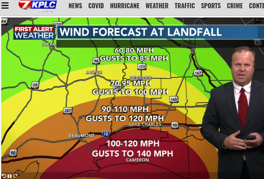
Sustained
Gusts
Gusts
 3
3

Posted on 8/25/20 at 10:36 pm to slackster
988 mb & 76 kt (87.5 mph) winds at the surface in the east eyewall per dropsonde
Posted on 8/25/20 at 10:36 pm to Duke
quote:
What's so funny is the eye is going to be bigger than these 10 mile shifts. Might matter for the Triangle but doesn't really change the game east of the Sabine.
It will contract as the storm strengthens and that also probably keeps EWRC off the table but the triggers for EWRC aren't very well understood. Anyway, the east "shift" for Advisory 24 vs 25.


Posted on 8/25/20 at 10:37 pm to LaBR4
He just said, "this will be worse than rita"

Posted on 8/25/20 at 10:38 pm to Wishnitwas1998
quote:
Was caught up to the thread late last night
Then it goes over a 100 pages today
You're welcome.
Most of it is relevant, useful, and timely information. I wouldn't recommend skipping any. It builds on itself.
Posted on 8/25/20 at 10:38 pm to SW2SCLA
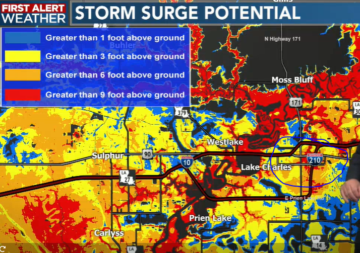
What's the deal with how much real water could end up in the 210 area? Prien Lake mall? Nelson road/casino areas?
This post was edited on 8/25/20 at 10:39 pm


Posted on 8/25/20 at 10:38 pm to rds dc
Is that really much of a shift or just straight lines between data points fooling us?

Posted on 8/25/20 at 10:38 pm to Impotent Waffle
quote:
I think the point is the more east it comes the more widespread the impact in La becomes
It's going to take a bigger shift east to really change the Louisiana impacts.

Posted on 8/25/20 at 10:38 pm to Duke
quote:
It's all warm and deep

Posted on 8/25/20 at 10:39 pm to Cosmo
quote:
just straight lines between data points fooling us?
I'd say this since the points are still on the same line.


Posted on 8/25/20 at 10:39 pm to LaBR4
Man, south of LC is going to be brutal
Posted on 8/25/20 at 10:39 pm to SW2SCLA
That's a pretty ignorant thing to say especially when you consider the lack of resources Rita was able to get to people due to Katrina.
Posted on 8/25/20 at 10:41 pm to SW2SCLA
(no message)
This post was edited on 12/17/21 at 11:59 pm


Posted on 8/25/20 at 10:41 pm to LaBR4
From Crown Weather Services (subscription service) - email forwarded to me
quote:
2020 Tuesday Evening Update On Hurricane Laura Hurricane Laura: 8 pm EDT/7 pm CDT Statistics: Location: 25.0 North Latitude, 89.0 West Longitude or about 465 miles to the southeast of Galveston, Texas. Maximum Winds: 85 mph. Minimum Central Pressure: 983 Millibars or 29.03 Inches. Forward Movement: West-Northwest at a forward speed of 17 mph.
As expected, Laura is strengthening quickly this evening and reconnaissance aircraft are now finding a slightly stronger storm with each new pass through the hurricane. At this point, I think that Laura is probably at or very near Category 2 strength with 100 mph winds based on what reconnaissance aircraft are finding and how quick the storm is wrapping up on satellite imagery. Finally, latest barometric pressure readings from reconnaissance aircraft have found a pressure of 982 millibars and falling quickly.
As for the forecast track update – Many of the model guidance members have shifted eastward today with their forecast track of Laura. So, my question is this just another daytime shift eastward by the guidance where they will shift back to the west again with tonight’s model runs? Analysis of model guidance errors so far finds that the UKMET model seems to be still doing the best with its forecast track of Laura and it is forecasting Laura to make landfall about halfway between Galveston and Port Arthur late tomorrow night.
Based on this, I’m shifting my forecast track landfall point slightly to the east, but I am still just west of the forecast from the National Hurricane Center. This is an extraordinarily tough forecast because the difference of just 40 miles to the west would bring a major hurricane right into Galveston. On the other hand, if Laura ends up tracking just 40 miles to the east of my forecast track, it would put Port Arthur and Beaumont on the much weaker side of the hurricane, but would cause major damage to Cameron Parish and Vermilion Parish.
There are no changes to my forecast intensity forecast – I think we are now starting to see the first indications of rapid strengthening based on satellite imagery and reconnaissance aircraft reports. This means that I think that Laura is probably very near Category 2 strength now and probably will reach Category 3 intensity by midday Wednesday and finally Category 4 strength by Wednesday evening.
I also still think that Laura will make landfall as about a Category 4 hurricane with winds somewhere between 130 mph and 150 mph in an area about halfway between Galveston Island and Sabine Pass near sunrise Thursday morning. With that said, I am still concerned about a shallower turn or wobbles of the eye and eyewall as Laura approaches the Texas coast late tomorrow.
This means that I think the area from Freeport, Texas to Cameron, Louisiana is still at very significant risk from a major hurricane. I also worry that I’ve shifted my forecast track too far east and have concerns that the eastern end of Galveston Island will be where Laura makes landfall. Little wobbles in the storm’s track over the next 24 to 30 hours is going to mean a lot.
This post was edited on 8/25/20 at 10:44 pm
Posted on 8/25/20 at 10:41 pm to deuce985
Lack of resources due to corona?

Posted on 8/25/20 at 10:42 pm to Duke
quote:
It's all warm and deep
Sounds kinda dirty...
Posted on 8/25/20 at 10:42 pm to rt3
GFS appears to be right on the NHC track on this run.

Posted on 8/25/20 at 10:42 pm to deuce985
Though I will say it will be interesting to see the impacts afterwards as far as recovery goes and how Covid-19 will slow it down. There isn't really another natural disaster to take eyes off this storm though so all the resources will be focused in the impacted areas.
Posted on 8/25/20 at 10:43 pm to deuce985
In a serious note, my folks are staying in Opelousas and VP, and I haven't been able to convince them otherwise. If this track holds up or of it shifts any more east it's not gonna be pretty in that area either.
Guess we all have to make our decisions.
Guess we all have to make our decisions.
This post was edited on 8/25/20 at 10:43 pm
Posted on 8/25/20 at 10:43 pm to rds dc
quote:
It will contract as the storm strengthens
Sure but it should still be fairly large by the coastal approach.
quote:
that also probably keeps EWRC off the table but the triggers for EWRC aren't very well understood.
Agreed that EWRCs don't look likely. Though if the eye can contract enough, the changing shear conditions might be a trigger (realizing that I'm just spitballing).

 Page 402 of 815

Popular
Back to top
 Follow TigerDroppings for LSU Football News