- My Forums
- Tiger Rant
- LSU Recruiting
- SEC Rant
- Saints Talk
- Pelicans Talk
- More Sports Board
- Fantasy Sports
- Golf Board
- Soccer Board
- O-T Lounge
- Tech Board
- Home/Garden Board
- Outdoor Board
- Health/Fitness Board
- Movie/TV Board
- Book Board
- Music Board
- Political Talk
- Money Talk
- Fark Board
- Gaming Board
- Travel Board
- Food/Drink Board
- Ticket Exchange
- TD Help Board
Customize My Forums- View All Forums
- Show Left Links
- Topic Sort Options
- Trending Topics
- Recent Topics
- Active Topics
Started By
Message
re: Laura - President Trump visits Lake Charles, Louisiana for Hurricane Response Update
Posted on 8/22/20 at 9:43 pm to slackster
Posted on 8/22/20 at 9:43 pm to slackster
quote:
Recon hasn’t been in the center of the storm in a few hours now, but regardless, that’s my point. I want to see if they address the infrared they’ve had come in since recon left.
Recon was just in there in the last hour or so.
Strongest winds are north of DR at flight level. Didn't have a center fix. Did find some weak and cyclonic turning winds to the south that is probably a little vort center rotating around the main center that is over land. The convection is impressive but it's displaced as there is some northerly mid-level shear pushing at Laura.
 2
2


Posted on 8/22/20 at 9:44 pm to Bobby OG Johnson
Man, those planes are going fast. Must be SR71’s

Posted on 8/22/20 at 9:44 pm to rt3
Youngsville’s collective butthole clinches
Posted on 8/22/20 at 9:45 pm to jimbeam
quote:
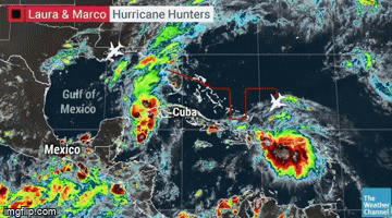
...MARCO MOVING NORTH-NORTHWESTWARD ACROSS THE SOUTHERN GULF OF MEXICO... ...STORM SURGE AND HURRICANE WATCHES IN EFFECT FOR PORTIONS OF THE NORTHERN GULF COAST...
10:00 PM CDT Sat Aug 22
Location: 22.8°N 86.3°W
Moving: NNW at 13 mph
Min pressure: 994 mb
Max sustained: 65 mph

Posted on 8/22/20 at 9:45 pm to Armymann50
TWC MILF
"Well, there will be a little break in the most intense rain, at least you have that going for you."
"Well, there will be a little break in the most intense rain, at least you have that going for you."
Posted on 8/22/20 at 9:46 pm to LaBR4
Downward pointing nipple. WNHI

Posted on 8/22/20 at 9:46 pm to geauxtigers87
quote:
JBE
Has that toad declared a SOE yet?
I saw Tator Tot’s earlier but haven’t seen JBE.
Posted on 8/22/20 at 9:47 pm to LaBR4


Posted on 8/22/20 at 9:47 pm to TigerNAtux
Pretty sure he did

Posted on 8/22/20 at 9:47 pm to CharlesLSU
quote:
CharlesLSU
I've missed you, friend.
Posted on 8/22/20 at 9:48 pm to Tyga Woods
quote:
Man, those planes are going fast. Must be SR71’s
Give me some of whatever the dude starting around Marco is on.
Posted on 8/22/20 at 9:49 pm to AmosMosesAndTwins
the western tip of Cuba is under a tropical storm warning for Marco & a tropical storm watch for Laura

Posted on 8/22/20 at 9:50 pm to Duke
Did Avila retire? He was my fav NHC baw
Posted on 8/22/20 at 9:51 pm to rt3

Posted on 8/22/20 at 9:51 pm to lsuman25
This looks like a slower track... does that mean more sheer over the islands or more time to intensify... or both?
Posted on 8/22/20 at 9:52 pm to Cosmo
quote:
Did Avila retire? He was my fav NHC baw
He retired this year I think.
Shift to being an Eric Blake stan.

Posted on 8/22/20 at 9:52 pm to rt3
New advisory calls for wind gusts to up to 115mph with Laura at landfall. 90mph sustained winds at landfall.
Posted on 8/22/20 at 9:52 pm to slackster
quote:
Slackster
After seeing so many posts, I feel I have to respond... It’s very clear you’ve taken this as your own personal battle tonight , and that’s cool
I’m not sure exactly where this started earlier in the thread....
The Northeast quadrant of tropical storms and hurricanes are typically the first to come together and hold together and typically always strongest here in the northern Atlantic. It is what it is. It’s physics and thermodynamics, and it typically holds serve.
Yes, based on graphic you provided, if a perfectly formed and perfectly symmetric hurricane hit at the right direction and angle, then another quadrant may produce a more net positive and stronger set of winds based on the hurricane’s forward direction and speed at the time.
But systems aren’t usually perfect. And east side of hurricane here is overwhelmingly the ‘worst’ side. And subsequently the NE is overwhelmingly the strongest and most solid quadrant.
Posted on 8/22/20 at 9:52 pm to rt3
I just realized how slow Marco's supposed to be after making landfall
24 hours after landfall in southeast/south central Louisiana... it;s just getting to the LA/TX border
24 hours after landfall in southeast/south central Louisiana... it;s just getting to the LA/TX border
Posted on 8/22/20 at 9:52 pm to rt3
11pm has Marco trending south and Laura trending East.

 Page 122 of 815

Popular
Back to top