- My Forums
- Tiger Rant
- LSU Recruiting
- SEC Rant
- Saints Talk
- Pelicans Talk
- More Sports Board
- Fantasy Sports
- Golf Board
- Soccer Board
- O-T Lounge
- Tech Board
- Home/Garden Board
- Outdoor Board
- Health/Fitness Board
- Movie/TV Board
- Book Board
- Music Board
- Political Talk
- Money Talk
- Fark Board
- Gaming Board
- Travel Board
- Food/Drink Board
- Ticket Exchange
- TD Help Board
Customize My Forums- View All Forums
- Show Left Links
- Topic Sort Options
- Trending Topics
- Recent Topics
- Active Topics
Started By
Message
re: Ian Observation Thread (Storm Track and Radar inside)
Posted on 9/22/22 at 9:12 pm to Ice Cream Sammich
Posted on 9/22/22 at 9:12 pm to Ice Cream Sammich
quote:
What are the chances it continues to shift so far east that it does a 320* spin and comes back to Louisiana?
Ill hangup and listen.
The Icon was actually doing that a couple runs ago.
 0
0

Posted on 9/22/22 at 9:13 pm to Dire Wolf
quote:
ive always wondered what the remints of a fish storm hurricane look like that far north.
Sort of like how moisture from tycoons ride the jet stream back to the pac NW. What downstream weather comes from fish storms that no one talks about?
you'd think some of the legendary storms of Scotland, Ireland, & England might have been Atlantic "fish storms" that had become extra-tropical
Posted on 9/22/22 at 9:16 pm to Dire Wolf
quote:
ive always wondered what the remints of a fish storm hurricane look like that far north.
They end up looking like those comma winter storms, because they are undergoing the same processes at that point.
Fiona is going to be interesting to watch because it is going to be an explosive version of the process.
Posted on 9/22/22 at 9:19 pm to Ice Cream Sammich
quote:
What are the chances it continues to shift so far east that it does a 320* spin and comes back to Louisiana?
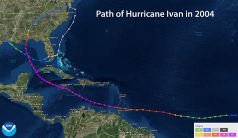
We call that doing the Ivan.
This post was edited on 9/22/22 at 9:25 pm

Posted on 9/22/22 at 9:19 pm to deltaland
quote:
Told y’all I willed it with my mind
Nah dude. I’m going on a hunting trip with a bunch of Texas fans next week. Knowing how gay they are, I asked them all to get on their knees and blow really hard towards Florida. They agreed and it worked. Such queers those guys.
Posted on 9/22/22 at 9:26 pm to LegendInMyMind
quote:
Gonna be some damn good satellite watching in the next few days.
That and some buoy data watching. Fiona generating 34 foot significant wave heights almost 100 miles away from center. Might be almost some 'mini' Perfect Storm-like waves up south of Nova Scotia.
Posted on 9/22/22 at 9:27 pm to LegendInMyMind
Ive lived in BR for 34 years. I never knew that.
Posted on 9/22/22 at 9:28 pm to NorthEndZone
The trend is our friend!

Posted on 9/22/22 at 9:30 pm to LSUTiger23
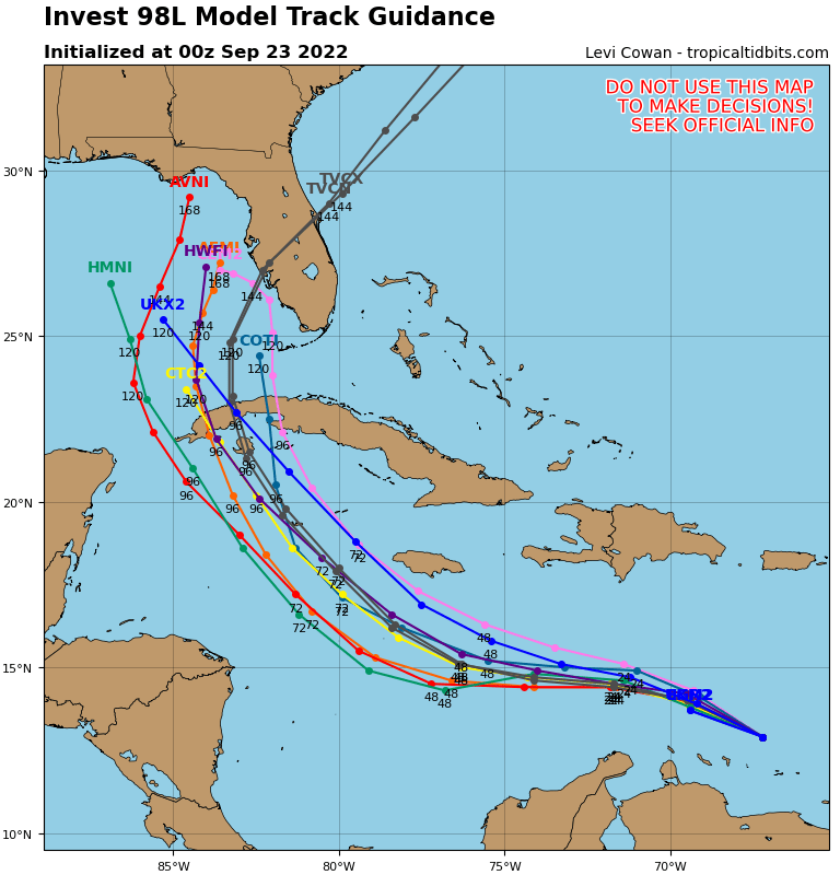
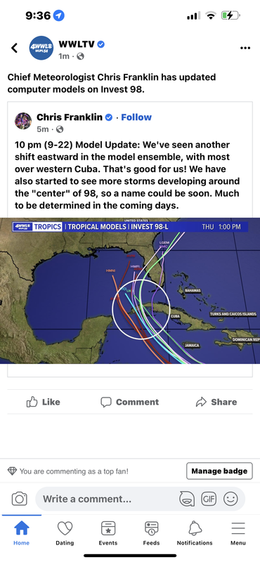
Even HMON now caving in

Posted on 9/22/22 at 9:32 pm to LSUTiger23
Damn, the TVCN (NHC) has it over Port Charlotte now, north of Fort Meyers. Crazy.
This post was edited on 9/22/22 at 9:33 pm
Posted on 9/22/22 at 9:32 pm to NorthEndZone
quote:
That and some buoy data watching. Fiona generating 34 foot significant wave heights almost 100 miles away from center. Might be almost some 'mini' Perfect Storm-like waves up south of Nova Scotia.
Have you seen the video from the "ocean drone" yet?
This post was edited on 9/22/22 at 9:35 pm
Posted on 9/22/22 at 9:35 pm to LSUTiger23

There's that area of yellow near the tip of Cuba. That's the upper low that is responsible for the Euro being so far east. It is both weak, which means it can't nudge it out of the way and closer to it, which means it gets tugged north more.
The Euro is probably too weak with the system, and thus too far to the east overall.
This isn't shift it back to the Panhandle big for the Euro. If I'm right and the storm is a bit stronger than it sees, it is more like a shift to the middle of the peninsula vs the far southern extreme/missing it entirely. Based on everything else the European is doing.
Posted on 9/22/22 at 9:38 pm to Ice Cream Sammich
quote:
Ive lived in BR for 34 years. I never knew that.
Ivan was a fricking warrior who had no quit in it.
I always like to drop this bit of info whenever Ivan comes up:
quote:
When Ivan entered the Gulf of Mexico, U.S. Naval Research Laboratory ocean-floor pressure sensors detected a freak wave, which was caused by the hurricane. The wave was around 91 feet (28 m) high from peak to trough, and around 660 feet (200 m) long.[4] Their computer models also indicated that waves may have exceeded 130 feet (40 m) in the eyewall.[5]
This post was edited on 9/22/22 at 9:39 pm

Posted on 9/22/22 at 9:42 pm to LegendInMyMind
quote:no the frick we dont
We call that doing the Ivan.
Posted on 9/22/22 at 9:46 pm to JS87

Hell of a convective burst continuing downshear (SW side) tonight. rds alluded to the center trying to reform downshear under the deep convection earlier tonight. Could see that happening if it stays that vigorous.
The GFS has been seeing this process happening (overdoing it most likely) and is part of why it has been so far south. Now we watch to see what extent that downshear convection has on it's location.
Posted on 9/22/22 at 9:47 pm to Duke
Whoops drunk double post
This post was edited on 9/22/22 at 9:48 pm
Posted on 9/22/22 at 9:47 pm to Duke
quote:
The GFS has been seeing this process happening (overdoing it most likely) and is part of why it has been so far south. Now we watch to see what extent that downshear convection has on it's location.
So if it's further south, that's bad correct?
For us in God's country atleast

Posted on 9/22/22 at 9:48 pm to LegendInMyMind
A 30 ft wave seems just unreal. But a 91 ft wave is insane.
Posted on 9/22/22 at 9:52 pm to LegendInMyMind
quote:
Have you seen the video from the "ocean drone" yet?
thanks for link. Nice.
Sometimes I think I'd like to be on a large oceangoing vessel in waves that large just to see the power of nature firsthand.
There was a ship reporting from just SE of Fiona earlier today. It seemed to not be avoiding the storm as it reported high winds and seas for several hours.
47.6 foot significant waves was the highest it reported and 65 knot winds a little over 100 miles from the center.

 Page 97 of 465

Popular
Back to top