- My Forums
- Tiger Rant
- LSU Recruiting
- SEC Rant
- Saints Talk
- Pelicans Talk
- More Sports Board
- Fantasy Sports
- Golf Board
- Soccer Board
- O-T Lounge
- Tech Board
- Home/Garden Board
- Outdoor Board
- Health/Fitness Board
- Movie/TV Board
- Book Board
- Music Board
- Political Talk
- Money Talk
- Fark Board
- Gaming Board
- Travel Board
- Food/Drink Board
- Ticket Exchange
- TD Help Board
Customize My Forums- View All Forums
- Show Left Links
- Topic Sort Options
- Trending Topics
- Recent Topics
- Active Topics
Started By
Message
re: Ian Observation Thread (Storm Track and Radar inside)
Posted on 9/22/22 at 12:07 am to BregmansWheelbarrow
Posted on 9/22/22 at 12:07 am to BregmansWheelbarrow
The ensembles have been lagging behind the operational run by a couple runs. A reminder that they are run at a lower resolution than the operational ad well.
 3
3

Posted on 9/22/22 at 12:12 am to Oates Mustache
The other models have done that but not the GFS for some reason.

Posted on 9/22/22 at 12:12 am to lsugolfredman
quote:

quote:


This post was edited on 9/22/22 at 12:13 am
Posted on 9/22/22 at 12:15 am to lsugolfredman
This illustrates the process Duke was talking about and the frames I posted earlier and is what could be the why that makes the GFS do what it does.
You see the Northern jog where it feels the pull North. Then, it immediately goes back South and continues a more Westward track. What could be causing that is convection downstream of the system that overpowers the pull North and forces the center to form more to the SW. The Euro doesn't show this at all, and it is where the two models diverge from each other.
ETA: And as Duke mentioned it is one of the known biases of the GFS.
This post was edited on 9/22/22 at 12:20 am
Posted on 9/22/22 at 12:22 am to LegendInMyMind
Shouldn't we be regarding these runs rather lightly since there isn’t even a formed storm and center to model?
Posted on 9/22/22 at 12:25 am to lsugolfredman
Reading these threads when the big guys talk really makes me feel like a fricking retard 
I have no clue what y’all are saying I just try to take the overall tone of your posts
I have no clue what y’all are saying I just try to take the overall tone of your posts
Posted on 9/22/22 at 12:25 am to rds dc
I make my decisions off of Jay Grymes' sleeves
Suit jacket on today so i'm comfortable
Suit jacket on today so i'm comfortable
Posted on 9/22/22 at 12:38 am to LegendInMyMind
I actually understood that that’s a pretty good explanation.
And to be perfectly honest, the still frames weren’t doing it for me. The gif is what put me over the top.
And to be perfectly honest, the still frames weren’t doing it for me. The gif is what put me over the top.
This post was edited on 9/22/22 at 12:40 am
Posted on 9/22/22 at 12:39 am to Jake88
quote:
Shouldn't we be regarding these runs rather lightly since there isn’t even a formed storm and center to model?
I'll put it to you this way, I'm barely paying attention to what the models are doing once it hits the Gulf. They're of dubious value past a couple of days. What matters the most is where it actually forms.
We're still firmly in ensemble mode for potential Gulf Coast landfall.

Posted on 9/22/22 at 12:49 am to Duke
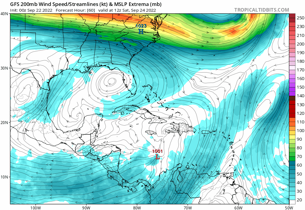
You watching the GFS ensembles? Lots of members in the central gulf of Mexico at 180hr.
Posted on 9/22/22 at 1:38 am to Oates Mustache
If you're wanting to cheerlead for a model, the Euro is the one. Not good at all for Florida though, it would wreck shite.

Posted on 9/22/22 at 2:06 am to Oates Mustache

The Euro has two differences. It isn't building through quick bursts like the GFS is. It remains weaker longer. It doesn't feel the push to the south as much due to the weaker nature of the system.
The GFS is getting that taller system pushed further south and doing some pinwheeling with it's vorts as it consolidates into a bonafide tropical system.

The end result is a much different launching point when it feels the turn north. Those differences compound into seeing the Euro have it fully captured and pulled NE and the GFS misses the NE push and gets it stuck moving due north instead.

Posted on 9/22/22 at 2:09 am to Oates Mustache
Printing the shirts for team Euro, sorry Florida.
This post was edited on 9/22/22 at 5:57 am

Posted on 9/22/22 at 5:21 am to LegendInMyMind
quote:...
It isn't as obvious on still frames

Posted on 9/22/22 at 5:49 am to JCinBAMA
New GFS gonna make LC people have a stroke!

Posted on 9/22/22 at 5:54 am to Run up middle
Just where I want to be this far out!
Posted on 9/22/22 at 5:56 am to BallsEleven
I believe this is the 3rd or 4th time the GFS has had LC hit with a major this year.
Posted on 9/22/22 at 6:03 am to Run up middle
Gfs has swung it from Florida to LC in a day. Euro says frick you Florida
I'm on team whatever isn't southeast la
I'm on team whatever isn't southeast la

Posted on 9/22/22 at 6:05 am to maisweh
Dry air from Santa will save LA. Get ready Florida Man.
Posted on 9/22/22 at 6:06 am to maisweh
GFS can eat a bag of dicks

 Page 64 of 465

Back to top