- My Forums
- Tiger Rant
- LSU Recruiting
- SEC Rant
- Saints Talk
- Pelicans Talk
- More Sports Board
- Fantasy Sports
- Golf Board
- Soccer Board
- O-T Lounge
- Tech Board
- Home/Garden Board
- Outdoor Board
- Health/Fitness Board
- Movie/TV Board
- Book Board
- Music Board
- Political Talk
- Money Talk
- Fark Board
- Gaming Board
- Travel Board
- Food/Drink Board
- Ticket Exchange
- TD Help Board
Customize My Forums- View All Forums
- Show Left Links
- Topic Sort Options
- Trending Topics
- Recent Topics
- Active Topics
Started By
Message
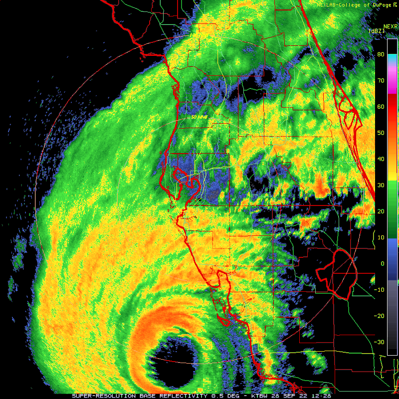
re: Ian Observation Thread (Storm Track and Radar inside)
Posted on 9/28/22 at 8:14 am to deltaland

Posted on 9/28/22 at 8:14 am to deltaland
Is this storm lopsided? NW quadrant looks to be more badass than the normally stronger NE quadrant. It’s odd the storm is maybe 40 miles offshore yet the winds on the coast where the talking heads are seem mild.
 1
1

Posted on 9/28/22 at 8:14 am to The Boat
quote:
The eye is clearing out by the second. I would be surprised if they don't upgrade this to 160 mph.
Recon has spent the last half hour in the eye. We'll see what they do at 9am update I guess.
7am and 8am have stayed at 937mb and 155 mph.
Posted on 9/28/22 at 8:15 am to OU Guy
quote:
“Since 1965 this will be the 6th major hurricane to hit the Florida peninsula south of a Cape Canaveral to Tampa line. The 50 years previous to 1965, there were *16*”
Nice. Prepare to have the goalposts moved.
A steady 3 mph with 30ish gusts aboot every 10 minutes here.

Posted on 9/28/22 at 8:15 am to stout
I don't disagree with any of that, but it's more about having more major hurricanes, not just more storms overall. granted, this is also part on our prediction methods, but major hurricanes have exceeded probability for decades.
LINK

LINK
quote:
The main focus of this work is the identification of global changes in TC intensity (Figs. 1 and 2). When the global data are parsed into regional subsets, there is an expectation for changes in signal-to-noise ratios and greater sensitivity to known regional modes of variability (e.g., the Interdecadal Pacific Oscillation [IPO], Atlantic Multidecadal Oscillation [AMO], or Indian Ocean Dipole [IOD]). Nonetheless, it is generally informative to identify changes and trends within individual ocean basins, and results of the regional analyses are shown in Table 1 and Fig. 3. The greatest changes are found in the North Atlantic, where the probability of major hurricane exceedance increases by 49% per decade, significant at greater than the 99% confidence level (Table 1). Consistent with this, an increasing trend is found in the triad time series of the proportion of major hurricane intensities (Fig. 3) that represents an increase of 42% per decade, significant with 98% confidence (Table 1).
This post was edited on 9/28/22 at 8:19 am

Posted on 9/28/22 at 8:15 am to Mizzoufan26

Posted on 9/28/22 at 8:16 am to BOSCEAUX
quote:
It’s odd the storm is maybe 40 miles offshore yet the winds on the coast where the talking heads are seem mild.
That's how hurricanes are structured. People have been conditioned to think hurricane force winds extend the entire duration of the structure. In reality they're in a narrow area around the core.
Posted on 9/28/22 at 8:16 am to liz18lsu
quote:
They are fine
quote:
When you evacuate FL WTF are you gonna go?
Probably not here

Posted on 9/28/22 at 8:16 am to Zapps4Life
quote:
If someone can render/post animated loop = thanks
Posted on 9/28/22 at 8:16 am to jmcwhrter
quote:
Take all the ones that people abandoned on I4 when they died during evacuation, and chuck em into the gulf as a debris field
No way, those batteries are terrible for the environment.
Don’t need them messing up my seafood for the next decade.

Posted on 9/28/22 at 8:17 am to slackster
Lightning in the eye wall.
Posted on 9/28/22 at 8:17 am to TigerDude80

Posted on 9/28/22 at 8:17 am to LegendInMyMind
quote:
My condolences if you're watching him. I just can't. He makes me want to kick puppies.
Dude is a clown, he didn’t even have enough sense to check all sides of the garage…and is his partner in the Jeep also named Jeff? Annoying AF
Posted on 9/28/22 at 8:17 am to stout
quote:
Hurricane Audrey in June of 1957 caught many off guard. Killed 400 people in Cameron and Calcasieu Parish and 16 people in SE TX
Grandfather said the eye went over our old house. A Cat 3 in June is fricking crazy.
Posted on 9/28/22 at 8:18 am to TH03
Can we save the climate change debate for another thread, please?
Posted on 9/28/22 at 8:18 am to CrownTownHalo
quote:
Dude is a clown, he didn’t even have enough sense to check all sides of the garage…and is his partner in the Jeep also named Jeff? Annoying AF
"250 mph winds right on top of me!!!" 5,000 feet up...
Posted on 9/28/22 at 8:18 am to CrownTownHalo
quote:
Dude is a clown, he didn’t even have enough sense to check all sides of the garage…
This is why you watch Jeff. Entertainments. Not serious storm chasing. Lulz.

Posted on 9/28/22 at 8:19 am to The Boat
quote:
That's how hurricanes are structured. People have been conditioned to think hurricane force winds extend the entire duration of the structure. In reality they're in a narrow area around the core.
Michael seems like it was a good teaching lesson for many on this.
Posted on 9/28/22 at 8:19 am to PhilemonThomas
quote:
Jeff haters suck at life.
Sonic, now....bitch.
Jeff's knuckles are charmin soft like yours.
Posted on 9/28/22 at 8:19 am to LegendInMyMind
quote:
Can we save the climate change debate for another thread, please?
we aren't debating climate change, we're talking about hurricanes, but yes, I agree, it's for another thread.

Posted on 9/28/22 at 8:19 am to BOSCEAUX
quote:
Grandfather said the eye went over our old house. A Cat 3 in June is fricking crazy.
Yes, it intensified very rapidly is what caught everyone off guard. They knew it was coming but the rapid intensification in June wasn't expected.

 Page 302 of 465

Popular
Back to top