- My Forums
- Tiger Rant
- LSU Recruiting
- SEC Rant
- Saints Talk
- Pelicans Talk
- More Sports Board
- Fantasy Sports
- Golf Board
- Soccer Board
- O-T Lounge
- Tech Board
- Home/Garden Board
- Outdoor Board
- Health/Fitness Board
- Movie/TV Board
- Book Board
- Music Board
- Political Talk
- Money Talk
- Fark Board
- Gaming Board
- Travel Board
- Food/Drink Board
- Ticket Exchange
- TD Help Board
Customize My Forums- View All Forums
- Show Left Links
- Topic Sort Options
- Trending Topics
- Recent Topics
- Active Topics
Started By
Message
re: Ian Observation Thread (Storm Track and Radar inside)
Posted on 9/27/22 at 3:19 pm to Tbonepatron

Posted on 9/27/22 at 3:19 pm to Tbonepatron
 0
0

Posted on 9/27/22 at 3:20 pm to deltaland


Posted on 9/27/22 at 3:23 pm to Roll Tide Ravens
quote:
Only those of us who regularly post in these threads will understand all of the references on the shirt.
I want one. Can we get a lady’s v-neck version?
Posted on 9/27/22 at 3:25 pm to Bobby OG Johnson
quote:
National Weather Service
@NWS
At around 5:30pm ET today, NOAA's National Hurricane Center will host a special Hurricane #Ian briefing on YouTube Live. Watch here:
https://youtube.com/user/NWSNHC.
Also be sure to catch NHC's routine, daily YouTube updates live at 11:15 am ET.
Posted on 9/27/22 at 3:25 pm to MasterDigger
Posted on 9/27/22 at 3:25 pm to Oates Mustache
Richmond, Virginia after Hurricane Isabel another good example. Richmond is very much an interior city. It was without power and water for 7-14 days after Isabel came in because it’s also a wooded city.
These I storms.
These I storms.
Posted on 9/27/22 at 3:26 pm to Funky Tide 8
quote:
I had to drive Tallahassee for work several times after Michael, and basically from about Bonifay to Greensboro on I-10 there were just entire forests snapped in half. It looked like F5 tornado damage for miles and miles.
My wife's grandparents retired there and I have been going there for 20 years now. It's almost impossible to explain what happened to the trees all the way inland to Marianna, which is 75 miles. I've never seen anything like it.
I know these storms are bad, my wife's grandparents stayed through Ivan, but I've also seen ground zero of the strongest one to hit the US in years with intimate knowledge of everything there beforehand. The water, didn't make it up 6 foot hills directly across the street in Saint Joe beach, and it did wash our family friends cottage off the foundation across the street at ground level, but these cats that are above 10 feet of elevation aren't going underwater, especially with it sliding east more.
Yep, the barrier beaches will be awful, yes, there will be tons of damage and destruction inland, especially where the water piles up, and even the tree damage and power lines, but a few of the grim reaper posts around here are getting a bit out of hand, honestly.
BTW, thanks to the core weather crew for the great analysis in this thing. Saves me from having to go to my weather nerd board also.
Posted on 9/27/22 at 3:27 pm to Zapps4Life
Gotta love having radar from here on out, and to catch another storm in a strengthening phase on radar.

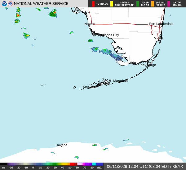
Posted on 9/27/22 at 3:27 pm to Zapps4Life
Maybe I'm going crazy, but that Key West radar looks like it jogs to the west a bit too

Posted on 9/27/22 at 3:27 pm to tgrbaitn08
quote:
You should seen Panama City after Michael....I've never seen any aftermath with the trees like that ever in my life....This will be much worse.
Michael was a Cat 5 strengthening as it went on land... doesn't get worse than that.
Posted on 9/27/22 at 3:28 pm to H2O Tiger
quote:
Maybe I'm going crazy, but that Key West radar looks like it jogs to the west a bit too
A weeble, a wobble
Posted on 9/27/22 at 3:29 pm to H2O Tiger
quote:
Maybe I'm going crazy, but that Key West radar looks like it jogs to the west a bit too
When you can finally watch them so closely those wobbles get really noticeable.
Posted on 9/27/22 at 3:29 pm to ned nederlander
Tampa lost a shitload of trees in 2017 from Irma. Irma's eye crossed I-4 at Plant city. She was a quick moving pig, though. 
This post was edited on 9/27/22 at 3:30 pm
Posted on 9/27/22 at 3:29 pm to H2O Tiger
quote:
Maybe I'm going crazy, but that Key West radar looks like it jogs to the west a bit too
Its going to bounce all over the place. The wobbles matter, but we dont know exactly how yet.
So just take the NHC 6 hour average to smooth the NE to NW bullshite its going to be pulling today. Itll even out to somewhere between N and NNE (tboat's NNNE).

Posted on 9/27/22 at 3:30 pm to IAmNERD
quote:
You staying baw?
Yes
quote:
Aren't y'all near Bradenton now?
I live in east Bradenton
Posted on 9/27/22 at 3:30 pm to adamau


Posted on 9/27/22 at 3:30 pm to Indfanfromcol
Any news from key west?

Posted on 9/27/22 at 3:31 pm to LanierSpots
quote:
I live in east Bradenton
My friend lives in Lakeland.
Good luck.
Posted on 9/27/22 at 3:31 pm to adamau
Yep, it's still less noticeable than the hook I saw (thought I saw) on the cloudcover.

 Page 239 of 465

Popular
Back to top