- My Forums
- Tiger Rant
- LSU Recruiting
- SEC Rant
- Saints Talk
- Pelicans Talk
- More Sports Board
- Coaching Changes
- Fantasy Sports
- Golf Board
- Soccer Board
- O-T Lounge
- Tech Board
- Home/Garden Board
- Outdoor Board
- Health/Fitness Board
- Movie/TV Board
- Book Board
- Music Board
- Political Talk
- Money Talk
- Fark Board
- Gaming Board
- Travel Board
- Food/Drink Board
- Ticket Exchange
- TD Help Board
Customize My Forums- View All Forums
- Show Left Links
- Topic Sort Options
- Trending Topics
- Recent Topics
- Active Topics
Started By
Message
re: Hurricane/Tropical Storm Idalia Discussion Thread
Posted on 8/15/23 at 9:01 am to bbarras85
Posted on 8/15/23 at 9:01 am to bbarras85
quote:
He said a depression which is a thunderstorm more or less. I am pretty sure he said depression just for people like you.
Tropical Depression Allison (downgraded right after landfall) says hello.
LINK
 0
0


Posted on 8/15/23 at 9:15 am to purple18
quote:
With our current drought conditions I'd take a weak Tropical Storm to hit our area.
Hell I'll take a strong one.. IDGAF. No rain in sight here in LC
Posted on 8/15/23 at 9:27 am to notiger1997
quote:
I believe our experts on here have said that the high pressure dome has been key in making sure nothing has formed in the gulf this summer.
That's what I was thinking.
Posted on 8/15/23 at 10:51 am to Dire Wolf
quote:
As I posted on the 1st page, something is coming for the Gulf but details are impossible to work out at this point. Overall, pattern will be pretty favorable but time over water will probably be a big hurdle. Then there will be another possibility in the longer range but confidence is a lot lower.

Posted on 8/15/23 at 11:10 am to rds dc
Come on man.

Posted on 8/15/23 at 11:13 am to ob1pimpbobi
quote:who was saying that this year?
Every Spring we are told the worst hurricane season ever is coming cause climate change

Posted on 8/15/23 at 11:15 am to rds dc

Posted on 8/15/23 at 11:47 am to rds dc
Dr. Levi Cowan
@TropicalTidbits
(1/) The first tropical entity to watch over the next week is a subtle tropical wave currently east of the Leeward Islands.
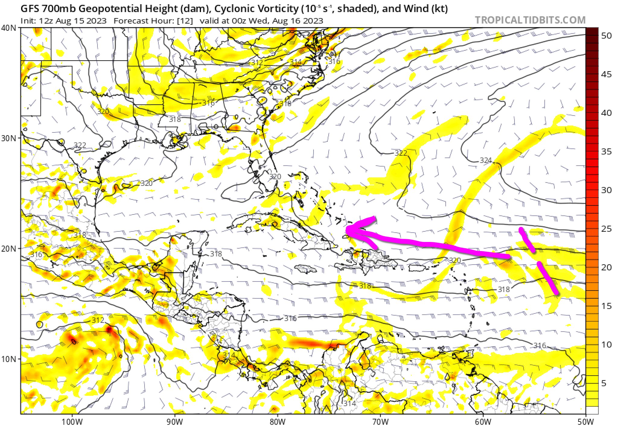
(2/) In terms of thunderstorm activity, there's nothing there on the satellite picture right now, because the wave is embedded within a chunk of the Saharan Air Layer, characterized by an elevated inversion (or two!) that is capping any convection.


(3/) Fast-forward 5 days and this wave is forecast to enter the Gulf of Mexico, where it could find itself beneath a pocket of favorable upper-level flow east of a retreating cutoff low, and with a more favorable background sounding for thunderstorm activity.


(4/) So far, the model signal for any genesis from this wave is pretty weak, with only a small fraction of ensemble members showing development in the western Gulf of Mexico, likely expecting GOM transit to be too quick (~2 days) to allow development.

(5/) However, waves like this should always be watched with at least one eye this time of year, as models can miss short-fused tropical development in the Gulf of Mexico under favorable conditions. At the moment, it is not an imminent concern, but a reminder to be hurricane ready
@TropicalTidbits
(1/) The first tropical entity to watch over the next week is a subtle tropical wave currently east of the Leeward Islands.
(2/) In terms of thunderstorm activity, there's nothing there on the satellite picture right now, because the wave is embedded within a chunk of the Saharan Air Layer, characterized by an elevated inversion (or two!) that is capping any convection.
(3/) Fast-forward 5 days and this wave is forecast to enter the Gulf of Mexico, where it could find itself beneath a pocket of favorable upper-level flow east of a retreating cutoff low, and with a more favorable background sounding for thunderstorm activity.
(4/) So far, the model signal for any genesis from this wave is pretty weak, with only a small fraction of ensemble members showing development in the western Gulf of Mexico, likely expecting GOM transit to be too quick (~2 days) to allow development.
(5/) However, waves like this should always be watched with at least one eye this time of year, as models can miss short-fused tropical development in the Gulf of Mexico under favorable conditions. At the moment, it is not an imminent concern, but a reminder to be hurricane ready

Posted on 8/15/23 at 11:55 am to Jwho77
quote:
(5/) However, waves like this should always be watched with at least one eye this time of year, as models can miss short-fused tropical development in the Gulf of Mexico under favorable conditions. At the moment, it is not an imminent concern, but a reminder to be hurricane ready
Good information. Thanks.
Posted on 8/15/23 at 12:02 pm to Jwho77
quote:
However, waves like this should always be watched with at least one eye this time of year, as models can miss short-fused tropical development in the Gulf of Mexico under favorable conditions. At the moment, it is not an imminent concern, but a reminder to be hurricane ready
I go back to rds mentioning time over water.
If it was a little more organized (even as a wave) once hitting the Gulf, Id be more concerned. Wouldnt be surprised if it was able to go from TD to 50-60 mph TS quick, but questions are big on how long it takes (if at all) to close off a low.
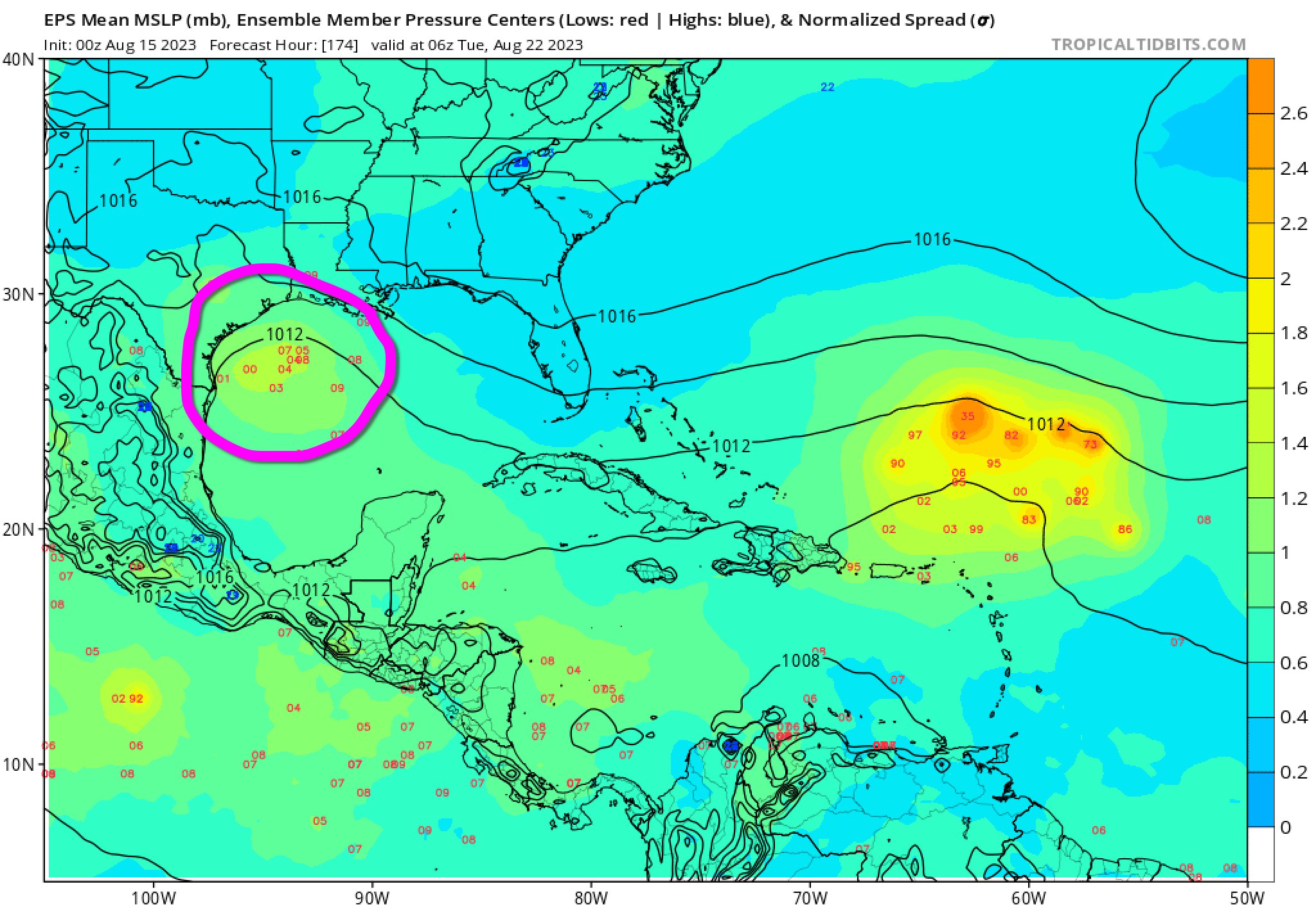
Posted on 8/15/23 at 4:47 pm to Duke
Doesn’t the upper level ridge keep any wave south of Louisiana and southeast Texas ? More like northern Mexico ?

Posted on 8/15/23 at 4:48 pm to Klingler7
That ridge will be eroding over next 1-2 weeks
Posted on 8/15/23 at 4:52 pm to Klingler7
quote:
Doesn’t the upper level ridge keep any wave south of Louisiana and southeast Texas ? More like northern Mexico ?
This first thing should keep going west due to that.
Posted on 8/15/23 at 4:54 pm to Duke
Pat, I would like to buy a half-inch of rainfall please.
This summer set up reminds me of 1980.
This summer set up reminds me of 1980.
This post was edited on 8/15/23 at 4:56 pm

Posted on 8/15/23 at 5:01 pm to Cosmo
quote:
That ridge will be eroding over next 1-2 weeks
Curious - based on what? I have seen it's moving north but not eroding
Posted on 8/15/23 at 6:22 pm to biscuitsngravy
That’s probably what he meant if the ridge moves North that would open the door up for any tropical system to move also north into the gulf coast
Posted on 8/15/23 at 6:34 pm to SWLA92
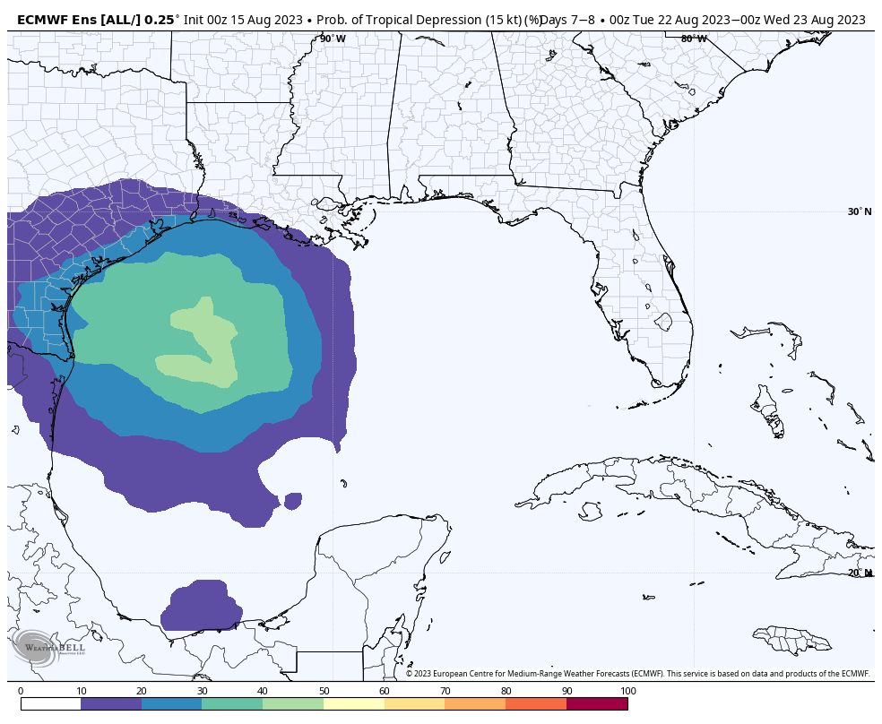
 Western Gulf of Mexico:
 A broad area of low pressure could form in the central or western
Gulf of Mexico by the beginning of next week. Some slow development
of this system is possible thereafter as it moves generally
westward, potentially nearing the western Gulf of Mexico coastline
in about a week.
* Formation chance through 48 hours...low...near 0 percent.
* Formation chance through 7 days...low...20 percent.
$$
Forecaster Papin
This post was edited on 8/15/23 at 6:35 pm
Posted on 8/15/23 at 8:41 pm to lsuman25


Posted on 8/15/23 at 8:53 pm to deltaland
that puppy is gonna be bright red by Friday

Posted on 8/15/23 at 8:57 pm to lsuman25
Hopefully I have another day or two before my wife hears about this

 Page 6 of 139

Back to top