- My Forums
- Tiger Rant
- LSU Recruiting
- SEC Rant
- Saints Talk
- Pelicans Talk
- More Sports Board
- Fantasy Sports
- Golf Board
- Soccer Board
- O-T Lounge
- Tech Board
- Home/Garden Board
- Outdoor Board
- Health/Fitness Board
- Movie/TV Board
- Book Board
- Music Board
- Political Talk
- Money Talk
- Fark Board
- Gaming Board
- Travel Board
- Food/Drink Board
- Ticket Exchange
- TD Help Board
Customize My Forums- View All Forums
- Show Left Links
- Topic Sort Options
- Trending Topics
- Recent Topics
- Active Topics
Started By
Message
re: Hurricane/Tropical Storm Idalia Discussion Thread
Posted on 8/30/23 at 11:22 am to OysterPoBoy
Posted on 8/30/23 at 11:22 am to OysterPoBoy
quote:
I've been begging for a CAD (Cone Accuracy Determination) for years. They won't make it public.
It’s very public…
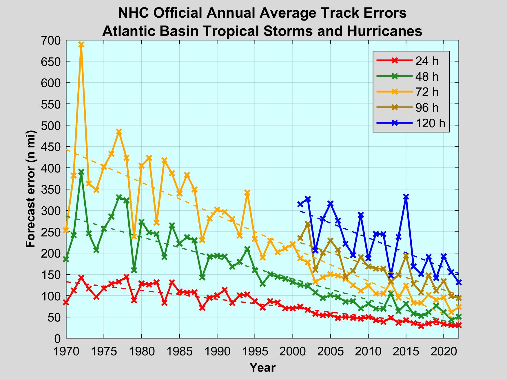
NHC track errors by year - LINK
 2
2

Posted on 8/30/23 at 11:27 am to Veritas
quote:
I’d recommend watching the YouTube channels like Ryan Hall.
With all due respect, Ryan Hall is just as bad:

It’s basically only guys like Levi Cowan and Philippe Papin that you can trust and follow without hyperbole.
This post was edited on 8/30/23 at 11:29 am
Posted on 8/30/23 at 11:28 am to slackster
Pretty impressive they can be 5 days out and now where landfall is going to be within 100 miles.
That kind of accuracy saves lives and gives people time to prepare.
Now we gotta get to point where we can approximate storm strength that far out. Which seems like an impossible task because every storm is different
That kind of accuracy saves lives and gives people time to prepare.
Now we gotta get to point where we can approximate storm strength that far out. Which seems like an impossible task because every storm is different
This post was edited on 8/30/23 at 11:36 am
Posted on 8/30/23 at 11:30 am to slackster
I agree the titles are click baity, but I don’t feel like I’m being yelled at like everything is Armageddon.

Posted on 8/30/23 at 11:30 am to slackster
Holmes beach on Anna Maria Island is under water. A lot of the island has water damage.
That is going to get expensive over there.
That is going to get expensive over there.
Posted on 8/30/23 at 11:32 am to slackster
quote:
It’s very public…
I wonder where those "curves" asymptote at eventually, like theoretically, the lowest the forecast error can go is zero, but that's not reality.

Posted on 8/30/23 at 11:33 am to jfan244888
quote:
Now we gotta get to point where we can approximate storm strength that far out. Which seems like any impossible tasks because every storm is different
definitely, but the models were very good for idalia on this
Posted on 8/30/23 at 11:34 am to jfan244888
quote:
Pretty impressive they can be 5 days out and now where landfall is going to be within 100 miles
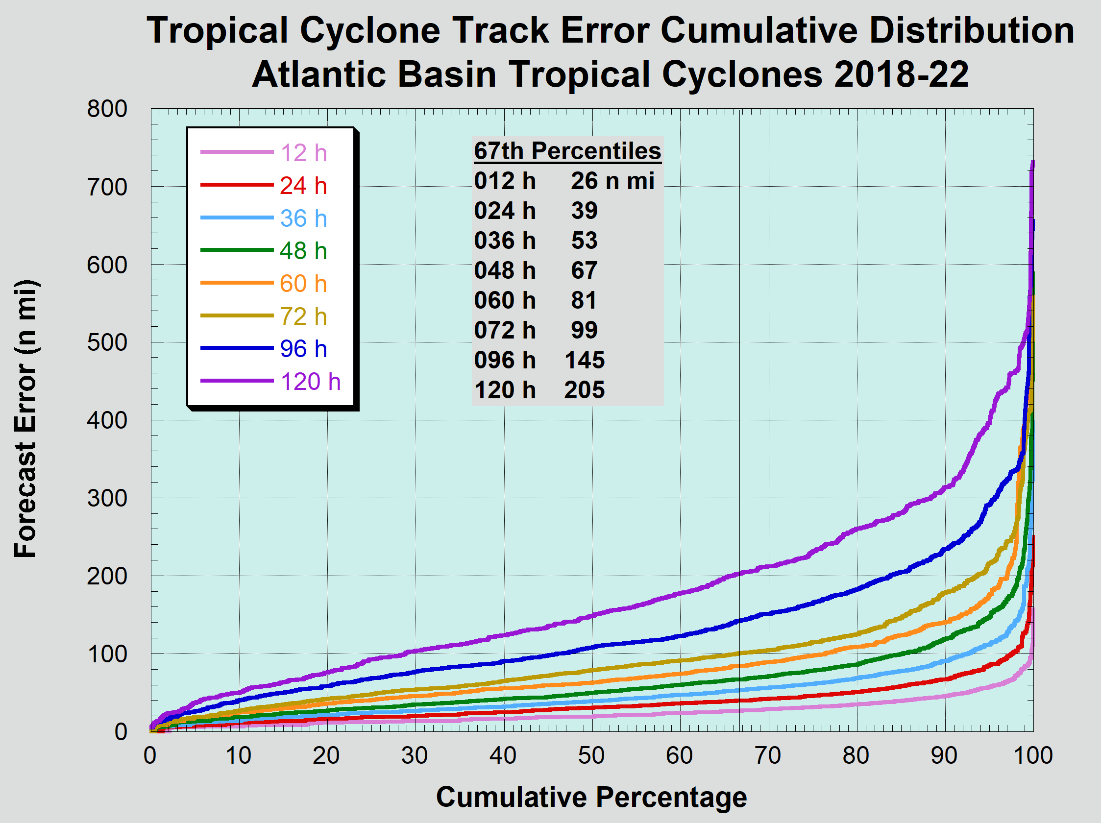
I like this graphic as it eliminates the average which can be skewed by big misses:
quote:
Due to the natural volatility in tropical cyclone track characteristics, annual errors can vary significantly from year to year. For example, years dominated by tracks through the low latitude easterly trade winds typically have relatively small annual errors. Conversely, a relatively large number of forecasts in the mid-latitude westerlies (as can occur during El Ni?o years) can lead to larger errors. Consequently, representative or stable error characteristics must be obtained using a longer period of record. NHC uses a 5-year sample to define its current forecast error characteristics. Average errors for the last 5 period are given below. These verifications follow the procedures given above in Section 2 (i.e., they include the subtropical and depression stages) and the sample is homogeneous with the operational CLIPER5 and Decay-SHIFOR5 models.
They’re also more accurate on hurricanes than they are on tropical storms, but j can’t seem to find the data for that.
Posted on 8/30/23 at 11:35 am to Veritas
quote:
agree the titles are click baity, but I don’t feel like I’m being yelled at like everything is Armageddon.
Yeah I was just catching up with the thread so I see it had been covered.

Posted on 8/30/23 at 11:36 am to slackster
I had to stop giving Ryan Hall clicks... too dramatic.
Someone POW is a good one. I forgot the first part of his handle
Someone POW is a good one. I forgot the first part of his handle

Posted on 8/30/23 at 11:39 am to PureBlood

Posted on 8/30/23 at 11:43 am to alphaandomega
Yeah, Crawfordville has no real problems other than lack of power. I think Perry would be a much better place for you to set up in. Maybe the Walmart Supercenter there if they are OK with it. There are a couple of other strip malls that look like they have large parking lots. I don't know much about Perry other than driving through it several times a year.
Posted on 8/30/23 at 11:44 am to olddawg26
We have had minimal rain in ponte vedra. Some heavy gusts that make you pucker up when you here the trees.
Posted on 8/30/23 at 11:45 am to LanierSpots
You are going to get peak winds at aboot 2 pm up there. 
53 w/66 gusts.
53 w/66 gusts.
Posted on 8/30/23 at 11:46 am to LegendInMyMind
I have had a kind of mist blowing with that last little burst. It could be picking that up on the radar.
This post was edited on 8/30/23 at 11:48 am
Posted on 8/30/23 at 11:51 am to Tvilletiger
quote:
PowerOutage.us
@PowerOutage_us
Over 320k electric customers are without power from #HurricaneIdalia.
275K out in #Florida,
61k out in #Georgia.
[2023-08-30 11:38:41 AM EDT]
LINK
#PowerOutage

Posted on 8/30/23 at 11:56 am to slackster
quote:
It’s basically only guys like Levi Cowan and Philippe Papin that you can trust and follow without hyperbole.
To be fair to that point, both Levi and Philippe are NHC employees. That's where they get their check. They can't risk the dramatics and hysterics.
Mark Sudduth may be the most level headed private sector guy who does actual forecasting out there. He's managed to find a balance that most others haven't. Trey Greenwood (@StormChaseAZ and @ConvChronicles) is Mark's counterpart in severe/tornadic weather.

Posted on 8/30/23 at 11:56 am to TH03
Peak Florida Woman right here: I LOVE DANGER BARBIE
This post was edited on 8/30/23 at 11:57 am
Posted on 8/30/23 at 11:59 am to TH03
quote:
definitely, but the models were very good for idalia on this
As a whole the intensity models struggled big time. Hurricane models did well, but they also at the same time whiffed on Franklin's strength.
This post was edited on 8/30/23 at 12:00 pm
Posted on 8/30/23 at 12:03 pm to LegendInMyMind
978mb/80mph at 1pm edt


 Page 131 of 139

Popular
Back to top