- My Forums
- Tiger Rant
- LSU Recruiting
- SEC Rant
- Saints Talk
- Pelicans Talk
- More Sports Board
- Fantasy Sports
- Golf Board
- Soccer Board
- O-T Lounge
- Tech Board
- Home/Garden Board
- Outdoor Board
- Health/Fitness Board
- Movie/TV Board
- Book Board
- Music Board
- Political Talk
- Money Talk
- Fark Board
- Gaming Board
- Travel Board
- Food/Drink Board
- Ticket Exchange
- TD Help Board
Customize My Forums- View All Forums
- Show Left Links
- Topic Sort Options
- Trending Topics
- Recent Topics
- Active Topics
Started By
Message
re: Hurricane Season - NHC Tracking TD7 but Very Low End Gulf Threat
Posted on 8/24/22 at 12:16 pm to TDsngumbo
Posted on 8/24/22 at 12:16 pm to TDsngumbo
That run stalls it out on the Louisiana coasts for about 48 hrs so that would be a lot of rain
The negative to this run is that’s 2 runs in a row showing a Louisiana landfall, just with 2 different intensities
The negative to this run is that’s 2 runs in a row showing a Louisiana landfall, just with 2 different intensities
 1
1


Posted on 8/24/22 at 12:18 pm to deltaland
Its 11 days out
It will be something completely different by tomorrow
No other model does anything
It will be something completely different by tomorrow
No other model does anything
This post was edited on 8/24/22 at 12:19 pm
Posted on 8/24/22 at 12:29 pm to Cosmo
Will be interesting to see what the next euro does

Posted on 8/24/22 at 12:32 pm to Cosmo
quote:
Its 11 days out It will be something completely different by tomorrow No other model does anything
Well no shite, but it is interesting to see how this runs compares to the previous with the new data, which seem to agree that some kind of system will he in the GOM toward the end of the work week next week.
Posted on 8/24/22 at 12:35 pm to hubertcumberdale
quote:
which seem to agree that some kind of system will he in the GOM toward the end of the work week next week.
This is the kind of breakdown I’m here for.
No clue how to read models or anything

Posted on 8/24/22 at 12:40 pm to Navajo61490
we’ll know more by friday
Posted on 8/24/22 at 12:41 pm to Navajo61490
quote:
This is the kind of breakdown I’m here for. No clue how to read models or anything
I’m pretty novice myself, I have just been watching the GFS model runs when they are released

Posted on 8/24/22 at 12:47 pm to trussthetruzz
quote:
we’ll know more by friday
And the Friday after that we will know even more. Forecasting is easy. Just wait until Friday
Posted on 8/24/22 at 12:47 pm to hubertcumberdale
GEFS favors development even less with the 12z run through 180hrs. Maybe the fewest members yet showing development.
This post was edited on 8/24/22 at 12:48 pm
Posted on 8/24/22 at 2:18 pm to LegendInMyMind
The short version is this:
Whatever state this system is in, its gonna be in the gulf late next week. At least, it looks very likely given the steering.
Right now, significant questions remain on if it develops at all. Hope it fails to ever organize.
Whatever state this system is in, its gonna be in the gulf late next week. At least, it looks very likely given the steering.
Right now, significant questions remain on if it develops at all. Hope it fails to ever organize.
Posted on 8/24/22 at 2:34 pm to hubertcumberdale
I am a degreed meteorologist but I don’t work directly in forecasting. It’s amazing that so many people on this board are weather enthusiasts or meteorologists. When I was a kid 40 years ago, I did not know any friends who were estatic about the weather. Now everyone is a fricking forecaster…lol.
I wish I had free time to stay up all night waiting for a model run to download. Some of these male forecasters get an erection over these weather models.
I wish I had free time to stay up all night waiting for a model run to download. Some of these male forecasters get an erection over these weather models.
This post was edited on 8/24/22 at 2:37 pm
Posted on 8/24/22 at 2:38 pm to Klingler7
quote:
Some of these male forecasters get an erection over these weather models.
I do too but I think we talking about different weather models

Posted on 8/24/22 at 2:39 pm to Klingler7
quote:
Some of these male forecasters get an erection over these weather models.

Posted on 8/24/22 at 2:39 pm to Klingler7
I think some of that is ptsd some is it’s interesting to see how much people know before it’s really if ever publicized. So often the weather threads have been right in seeing a trend a week before it hits the news. Still remember the guy during the Baton Rouge floods that saw the back flooding about to start and ended up helping a shite ton of people on here. Think it ended up saving a bunch of animals.
Posted on 8/24/22 at 3:41 pm to LSU5508
12z euro does nothing with it.
Why are models not developing it? I thought the Caribbean and gulf are pretty favorable right now with low shear. I’m glad they aren’t developing it, I’m just curious what the models think will prevent it
Why are models not developing it? I thought the Caribbean and gulf are pretty favorable right now with low shear. I’m glad they aren’t developing it, I’m just curious what the models think will prevent it
Posted on 8/24/22 at 5:07 pm to deltaland
quote:
Why are models not developing it?
You sound disappointed
Posted on 8/24/22 at 6:06 pm to deltaland
quote:
Why are models not developing it? I thought the Caribbean and gulf are pretty favorable right now with low shear. I’m glad they aren’t developing it, I’m just curious what the models think will prevent it
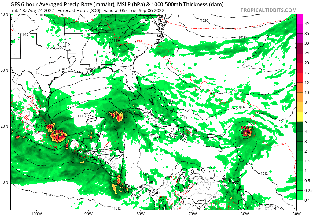
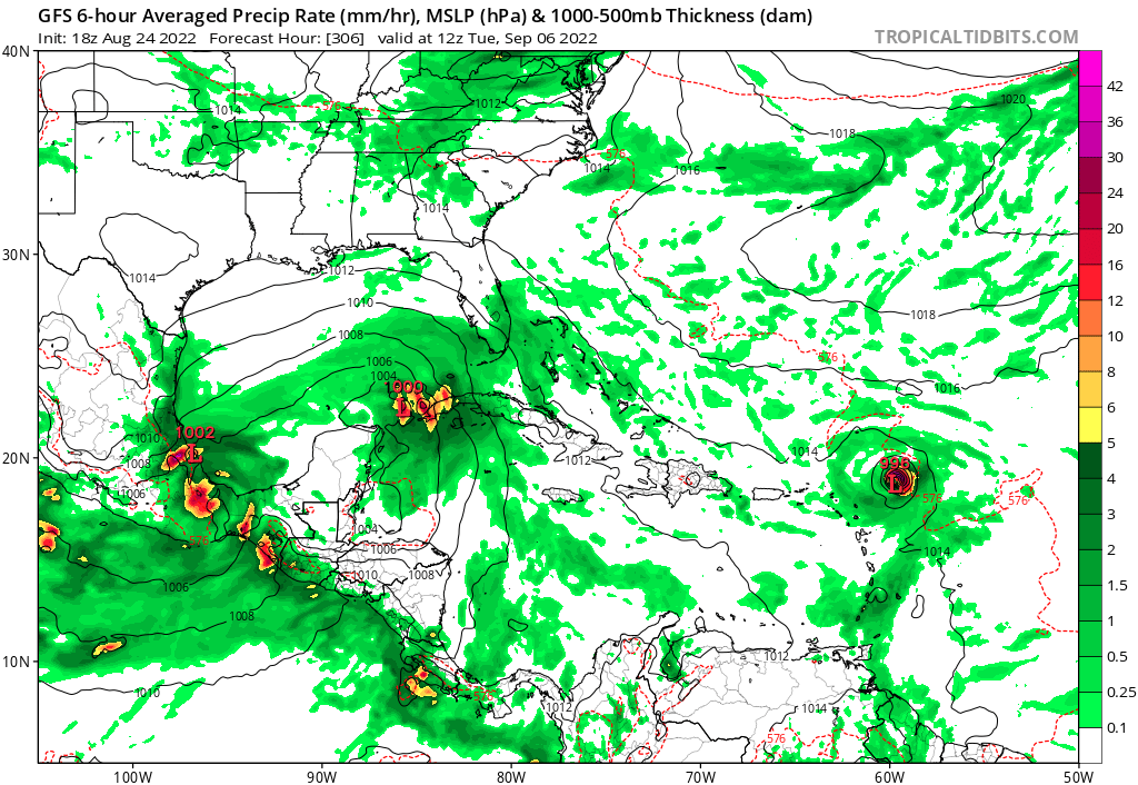
18z run now has this system skirting around the Yucatan Peninsula and heading into Mexico

Posted on 8/24/22 at 6:08 pm to hubertcumberdale
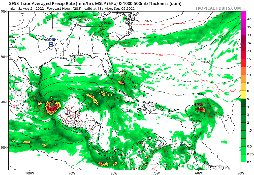
And just like that......two systems. This run actually splits the system in two.
So much for a trend.
So much for a trend.
This post was edited on 8/24/22 at 8:30 pm
Posted on 8/24/22 at 7:04 pm to LegendInMyMind
So based on 24 hours of model data, this forecasted system may threaten South Carolina or Tuxpan, Mexico. Lol
Posted on 8/24/22 at 7:13 pm to LegendInMyMind
The GFS is apparently a piece of shite.

 Page 34 of 71

Popular
Back to top