- My Forums
- Tiger Rant
- LSU Recruiting
- SEC Rant
- Saints Talk
- Pelicans Talk
- More Sports Board
- Fantasy Sports
- Golf Board
- Soccer Board
- O-T Lounge
- Tech Board
- Home/Garden Board
- Outdoor Board
- Health/Fitness Board
- Movie/TV Board
- Book Board
- Music Board
- Political Talk
- Money Talk
- Fark Board
- Gaming Board
- Travel Board
- Food/Drink Board
- Ticket Exchange
- TD Help Board
Customize My Forums- View All Forums
- Show Left Links
- Topic Sort Options
- Trending Topics
- Recent Topics
- Active Topics
Started By
Message
re: Alberto - Steadily Moving Inland
Posted on 5/23/18 at 12:15 pm to lsutiger2010
Posted on 5/23/18 at 12:15 pm to lsutiger2010
[quote]I have a camping trip planned for next weekend around Pensacola. How screwed am I?[/quote]
Considering it’s gay pride weekend in Pensecola, I assume very screwed
Considering it’s gay pride weekend in Pensecola, I assume very screwed
 0
0

Posted on 5/23/18 at 12:18 pm to deuce985
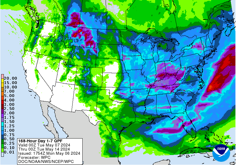
The 0z Euro accumulated rainfall totals. The bulk of the rain in LA falls from midnight Sunday through mid day Thurs.

A long, wet week, but no numbers in LA that should be overwhelming in a short period of time. Still plenty to watch though.
A long, wet week, but no numbers in LA that should be overwhelming in a short period of time. Still plenty to watch though.

Posted on 5/23/18 at 12:28 pm to JohnnyKilroy
quote:
Florida gets hit way more I feel
Yeah, it's Florida and it isn't even close to close.
For Atlantic hurricanes, Florida has been hit 110 times from 1851 to 2004 (NHC dataset). The next closest is... Texas at 59. Louisiana is 3rd at 49. Interestingly enough, North Carolina is 4th at 46.
Hurricanes love blowing America's wang.
This post was edited on 5/23/18 at 2:10 pm
Posted on 5/23/18 at 12:29 pm to slackster
Baton Rouge comes out pretty dry on that run relative to everywhere else.
Since we're not totally dialed in on location of impacts and how long it sticks around, the fact there is 15" plus on that map should have everyone watching from Laffy to the big bend. I do take a bit of comfort that the smart money currently would have a landfall between NOLA and Destin and keep the big rains east of LA.
Since we're not totally dialed in on location of impacts and how long it sticks around, the fact there is 15" plus on that map should have everyone watching from Laffy to the big bend. I do take a bit of comfort that the smart money currently would have a landfall between NOLA and Destin and keep the big rains east of LA.
Posted on 5/23/18 at 12:30 pm to slackster
4-5 inches spread out over 5 days would be amazing. My hay fields will love that shite

Posted on 5/23/18 at 12:33 pm to Duke
Win for th prairie cajuns
Posted on 5/23/18 at 12:35 pm to Duke
quote:
Since we're not totally dialed in on location of impacts and how long it sticks around, the fact there is 15" plus on that map should have everyone watching from Laffy to the big bend. I do take a bit of comfort that the smart money currently would have a landfall between NOLA and Destin and keep the big rains east of LA.
The only real LA concern under the current 0z run is the fact that you'd have due south winds for the better part of 5 days. There would be plenty of moisture and the potential for locally heavy rains.
Your point about the exact location is a good one. No one should focus on exact rainfall totals at this point.

Posted on 5/23/18 at 12:39 pm to FairhopeTider
quote:
James Spann is pretty bad at this. He can be pretty smug and he will unleash his hordes of followers on anyone that questions him.
I like James, but he will give broad forecasts about snow totals, tornadoes, and somewhat hurricanes (not as much emphasis since located in Birmingham).
This way he is covered by being able to state after the fact, that they were within the forecast.

Posted on 5/23/18 at 12:41 pm to JohnnyKilroy
quote:
Florida gets hit way more I feel
Florida gets hit almost exclusively in May and June because the steering currents, fronts and the jet stream, drive the storms eastward and into Florida. Which is why chances are good this one get driven into Florida.
Posted on 5/23/18 at 12:41 pm to slackster
quote:
The only real LA concern under the current 0z run is the fact that you'd have due south winds for the better part of 5 days. There would be plenty of moisture and the potential for locally heavy rains.
Yeah, the pull out of the south has be a bit concerned but the PWAT won't be out of control like if the gulf was sitting about 88-90 right now. We could use a spread out wet period around here anyway.
Hopefully the 0z runs tonight have a decent sample of that subtropical jet and upper low about to kick into play (LIX discussion ran it down excellently this morning). Should (hopefully) get a tighter spread on the models to start getting good rainfall predictions.
Posted on 5/23/18 at 1:24 pm to Duke
NOLA spared? That Latoya is Fiya!
This post was edited on 5/23/18 at 1:25 pm
Posted on 5/23/18 at 1:32 pm to Chad504boy
12z Euro running now. It's got the system getting about 75 miles due south of the mouth of the river Sunday at 10AM, then meandering slowly due west until it's due south of Houma after 24 hours.
Still running.
Still running.
Posted on 5/23/18 at 1:34 pm to Chad504boy
Euro 12z run has it stalling off the coast of Louisiana. Seems several models are showing some sorta stall near/after landfall even if they can't agree on where landfall will be. Worst case for rain totals.
Posted on 5/23/18 at 1:40 pm to ABucks11
Sunday Morning

Monday Morning:

Tuesday Morning:

Wednesday Morning:

Monday Morning:
Tuesday Morning:
Wednesday Morning:
Posted on 5/23/18 at 1:43 pm to ABucks11
as long as it is not 25-30 inches in 2-3 days I would think most of us would be ok.
Posted on 5/23/18 at 1:44 pm to slackster
By Wednesday morning the Euro has it moving out of here pretty quickly, getting here by Thursday morning:

Posted on 5/23/18 at 1:59 pm to slackster
Heavier rain chances have moved closer to LA, but the overall totals are lower and the coverage of the state is lower too.

Posted on 5/23/18 at 2:02 pm to slackster
Also, the 12z run ends up with heavier and more widespread totals in Alabama, Florida, and Georgia.
Pretty solid bet the SE is going to get quite a bit of rain over the next week.
Pretty solid bet the SE is going to get quite a bit of rain over the next week.

Posted on 5/23/18 at 2:17 pm to slackster
Was it expected for 90L to wind up in the Yucatan??
Posted on 5/23/18 at 2:28 pm to 50_Tiger
quote:
Dylan Federico
? @DylanFedericoWx
12z EURO shows 90L meandering around the Louisiana/Mississippi coast for 3 to 4 days, posing the risk for significant rainfall totals & coastal flooding with #90L. Looking at the 500mb heights, it's plain as day! There really isn't a weakness to pick it up early next week! #lawx
Dylan needs to switch to decaf if he expects to make it in this business. One thing a pro met can't be is prone to hysterics. This shite may pan out exactly like he says, but five days away is not the time to be making predictions like this.

 Page 15 of 57

Popular
Back to top