- My Forums
- Tiger Rant
- LSU Recruiting
- SEC Rant
- Saints Talk
- Pelicans Talk
- More Sports Board
- Fantasy Sports
- Golf Board
- Soccer Board
- O-T Lounge
- Tech Board
- Home/Garden Board
- Outdoor Board
- Health/Fitness Board
- Movie/TV Board
- Book Board
- Music Board
- Political Talk
- Money Talk
- Fark Board
- Gaming Board
- Travel Board
- Food/Drink Board
- Ticket Exchange
- TD Help Board
Customize My Forums- View All Forums
- Show Left Links
- Topic Sort Options
- Trending Topics
- Recent Topics
- Active Topics
Started By
Message
re: Hurricane Nate - Moving Inland - Hurricane Season Over?
Posted on 10/6/17 at 9:34 am to rds dc
Posted on 10/6/17 at 9:34 am to rds dc
quote:
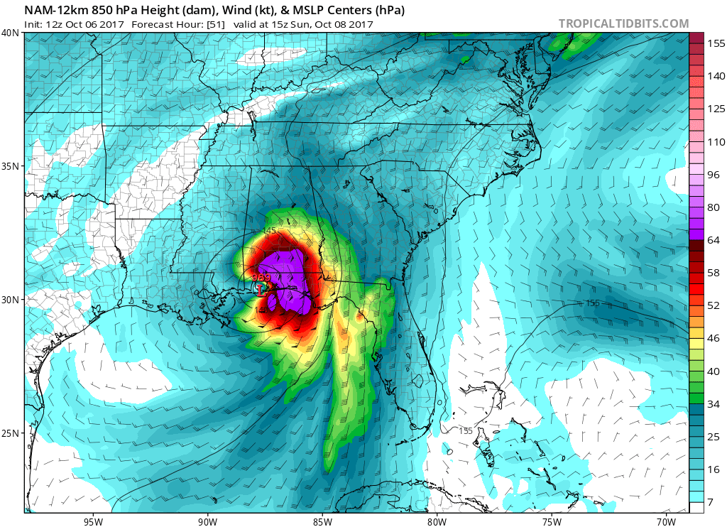
Honestly, I don't know a whole lot about the NAMs. The 12k is the parent domain and the 3k is run within that domain over a smaller area called a nest. The 3k allows for convection. The issues are probably related to the fact that Nate is near the edge of the nest and the model is over doing convection associated with Nate.
Appreciate the insight.
 0
0


Posted on 10/6/17 at 9:35 am to rds dc

Posted on 10/6/17 at 9:37 am to rds dc
Those GOES images give me a chubby.
Best satellite ever.
Best satellite ever.
Posted on 10/6/17 at 9:38 am to theOG
A quick glance at the models shows a fairly big shift east. Euro seems to be holding firm west but with this storm it seems to be late on trends and isn't following how it performed the rest of season. Wondering if they're going to stay east.
Posted on 10/6/17 at 9:39 am to deuce985
quote:
A quick glance at the models shows a fairly big shift east. Euro seems to be holding firm west
weird cause wasn't Euro the one that was originally East?

Posted on 10/6/17 at 9:43 am to deuce985
If Euro moves significantly east at 12z, then we might have something.
Posted on 10/6/17 at 9:45 am to Chad504boy
Yeah and it was basically the outlier in the models until it started shifting west too. It's doing the same thing here basically. I wouldn't be surprised to see it shift east too.
That said, wouldn't surprise me to see it go west based on how these models are going too. We're less than 48 hours from a landfall and they still haven't completely ironed a small area out yet. They have been consistent on anywhere from Morgan City to Pensacola though.
That said, wouldn't surprise me to see it go west based on how these models are going too. We're less than 48 hours from a landfall and they still haven't completely ironed a small area out yet. They have been consistent on anywhere from Morgan City to Pensacola though.
This post was edited on 10/6/17 at 9:48 am
Posted on 10/6/17 at 9:45 am to deuce985
quote:
Euro seems to be holding firm west but with this storm it seems to be late on trends and isn't following how it performed the rest of season. Wondering if they're going to stay east.
The Euro initialized over 12 hours ago at this point, so it makes sense that it's a bit west of the eastern shifts we've seen since then. The Euro operational run was also on the western edge of the ensemble members, so we'll see where the 12z run comes in this afternoon.
Euro ensembles:

Posted on 10/6/17 at 9:46 am to GEAUXmedic
quote:
If Euro moves significantly east at 12z, then we might have something.
Dumb question, but when does this come out?
Posted on 10/6/17 at 9:46 am to slackster
I just realized, I think this is the first season in my entire existence on this planet (31 years) where every single part of the Gulf Coast has been hit with some part of a Hurricane or taken a direct hit.
DARPA working round the clock lol jk.
DARPA working round the clock

Posted on 10/6/17 at 9:47 am to CBDTiger
quote:No offense, but we here in Pensacola say frick that shite
For now, we hope the eastern shift continues.
Posted on 10/6/17 at 9:48 am to Chad504boy
quote:
weird cause wasn't Euro the one that was originally East?
Yes, but the reason the Euro was east then is different than why the other models have shifted east here recently.
Posted on 10/6/17 at 9:49 am to dukke v
quote:
it looks like NOLA could take A direct hit
quote:
dukke v
never forget
Posted on 10/6/17 at 9:49 am to rds dc
quote:
reason the Euro was east then is different than why the other models have shifted east here recently.
Has this been covered in previous posts? What is steering the east shift?

Posted on 10/6/17 at 9:49 am to rocket31
Posted on 10/6/17 at 9:50 am to rocket31
Posted on 10/6/17 at 9:50 am to Mr. Hangover
quote:
we are all having a hurricane party down here in plaquemines
Good luck getting out of Lake Hermitage in the next week.. The water was already high when I was back there yesterday afternoon..
Posted on 10/6/17 at 9:50 am to deuce985
quote:
How's the system looking today? Better organized? Not as organized as thought?
It's better organized, but that was expected. As rds mentioned earlier, it's still entrenched in the larger "gyre", so it's had trouble building convection in the NE quadrant. Most of those storms are staying well away from the center and being pulled away by the convection near Cuba.

In the last few frames it looks like some of the convection from the SE is starting to wrap around into the NE, but we'll see if it materializes. It's got pretty good outflow to the west and south, so it may be trying to make a run here.
Posted on 10/6/17 at 9:51 am to FearlessFreep
You guys are going to get it over there regardless but I understand what you mean. A 50 miles difference on where it hits makes a huge impact for areas around it. I just hope it doesn't directly hit New Orleans. I think most people in that area would rather not see if they need to trust the pumps considering their problems.
Posted on 10/6/17 at 9:51 am to jorconalx
quote:
Dumb question, but when does this come out?
12:45 ish CDT.

 Page 79 of 193

Popular
Back to top