- My Forums
- Tiger Rant
- LSU Recruiting
- SEC Rant
- Saints Talk
- Pelicans Talk
- More Sports Board
- Coaching Changes
- Fantasy Sports
- Golf Board
- Soccer Board
- O-T Lounge
- Tech Board
- Home/Garden Board
- Outdoor Board
- Health/Fitness Board
- Movie/TV Board
- Book Board
- Music Board
- Political Talk
- Money Talk
- Fark Board
- Gaming Board
- Travel Board
- Food/Drink Board
- Ticket Exchange
- TD Help Board
Customize My Forums- View All Forums
- Show Left Links
- Topic Sort Options
- Trending Topics
- Recent Topics
- Active Topics
Started By
Message
re: Hurricane Milton - The Cleanup Begins...
Posted on 10/9/24 at 7:51 am to ell_13

Posted on 10/9/24 at 7:51 am to ell_13
Andrew RMW was 11 miles at landfall
Milton was 9 at last update that I can see at least.
Why do y’all have a problem with everything I say? I was addressing a post comparing Milton to Katrina which is ridiculous.
I never said it wouldn’t be a major.
Milton was 9 at last update that I can see at least.
Why do y’all have a problem with everything I say? I was addressing a post comparing Milton to Katrina which is ridiculous.
quote:
Yes it will weaken but the data you posted still has it as a major hurricane when it hits. Maybe even still a 4. Just so you’re aware… 115kt is a Cat4.
I never said it wouldn’t be a major.
This post was edited on 10/9/24 at 8:23 am
 5
5


Posted on 10/9/24 at 7:55 am to rds dc

Posted on 10/9/24 at 7:57 am to rmnldr
quote:I have already explained why these aren’t comparable. We are talking about Milton’s expansion at landfall. It’s not like Andrew.
Andrew RMW was 11 miles at landfall
Milton was 13 at last update that I can see at least.
quote:Am I wrong? The Katrina comparison has to do with dropping quickly from a 5 to a 3 with an ever expanding wind field and what that means for surge. It is certainly applicable here. Is it quite as large? No. But the behavior is going to be very similar. You missed that point.
Why do y’all have a problem with everything I say? I was addressing a post comparing Milton to Katrina which is ridiculous.
Posted on 10/9/24 at 7:58 am to rmnldr
quote:
Why do y’all have a problem with everything I say? I was addressing a post comparing Milton to Katrina which is ridiculous.
You’re fine man. There are some panicky arse people in these threads. Appreciate the insight.
Posted on 10/9/24 at 8:00 am to Roll Tide Ravens
Hurricane Milton Tropical Cyclone Update
NWS National Hurricane Center Miami FL AL142024
900 AM EDT Wed Oct 09 2024
...PREPARATIONS SHOULD BE RUSHED TO COMPLETION THIS MORNING...
...900 AM EDT POSITION UPDATE...
Now is the time to rush to complete all preparations to protect life
and property in accordance with your emergency plan. Ensure you are
in a safe location before the onset of strong winds or possible
flooding. Ensure you have multiple ways to receive weather warnings.
Another position update will be provided at 1000 AM EDT (1400 UTC).
SUMMARY OF 900 AM EDT...1300 UTC...INFORMATION
-----------------------------------------------
LOCATION...25.3N 84.6W
ABOUT 115 MI...185 KM WNW OF THE DRY TORTUGAS
ABOUT 230 MI...365 KM SW OF TAMPA FLORIDA
MAXIMUM SUSTAINED WINDS...155 MPH...250 KM/H
PRESENT MOVEMENT...NE OR 40 DEGREES AT 16 MPH...26 KM/H
MINIMUM CENTRAL PRESSURE...918 MB...27.11 INCHES
$$
Forecaster Kelley
Posted on 10/9/24 at 8:01 am to Roll Tide Ravens
From NHC’s discussion on the 4 AM advisory:
Milton's wind field is expected to grow considerably in size while
it moves across Florida. Additionally, a large region of tropical
storm and hurricane-force winds could occur on the northwest/back
side of the storm since Milton will be interacting with a frontal
boundary and beginning extratropical transition. Damaging winds,
life-threatening storm surge, and heavy rainfall will extend well
outside the forecast cone. This is a very serious situation and
residents in Florida should closely follow orders from their local
emergency management officials. Evacuations and other preparations
should be rushed to completion. Milton has the potential to be one
of the most destructive hurricanes on record for west-central
Florida.
Posted on 10/9/24 at 8:04 am to rmnldr
quote:This is why we are arguing. But I digress.
NHC isn’t predicting a dramatic enlargement of the wind field before landfall:
DRY AIR ENGAGED!!
Posted on 10/9/24 at 8:04 am to rmnldr
quote:youre going to get your own bingo square at this rate
rmnldr
Posted on 10/9/24 at 8:04 am to tiger1969
I got all my debris picked up luckily yesterday but Tampas a whole other story.
Posted on 10/9/24 at 8:06 am to rmnldr
Enough with the katrina dick measuring contests
Posted on 10/9/24 at 8:07 am to UnitedFruitCompany
quote:
Peej already sealed Tampa's fate.
Normally I would just take some shrooms, chain myself to the column of a large bridge, and bark at the storm as it rolls in
Given the juju Peej dropped, I’m gonna head to the Indian mound to naked dance this storm into submission as best I can. This would be more effective if there is someone doing the same at another mound further south.
Anyone near the Portavant mound have natural hallucinogens, a drum, and Florida nuts?
Posted on 10/9/24 at 8:07 am to ell_13
quote:
I have already explained why these aren’t comparable. We are talking about Milton’s expansion at landfall. It’s not like Andrew.
I have never said that Milton would be comparable to Andrew at landfall.
Everything I have said is about the size of Milton currently. Right now it’s undergoing its ERC and expanding its wind field. Its impacts will not be similar to Andrew and will generate more surge.
quote:
Am I wrong? The Katrina comparison has to do with dropping quickly from a 5 to a 3 with an ever expanding wind field and what that means for surge. It is certainly applicable here. Is it quite as large? No. But the behavior is going to be very similar. You missed that point.
Yeah, you are. Anyone comparing this storm to Milton outside of what they’ll do on the Saffir-Simpson scale is misleading people.
Katrina had days in the gulf with a wind field double or triple the size of Milton to generate storm surge and finally before landfall Katrina opened up with 100mi radius hurricane force winds to put the icing on top. Milton has had 8mi wind radius for days and will only be opening up right before landfall. The two aren’t comparable at all. You’re not going to see 30 foot storm surge being generated by this. Location of the on-shore winds will matter the most in terms of surge impact and the underwater geography/existence of bays/inlets but this is not a large hurricane by any means and won’t ever become one.
Once again, not downplaying. It’s going to have severe impacts, but relatively speaking, it’s not a “monster” storm by any measure outside of wind speed and pressure.
ETA: I apologize to the fine folks of the board, I’m going to observe now.
This post was edited on 10/9/24 at 8:11 am

Posted on 10/9/24 at 8:09 am to Roll Tide Ravens
Waiting for this dry air to penetrate ANY TIME NOW 
Posted on 10/9/24 at 8:09 am to Roll Tide Ravens
Eyewall on west side getting ripped apart
This may weaken faster than expected I hope
This may weaken faster than expected I hope

Posted on 10/9/24 at 8:10 am to rmnldr
Who gives a frick about a storm from 20 years ago. This topic is about an active storm.

Posted on 10/9/24 at 8:11 am to cgrand
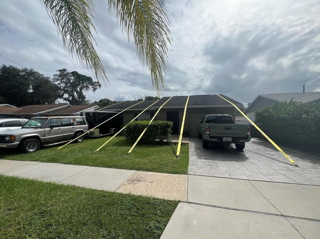
We’re locked in and ready for Milton 
Posted on 10/9/24 at 8:13 am to hg
What are those straps for?
Posted on 10/9/24 at 8:14 am to hg
That would absolutely be me if I lived near the coast. I would probably add some protection at the top of the gable though.
Posted on 10/9/24 at 8:14 am to Billy Blanks
Ratchet Straps to save the roof obv!
Posted on 10/9/24 at 8:14 am to Billy Blanks
Pressure up to 923 on last recon pass. All good things.

 Page 164 of 242

Popular
Back to top