- My Forums
- Tiger Rant
- LSU Recruiting
- SEC Rant
- Saints Talk
- Pelicans Talk
- More Sports Board
- Coaching Changes
- Fantasy Sports
- Golf Board
- Soccer Board
- O-T Lounge
- Tech Board
- Home/Garden Board
- Outdoor Board
- Health/Fitness Board
- Movie/TV Board
- Book Board
- Music Board
- Political Talk
- Money Talk
- Fark Board
- Gaming Board
- Travel Board
- Food/Drink Board
- Ticket Exchange
- TD Help Board
Customize My Forums- View All Forums
- Show Left Links
- Topic Sort Options
- Trending Topics
- Recent Topics
- Active Topics
Started By
Message
 1
1


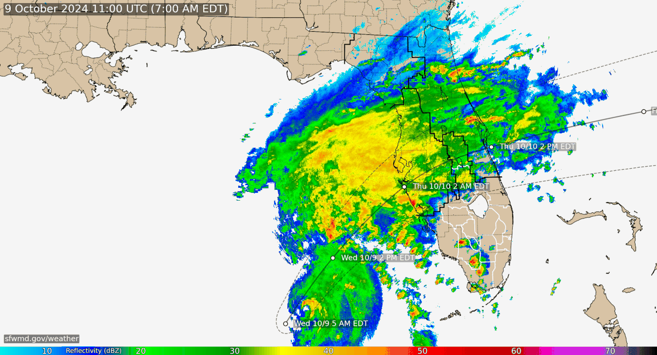
Posted on 10/9/24 at 7:26 am to ell_13
NHC isn’t predicting a dramatic enlargement of the wind field before landfall:
It’s also highly asymmetrical with the shear. The furthest extent of hurricane-force winds will be in the south east quadrant.
quote:
HURRICANE CENTER LOCATED NEAR 24.5N 85.4W AT 09/0900Z
POSITION ACCURATE WITHIN 10 NM
PRESENT MOVEMENT TOWARD THE NORTHEAST OR 45 DEGREES AT 12 KT
ESTIMATED MINIMUM CENTRAL PRESSURE 907 MB
EYE DIAMETER 10 NM
MAX SUSTAINED WINDS 140 KT WITH GUSTS TO 170 KT.
64 KT....... 25NE 25SE 25SW 25NW.
50 KT....... 45NE 50SE 50SW 50NW.
34 KT.......100NE 100SE 100SW 110NW.
12 FT SEAS..150NE 150SE 360SW 360NW.
WINDS AND SEAS VARY GREATLY IN EACH QUADRANT. RADII IN NAUTICAL
MILES ARE THE LARGEST RADII EXPECTED ANYWHERE IN THAT QUADRANT.
REPEAT...CENTER LOCATED NEAR 24.5N 85.4W AT 09/0900Z
AT 09/0600Z CENTER WAS LOCATED NEAR 23.8N 85.9W
FORECAST VALID 09/1800Z 25.9N 84.3W
MAX WIND 130 KT...GUSTS 160 KT.
64 KT... 30NE 30SE 30SW 30NW.
50 KT... 50NE 50SE 50SW 50NW.
34 KT...130NE 120SE 100SW 130NW.
FORECAST VALID 10/0600Z 27.4N 82.6W...INLAND
MAX WIND 115 KT...GUSTS 140 KT.
64 KT... 35NE 35SE 35SW 40NW.
50 KT... 70NE 60SE 60SW 70NW.
34 KT...180NE 140SE 100SW 150NW.
It’s also highly asymmetrical with the shear. The furthest extent of hurricane-force winds will be in the south east quadrant.
Posted on 10/9/24 at 7:26 am to rmnldr
quote:
Milton has 50 mile wide hurricane wind field in diameter
Katrina had 200
This isn’t comparable AT ALL.
Milton is more comparable to Camille, a tighter smaller storm, but strong as shite.
Posted on 10/9/24 at 7:28 am to rmnldr
IFR looks to be showing some dry air being pulled in on the southern end too

Posted on 10/9/24 at 7:28 am to Hangover Haven
Tornado watch just popped up
Tornado Watch
Issued: 8:20 AM Oct. 9, 2024 – National Weather Service
THE NATIONAL WEATHER SERVICE HAS ISSUED TORNADO WATCH 690 IN
EFFECT UNTIL 9 PM EDT THIS EVENING FOR THE FOLLOWING AREAS
IN FLORIDA THIS WATCH INCLUDES 5 COUNTIES
IN EAST CENTRAL FLORIDA
INDIAN RIVER MARTIN OKEECHOBEE
OSCEOLA ST. LUCIE
THIS INCLUDES THE CITIES OF BASINGER, BASSWOOD ESTATES, CELEBRATION, COUNTRY HILLS ESTATES, DEER PARK, FORT DRUM, FORT PIERCE, FOUR SEASONS ESTATES, GROVENOR ESTATES, HOBE SOUND, HOBE SOUND BEACH, INDIANTOWN, JAYCEE BEACH, JENSEN BEACH, KISSIMMEE PRAIRIE PRESERVE, OKEECHOBEE, PALM CITY, PORT SAINT LUCIE, PORT SALERNO, SEBASTIAN, SEBASTIAN INLET, STUART, VERO BEACH, VERO BEACH SOUTH, AND VERO LAKE ESTATES.
Posted on 10/9/24 at 7:29 am to rmnldr
quote:to this
64 KT....... 25NE 25SE 25SW 25NW
quote:Is a 50% increase. You’re saying they’re NOT predicting a wind field expansion??
64 KT... 35NE 35SE 35SW 40NW.

Posted on 10/9/24 at 7:31 am to IT_Dawg
quote:
I am guessing landfall near Sarasota or just North of there.
Basically going right through Longboat Key.
Posted on 10/9/24 at 7:34 am to Hangover Haven
Yeah sort of. Camille had a 100 mile wide wind field. Milton is smaller than that.
It’s most similar to Andrew in size:
Andrew

Milton

It’s most similar to Andrew in size:
Andrew
Milton

Posted on 10/9/24 at 7:36 am to ell_13
Wind field should increase as it weakens and unwinds.
The way the eye is right now on radar is one of those with a narrow intense wind fields that gives where ever it hits a Mexican vasectomy. But places 30 miles up the road get a stiff breeze.
The way the eye is right now on radar is one of those with a narrow intense wind fields that gives where ever it hits a Mexican vasectomy. But places 30 miles up the road get a stiff breeze.
Posted on 10/9/24 at 7:36 am to ell_13
quote:
Is a 50% increase. You’re saying they’re NOT predicting a wind field expansion??
That’s not dramatic. That’s going to come with significant weakening as well. This is in reference to a post comparing Katrina to Milton.
I never said they weren’t predicting a wind field expansion. I’ve literally been posting the graphics of the wind field expansion happening.
Posted on 10/9/24 at 7:39 am to rmnldr
Milton is still riding southeast of the cone
Posted on 10/9/24 at 7:39 am to IT_Dawg
quote:
reload that satellite image...the very last 2 ticks are showing signs Milton starting to regain his eye.
I’m impressed by how close the eye is to what appears to be the northern edge of the storm.
Posted on 10/9/24 at 7:40 am to ell_13
I haven’t read the steering forecast in a bit but they must be predicting a slowdown in forward speed as it turns east. As it stands now it’s only 12.5 hours out from Tampa (200 miles at 16 mph), but they’re showing landfall closer to midnight.
Posted on 10/9/24 at 7:40 am to rmnldr
quote:You compared it to Andrew at landfall. It will be twice the size as Andrew by volume when it hits. I know what you’re posting. Do you?
This is in reference to a post comparing Katrina to Milton.
Yes it will weaken but the data you posted still has it as a major hurricane when it hits. Maybe even still a 4. Just so you’re aware… 115kt is a Cat4.
This post was edited on 10/9/24 at 7:42 am
Posted on 10/9/24 at 7:46 am to slackster
quote:
I haven’t read the steering forecast in a bit but they must be predicting a slowdown in forward speed as it turns east. As it stands now it’s only 12.5 hours out from Tampa (200 miles at 16 mph), but they’re showing landfall closer to midnight.
It will slow down just a little as it gets closer to land, and its going 14mph, not 16 according to the 8am advisory. Also, its not taking a bird path to Tampa, it will have kind of an arc to it, so it will travel further than 200 miles
This post was edited on 10/9/24 at 7:49 am

Posted on 10/9/24 at 7:47 am to ell_13
Weather nerd arguments are the best arguments.
Posted on 10/9/24 at 7:47 am to rmnldr
At this point the main thing that will determine landfall location is when the bend back to the right begins.
Posted on 10/9/24 at 7:50 am to slackster
There’s going to be shite everywhere after this storm
On the news they keep showing this debris drop off area by the amphitheater in Tampa. It’s just a huge pile of crap right next to the interstate.
On the news they keep showing this debris drop off area by the amphitheater in Tampa. It’s just a huge pile of crap right next to the interstate.
Posted on 10/9/24 at 7:50 am to AllDayEveryDay
Not necessarily directed to you AllDay, but anyone in general who can answer this. With the mandatory evacuations, can we expect any of the storm chasers to be near ground zero for this one, or will they be more on the outer fringes?
Posted on 10/9/24 at 7:50 am to ell_13
quote:
The wind field is going to get much larger at it will be impacted by shear/cold front.
True
As it approaches land, the wind field will expand.
Milton does not look to be as large a system as Katrina though so I’m guessing the expansion will be less.?
This post was edited on 10/9/24 at 7:59 am

 Page 163 of 242

Popular
Back to top