




 0
0






- My Forums
- Tiger Rant
- LSU Recruiting
- SEC Rant
- Saints Talk
- Pelicans Talk
- More Sports Board
- Fantasy Sports
- Golf Board
- Soccer Board
- O-T Lounge
- Tech Board
- Home/Garden Board
- Outdoor Board
- Health/Fitness Board
- Movie/TV Board
- Book Board
- Music Board
- Political Talk
- Money Talk
- Fark Board
- Gaming Board
- Travel Board
- Food/Drink Board
- Ticket Exchange
- TD Help Board
Customize My Forums- View All Forums
- Show Left Links
- Topic Sort Options
- Trending Topics
- Recent Topics
- Active Topics
Started By
Message
re: Hurricane Isaias - Pensacola Beach to Navarre Beach Under the Gun
Posted on 10/9/26 at 1:47 pm to LSU=Champions
Posted on 10/9/26 at 1:47 pm to LSU=Champions
That lowest pressure was located at 87.1 West - so another tenth east from 1 PM advisory.
That is just east of Gulf Breeze and due south of Oriole Beach / Tiger Point for those familiar.
That is just east of Gulf Breeze and due south of Oriole Beach / Tiger Point for those familiar.
This post was edited on 10/9/26 at 1:48 pm
Posted on 10/9/26 at 1:48 pm to SippyCup
The lightning on this is nonstop. It will be headed, eventually, to the areas south of Tallahassee.
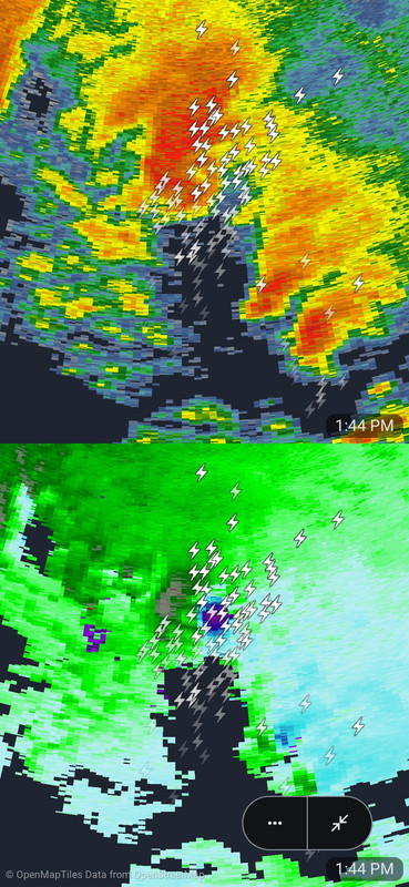
It is no doubt putting down a waterspout right now.
It is no doubt putting down a waterspout right now.
This post was edited on 10/9/26 at 1:49 pm
Posted on 10/9/26 at 1:49 pm to ArHog
Posted on 10/9/26 at 1:50 pm to LegendInMyMind
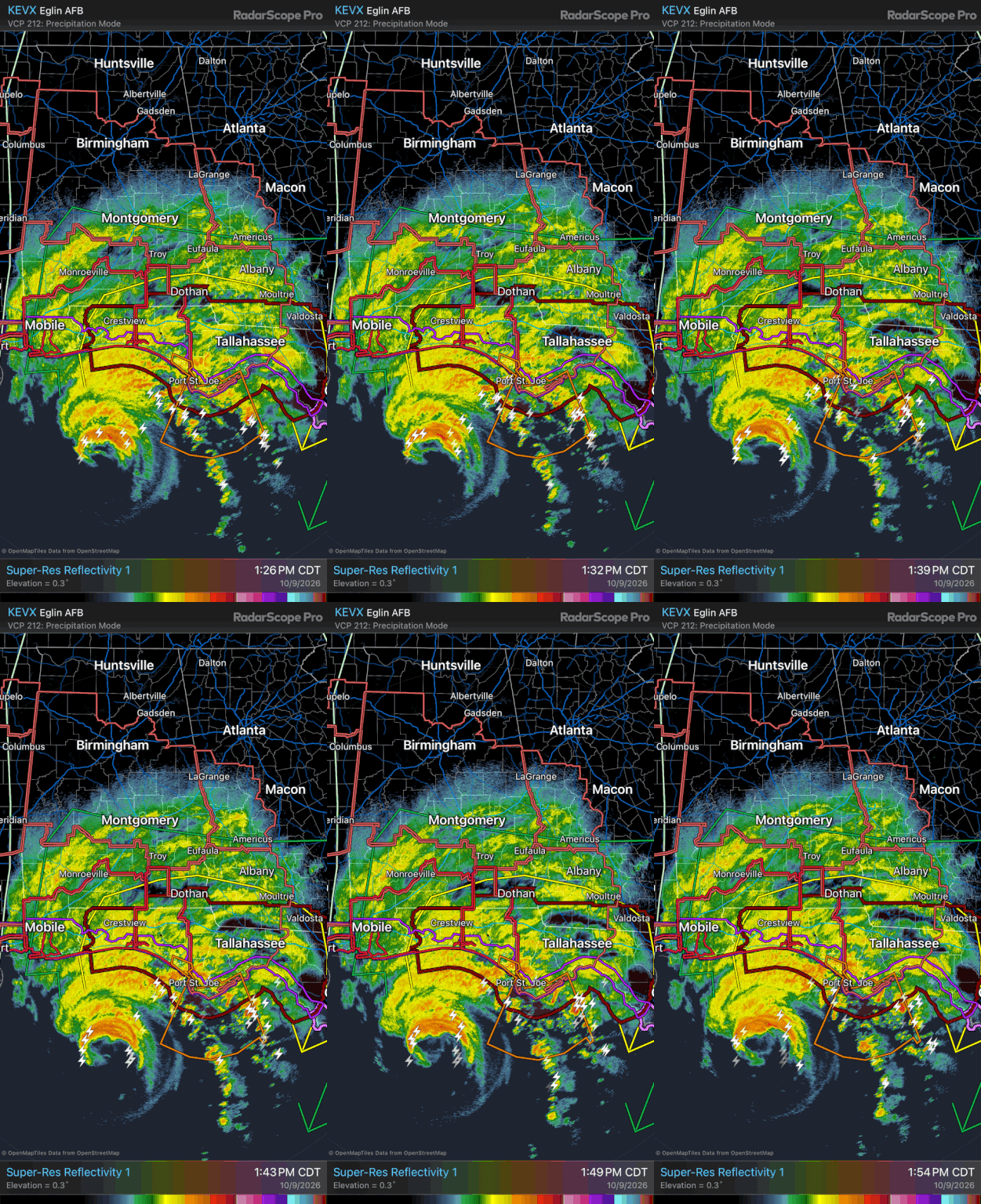
Southern portion of the eyewall disappeared on reflectivity. Not sure if that’s just because of the beam height or the northern wall blocking it or if the dry air and shear collapsed the convection
Posted on 10/9/26 at 1:50 pm to LSU=Champions
That really sucks
Posted on 10/9/26 at 1:50 pm to Master Guilbeau
Ah, OK.
For some reason, that has always bugged me.
Gulf Breeze is a very small place. It encompasses the Naval Live Oaks are but doesn't extend east of there.
I'm not sure why people won't use another name to describe the area where they live. This seems to be very common in that area.

For some reason, that has always bugged me.
Gulf Breeze is a very small place. It encompasses the Naval Live Oaks are but doesn't extend east of there.
I'm not sure why people won't use another name to describe the area where they live. This seems to be very common in that area.
Posted on 10/9/26 at 1:51 pm to LSU=Champions
Definitely strengthening. WOW!
Posted on 10/9/26 at 1:51 pm to rmnldr
It's a halfricane, really strong half of an eyewall
This post was edited on 10/9/26 at 1:52 pm
Posted on 10/9/26 at 1:53 pm to loogaroo
quote:
I think it will make cat 4 unfortunately.
But…there is not much difference in damage at 120mph vs 130mph. It all sucks
the bigger variable is a slightly bigger wind field and more of a hurricane/tropical storm wind field further inland.
Posted on 10/9/26 at 1:53 pm to Roll Tide Ravens
The eye is roughly around a hundred miles southeast of Pensacola now.
Posted on 10/9/26 at 1:54 pm to WhiskeyTangoFoxtrot
quote:
Gulf Breeze is a very small place. It encompasses the Naval Live Oaks are but doesn't extend east of there.
There is Gulf Breeze East of Naval Oaks. Gulf Breeze Improper or Gulf Breeze ‘down the road’ - all before Midway.
Posted on 10/9/26 at 1:56 pm to Traffic Circle
Posted on 10/9/26 at 1:57 pm to WhiskeyTangoFoxtrot
Gulf Breeze resident here. House is on Deer Point. We’re riding it out. Winds are definitely starting to gust and water levels are creeping up.
Posted on 10/9/26 at 1:57 pm to loogaroo
quote:
It all sucks
...but Oyster Blows

Posted on 10/9/26 at 1:57 pm to Traffic Circle
I just heard shitead Ron DeSantis say that Hurricane Michael was "primarily a wind event". Come on, Ron......
Posted on 10/9/26 at 1:58 pm to MasterDigger
Only good thing to come out of the strengthening is that we’ll never have another one named this god awful name again.
Posted on 10/9/26 at 1:58 pm to MasterDigger
2:00 PM CDT Fri Oct 09
Location: 28.7°N 87.1°W
Moving: NNE at 17 mph
Min pressure: 959 mb
Max sustained: 120 mph
Location: 28.7°N 87.1°W
Moving: NNE at 17 mph
Min pressure: 959 mb
Max sustained: 120 mph
Posted on 10/9/26 at 1:59 pm to AU_251
quote:
The current trajectory sure looks like it’s already headed straight north with a possible late N-NW turn at landfall. I don’t think it’s gonna make it all the way east to Destin. Straight at pcola
Although the overall setup is much different this has a bit of an Opal feel as far as a quick moving major hurricane expected to weaken some on approach as it veers just east if its projected track through Penscola.
The similarities with this one and Opal end after this one makes landfall close and enters Alabama. At that point this one slows for a bit and then starts bends back north/northwest in south Cental AL and then heads on a Geeneville to Centreville to Jasper, AL line.
Opal and Isaias were in very similar positions 12 to 18 hours before landfall and look to take similar paths thru FL. Opal got picked up by an approaching cold front and rocketed from the FL/AL border north of Destin and exited the northeast corner of the state in only about 8 or 9 hours. That why there was so much inland tree damage throughout the eastern half of Alabama and the western half of Georgia with Opal
Posted on 10/9/26 at 1:59 pm to MasterDigger
Gonna try for an OJ from wife tonight. Wish me luck baws
Posted on 10/9/26 at 2:00 pm to lsuman25
quote:
2:00 PM CDT Fri Oct 09
Location: 28.7°N 87.1°W
Moving: NNE at 17 mph
Min pressure: 959 mb
Max sustained: 120 mph
Hodl-ing like a MF

 Page 138 of 142



Popular
Back to top
 Follow TigerDroppings for LSU Football News