




 1
1









- My Forums
- Tiger Rant
- LSU Recruiting
- SEC Rant
- Saints Talk
- Pelicans Talk
- More Sports Board
- Fantasy Sports
- Golf Board
- Soccer Board
- O-T Lounge
- Tech Board
- Home/Garden Board
- Outdoor Board
- Health/Fitness Board
- Movie/TV Board
- Book Board
- Music Board
- Political Talk
- Money Talk
- Fark Board
- Gaming Board
- Travel Board
- Food/Drink Board
- Ticket Exchange
- TD Help Board
Customize My Forums- View All Forums
- Show Left Links
- Topic Sort Options
- Trending Topics
- Recent Topics
- Active Topics
Started By
Message
re: Hurricane Isaias - Approaching Landfall in the FL Panhandle
Posted on 10/8/26 at 5:22 pm to Funky Tide 8
Posted on 10/8/26 at 5:22 pm to Funky Tide 8
Try being right on the Sound in Midway…had just moved here when we got nailed by Ivan with 13’ of water just tickling our floorboards on the living level. Then, less than a year later…here comes Dennis. Got a reprieve when Katrina hit MS - only got 5’ of water (and muck) in lower level then. Things were good for a bit - we got lucky with Michael and a few others. Then Sally decides to come form a visit and hits Gulf Shores - we only got 3.5’ water and muck below that time. Kinda starting to get tired of all of these unwanted visitors, but hey - ya gotta pay your dues when you choose to live in “paradise”, I guess. But whoever said 30A should throw themselves on the sword and open their doors to one of these visitors instead of us for a change, ain’t wrong ! 
Posted on 10/8/26 at 5:23 pm to baldona
Just got a call from my neighbor. Walton county police just knocked on his door telling him he is under mandatory evac and has 2 hours to pack up and leave. He told them he is resident and to GTF.
Apparently they are going door to door throughout the hood.
Apparently they are going door to door throughout the hood.
Posted on 10/8/26 at 5:23 pm to baldona
You can see it on the radar. The eye is trying to tighten and get it going but the shear is tearing it up to the north.
A wide reaching hurricane can’t get compact enough to max out. Strong storm but it’s struggling.
A wide reaching hurricane can’t get compact enough to max out. Strong storm but it’s struggling.
Posted on 10/8/26 at 5:25 pm to rds dc
We learned from Sally that things can certainly change last minute, but it’s looking like Baldwin county is going to take a direct hit.
They’re recommending the island (Gulf Shores and Orange Beach) evacuate, probably because of the storm surge. We’re closing the OB and GS Waffle Houses tonight at 9. The rest of my units in the county will be open, power or no power. If we can staff it, we still have gas. We have a grill and a two-eye.
If anyone else here is in the area, please be safe. If you need a hot meal, we’ll see you Saturday morning.
They’re recommending the island (Gulf Shores and Orange Beach) evacuate, probably because of the storm surge. We’re closing the OB and GS Waffle Houses tonight at 9. The rest of my units in the county will be open, power or no power. If we can staff it, we still have gas. We have a grill and a two-eye.
If anyone else here is in the area, please be safe. If you need a hot meal, we’ll see you Saturday morning.
Posted on 10/8/26 at 5:25 pm to baldona
quote:
Hopefully it continues to not intensify
It has a little over 24 hours to get its shite together. Too much time if you ask me.
Posted on 10/8/26 at 5:26 pm to DomesticatedBoar
quote:
We’re closing the OB and GS Waffle Houses tonight at 9
Oh shite? Say a prayer for GS/OB.
Posted on 10/8/26 at 5:26 pm to LSU=Champions
Posted on 10/8/26 at 5:27 pm to ned nederlander
quote:.
A lot of people will in the panhandle will be gay if intensification is retarded
Only on Memorial Day weekend
Posted on 10/8/26 at 5:29 pm to SippyCup
quote:
It has a little over 24 hours to get its shite together. Too much time if you ask me.
eh, all the storm guys are bias looking for reasons for it to intensify.
The front shearing this thing off aint going away either, seems just as likely the front cuts its head off and it enters land as a TS.
Posted on 10/8/26 at 5:30 pm to baldona
It’ll be a weak hurricane but any intensification that occurs the next 24 hours will be cut off before it comes ashore. Then it weakens rapidly as it moves inland.
Posted on 10/8/26 at 5:31 pm to PsychTiger
That's OysterHoBoy getting ready to pay up
Posted on 10/8/26 at 5:36 pm to Funky Tide 8
Funky Tide, a good friend of ours lived very near you.
Every time we see this track, I feel relief that he no longer has the worry, because he had so many decades of dealing with this with his home there as well as he townhouse in the French Quarter where he was our very good neighbor.
Every time we see this track, I feel relief that he no longer has the worry, because he had so many decades of dealing with this with his home there as well as he townhouse in the French Quarter where he was our very good neighbor.
Posted on 10/8/26 at 5:37 pm to DomesticatedBoar
quote:
We’re closing the OB and GS Waffle Houses tonight at 9.

Posted on 10/8/26 at 5:39 pm to SippyCup
What did the police say to that? My second home is in Walton, we were there earlier without our car bc we flew in.
Im flying out as we speak only bc little ones and no car this trip, but I got an email saying mandatory evacuation for zones ABC.
What do they think people will do get on a city bus lol
Im flying out as we speak only bc little ones and no car this trip, but I got an email saying mandatory evacuation for zones ABC.
What do they think people will do get on a city bus lol
Posted on 10/8/26 at 5:40 pm to NorthEndZone
GFS latest landfall right at Perdido Bay at 976 mb at 7 PM CDT.
You can see how the hurricane force winds (dark purple colors) rapidly decrease in the last 6 hours before landfall.
Let's hope that is the case.
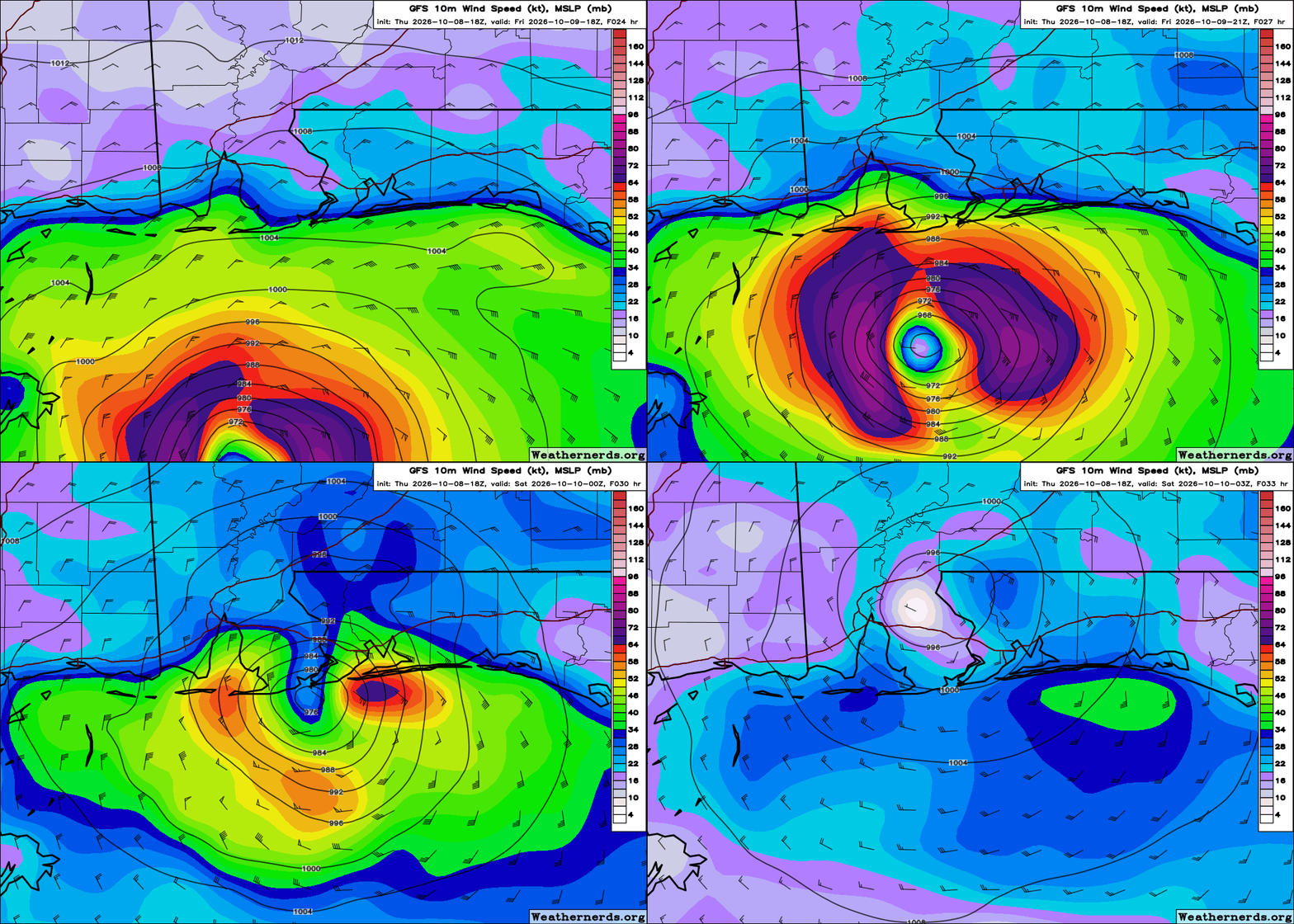
You can see how the hurricane force winds (dark purple colors) rapidly decrease in the last 6 hours before landfall.
Let's hope that is the case.
Posted on 10/8/26 at 5:41 pm to MasterDigger
Google Deep Mind 3 and all their other AI models are showing a Destin area landfall. We won't have to wait much longer to find out who's right.
Posted on 10/8/26 at 5:42 pm to baldona
quote:
If I'm understanding this right, the conditions are almost right enough for it to intensify but every time it tries to it ends up failing. So it has not really intensified yet? Hopefully it continues to not intensify?
Pretty much, but it has gradually strengthened throughout the day despite the shear. The shear has kept it from really wrapping around that inner core which it needs to do to take off and bomb out. It has more or less followed the intensity forecast to this point.
The shear doesn't go away, it is just a matter of how well it can handle it.
Posted on 10/8/26 at 5:42 pm to AHM21
quote:my take as well
It’ll be a weak hurricane but any intensification that occurs the next 24 hours will be cut off before it comes ashore. Then it weakens rapidly as it moves inland.
Posted on 10/8/26 at 5:43 pm to AU_251
quote:
Don’t say that :(
Opal was a Cat 4 monster, I don’t think we quite get there hopefully but the track is shifting into that range.

 Page 106 of 151



Popular

Back to top
 Follow TigerDroppings for LSU Football News