- My Forums
- Tiger Rant
- LSU Recruiting
- SEC Rant
- Saints Talk
- Pelicans Talk
- More Sports Board
- Coaching Changes
- Fantasy Sports
- Golf Board
- Soccer Board
- O-T Lounge
- Tech Board
- Home/Garden Board
- Outdoor Board
- Health/Fitness Board
- Movie/TV Board
- Book Board
- Music Board
- Political Talk
- Money Talk
- Fark Board
- Gaming Board
- Travel Board
- Food/Drink Board
- Ticket Exchange
- TD Help Board
Customize My Forums- View All Forums
- Show Left Links
- Topic Sort Options
- Trending Topics
- Recent Topics
- Active Topics
Started By
Message

 0
0

Posted on 8/31/17 at 6:45 am to rds dc
Watch the SW turn, climo for storms that make that turn is a bit concerning. Last two Euro EPS runs:
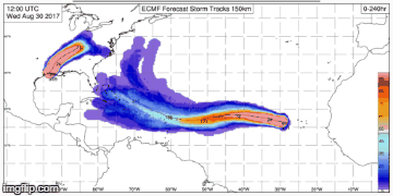
This post was edited on 8/31/17 at 6:47 am

Posted on 8/31/17 at 7:34 am to rt3
Not necessarily there's been plenty of storms that have survived Cuba fine depending on their strength. Plus the gulf is a powder keg at the moment so once it gets in it would be able to regain its strength quickly.
Posted on 8/31/17 at 7:37 am to rds dc
Umm, I don't like that at all
Posted on 8/31/17 at 8:19 am to GEAUXT
quote:
Michael Ventrice @MJVentrice
Major development: The best ECMWF EPS members via initialization score are west of ensemble mean track, taking #Irma into the Gulf of Mexico
Posted on 8/31/17 at 8:21 am to rds dc
GEFS not buying it

This post was edited on 8/31/17 at 9:51 pm

Posted on 8/31/17 at 8:23 am to rds dc
frick this euro

Posted on 8/31/17 at 8:24 am to rds dc
isnt Euro better when its in the water then GEFS is good once it hits US mainland?
Posted on 8/31/17 at 8:44 am to tke857
quote:
isnt Euro better when its in the water then GEFS is good once it hits US mainland?
We are talking beyond D10 for something to get in the Gulf. The operational models show little skill at that point. The ensembles are somewhat useful but are still prone to totally flipping on things at that range. The Euro EPS has more members and is more dispersive than the GEFS, so on any random run it is more likely to get members in the Gulf in the long range.
The 00z super ensemble mean is still east of the US. However, the EPS trend is concerning as it lights up the eastern Gulf.
Posted on 8/31/17 at 9:05 am to rds dc
What's been the trend for gefs? Holding steady?

Posted on 8/31/17 at 9:19 am to rds dc
New York couldn't handle a storm that strong
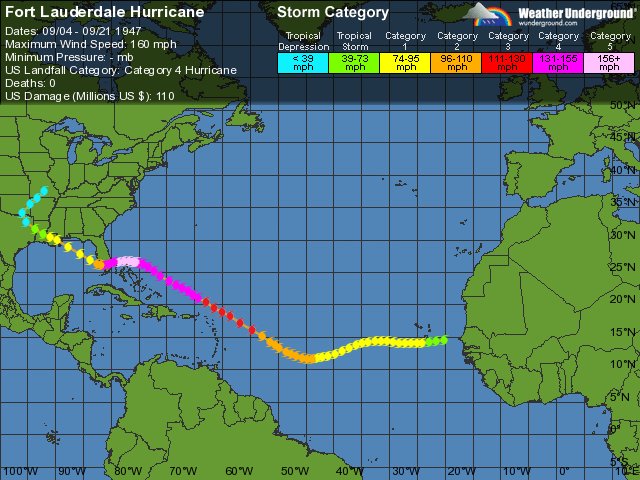
Posted on 8/31/17 at 9:37 am to BayouBengals03
quote:
Eric Webb? @webberweather
Wrt location/intensity where #Irma's unusual WSW movement is occurring, it bears a lot of similarities to the 1947 Ft. Lauderdale Hurricane
Posted on 8/31/17 at 9:40 am to Jim Rockford
quote:
man get this shite out of here
Posted on 8/31/17 at 9:49 am to tke857

Posted on 8/31/17 at 9:56 am to Jim Rockford
quote:
Wrt location/intensity where #Irma's unusual WSW movement is occurring, it bears a lot of similarities to the 1947 Ft. Lauderdale Hurricane
These tweets are just unnecessary hype. Taking a southwesterly turn 3000 miles from the US doesn't mean a damn thing about what it will do in a week.
Posted on 8/31/17 at 9:56 am to Pedro
quote:
What's been the trend for gefs? Holding steady?
For the most part. It is showing a northward motion bias in the short range. However, pretty much all models are in the short term with this system. Big key, how much lat does it gain in the next 24hrs before bending back SW.
Posted on 8/31/17 at 9:57 am to slackster
Cat 4 or Cat 5 could be in play....good god
This post was edited on 8/31/17 at 9:58 am

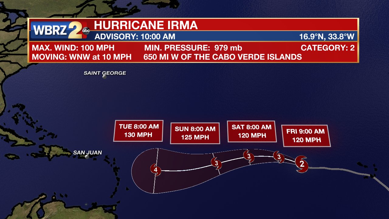
Posted on 8/31/17 at 9:57 am to rds dc
Steve Caparotta?Verified account @SteveWAFB 7m7 minutes ago
More
BREAKING: #Irma has rapidly intensified into a Cat. 2 #hurricane & forecast to be a Cat. 4 approaching the Caribbean.
More
BREAKING: #Irma has rapidly intensified into a Cat. 2 #hurricane & forecast to be a Cat. 4 approaching the Caribbean.
Posted on 8/31/17 at 9:58 am to tke857
It is now Hurricane Irma:
quote:
1100 AM AST Thu Aug 31 2017
...HURRICANE IRMA RAPIDLY INTENSIFYING OVER THE EASTERN ATLANTIC...
SUMMARY OF 1100 AM AST...1500 UTC...INFORMATION
-----------------------------------------------
LOCATION...16.9N 33.8W
ABOUT 650 MI...1050 KM W OF THE CABO VERDE ISLANDS
ABOUT 1845 MI...2975 KM E OF THE LEEWARD ISLANDS
MAXIMUM SUSTAINED WINDS...100 MPH...155 KM/H
PRESENT MOVEMENT...WNW OR 290 DEGREES AT 10 MPH...17 KM/H
MINIMUM CENTRAL PRESSURE...979 MB...28.91 INCHES
WATCHES AND WARNINGS
--------------------
There are no coastal watches or warnings in effect.
DISCUSSION AND 48-HOUR OUTLOOK
------------------------------
At 1100 AM AST (1500 UTC), the center of Hurricane Irma was located
near latitude 16.9 North, longitude 33.8 West. Irma is moving toward
the west-northwest near 10 mph (17 km/h). This general motion is
forecast through early Friday, followed by a generally westward
motion on Saturday.
Maximum sustained winds have increased to near 100 mph (155 km/h)
with higher gusts. Irma is forecast to become a major hurricane by
tonight and is expected to be an extremely dangerous hurricane for
the next several days.
Hurricane-force winds extend outward up to 15 miles (30 km) from the
center and tropical-storm-force winds extend outward up to 80 miles
(130 km).
The estimated minimum central pressure is 979 mb (28.91 inches).

Posted on 8/31/17 at 9:59 am to tke857
Has to be scary as hell to be stuck in the Lesser Antilles during one of these storms.

 Page 6 of 711

Popular
Back to top