- My Forums
- Tiger Rant
- LSU Recruiting
- SEC Rant
- Saints Talk
- Pelicans Talk
- More Sports Board
- Fantasy Sports
- Golf Board
- Soccer Board
- O-T Lounge
- Tech Board
- Home/Garden Board
- Outdoor Board
- Health/Fitness Board
- Movie/TV Board
- Book Board
- Music Board
- Political Talk
- Money Talk
- Fark Board
- Gaming Board
- Travel Board
- Food/Drink Board
- Ticket Exchange
- TD Help Board
Customize My Forums- View All Forums
- Show Left Links
- Topic Sort Options
- Trending Topics
- Recent Topics
- Active Topics
Started By
Message
re: Hurricane Florence - Catastrophic Flooding Potential
Posted on 9/3/18 at 12:55 pm to deuce985
Posted on 9/3/18 at 12:55 pm to deuce985
quote:
Anyone post the doomsday HMON yet?
What did that thing do to Irma last year? I think it had it at a 890mb pressure hurricane. Irma was beastly but goddamn.
It was way lower like 857mb or something ridiculous like that
 2
2


Posted on 9/3/18 at 12:57 pm to deltaland
The latest radar has me a little concerned.

Posted on 9/3/18 at 12:57 pm to corym52
quote:
I guess the potential for rapid intensification is there now?
From Stormcast board
“I think the only thing hampering him from rapid intensification right now is the upper level low to the southwest. Other than that, I expect intensification all the way up to landfall.”
Posted on 9/3/18 at 12:58 pm to theOG
quote:
The JW Marriott on Marco Island has webcams, so you can check it out.
Checking it out now, i thought i saw a line out there for people waiting to reserve Palapas for 2morrow

Posted on 9/3/18 at 12:58 pm to urinetrouble
Posted on 9/3/18 at 12:59 pm to urinetrouble
Looks like recon may have found a sub 1000mb reading. I assume the 2pm update from NHC was released before the recon that was running. I think it is safe to say they are a bit behind Gordon.
This post was edited on 9/3/18 at 1:00 pm
Posted on 9/3/18 at 12:59 pm to deltaland
Already up to 50 mph on next advisory
Posted on 9/3/18 at 12:59 pm to BigB0882
Levi Cowan
?
@TropicalTidbits
Following Following @TropicalTidbits
More
It's hard to perfectly sample a core this small, but the plane found a pressure at least 6mb lower than 3 hours ago, and probably a little lower than that in reality. Confirmation that #Gordon is intensifying quickly at this moment.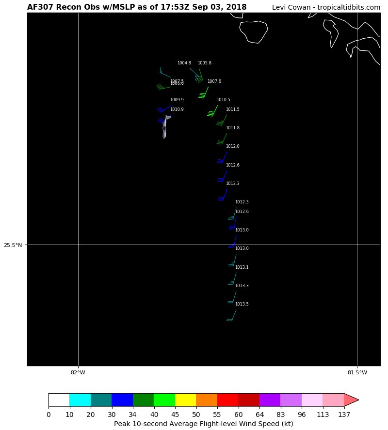
?
@TropicalTidbits
Following Following @TropicalTidbits
More
It's hard to perfectly sample a core this small, but the plane found a pressure at least 6mb lower than 3 hours ago, and probably a little lower than that in reality. Confirmation that #Gordon is intensifying quickly at this moment.

Posted on 9/3/18 at 12:59 pm to BigB0882
Grand Isle doing a voluntary evacuation

Posted on 9/3/18 at 1:00 pm to lsuman25
Admins y u no sticky thread?
Posted on 9/3/18 at 1:02 pm to When in Rome
70 mph winds by tom 7pm according to latest, but seems like it's going to strengthen faster than that?
Posted on 9/3/18 at 1:02 pm to tLSU
48

Posted on 9/3/18 at 1:03 pm to When in Rome
Looking at the NWS radar out of Miami, the last very frames show it heading a bit west and shows a eye.
Posted on 9/3/18 at 1:04 pm to fishfighter
What is the wind field looking like?
Posted on 9/3/18 at 1:04 pm to tLSU
East of last run, might be east of all the other majors now. UKmet, Canadian, and GFS had Louisiana landfall. Leads me to start leaning into a Hancock County type solution.
Posted on 9/3/18 at 1:05 pm to tLSU
It seems final landfall on Euro didn't budge by much.
This post was edited on 9/3/18 at 1:05 pm
Posted on 9/3/18 at 1:06 pm to Duke
When would the northshore start feeling effects of the storm, if it continues on the expected path?

Posted on 9/3/18 at 1:08 pm to When in Rome
So I guess I should plan on going to work in Lafayette on Wednesday?
This post was edited on 9/3/18 at 1:08 pm
Posted on 9/3/18 at 1:09 pm to When in Rome
quote:
When would the northshore start feeling effects of the storm, if it continues on the expected path?
Are you incapable of reading and interpreting an arrival time map that is posted on the first page and is updated as it becomes available?
Posted on 9/3/18 at 1:09 pm to When in Rome
Tuesday night into Wednesday. Thinking would be, taking the Euro path and/or NHC path that the farther east and north in the Northshore would yield bigger wind impacts.

 Page 32 of 400

Popular
Back to top