- My Forums
- Tiger Rant
- LSU Recruiting
- SEC Rant
- Saints Talk
- Pelicans Talk
- More Sports Board
- Fantasy Sports
- Golf Board
- Soccer Board
- O-T Lounge
- Tech Board
- Home/Garden Board
- Outdoor Board
- Health/Fitness Board
- Movie/TV Board
- Book Board
- Music Board
- Political Talk
- Money Talk
- Fark Board
- Gaming Board
- Travel Board
- Food/Drink Board
- Ticket Exchange
- TD Help Board
Customize My Forums- View All Forums
- Show Left Links
- Topic Sort Options
- Trending Topics
- Recent Topics
- Active Topics
Started By
Message
re: Hurricane Florence - Catastrophic Flooding Potential
Posted on 9/12/18 at 11:52 am to TigerDude80

Posted on 9/12/18 at 11:52 am to TigerDude80
quote:
WTF is the disturbance behind Florence???
Tropical flatulence. Florence is a nasty lady.
 0
0

Posted on 9/12/18 at 11:53 am to TigerDude80
Isaac slams right into panhandle


Posted on 9/12/18 at 11:55 am to deuce985
How much of isaac will be left after it gets Guantanamo Bay prison raped?
Posted on 9/12/18 at 11:56 am to deuce985
quote:
Isaac slams right into panhandle
pressures getting 980-970... that's hurricane strength, no?
Posted on 9/12/18 at 11:58 am to S
That forecast shows it not getting sheared like the other models are showing and it eventually finds a weakness to turn north.
Thing to watch would be if other models are agreeing with less shear and a more northward forecast over next few days. Right now it's fantasy land forecast.
Thing to watch would be if other models are agreeing with less shear and a more northward forecast over next few days. Right now it's fantasy land forecast.
Posted on 9/12/18 at 11:59 am to deuce985

Huh. A little north of the track currently. Recon pass upcoming will get a proper fix at least.

Posted on 9/12/18 at 12:00 pm to Duke

Posted on 9/12/18 at 12:01 pm to tgrbaitn08
quote:
the hurricane hunter trying to send us a message


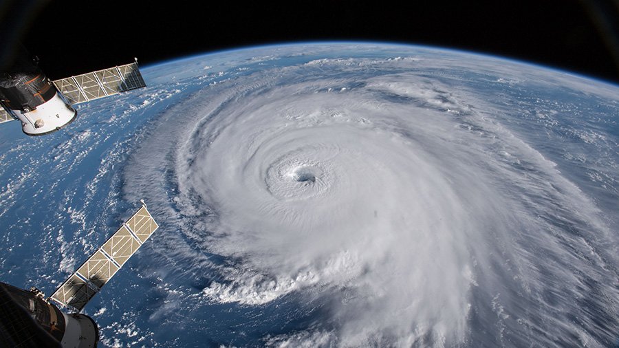
Posted on 9/12/18 at 12:01 pm to GetCocky11
That is a awesome picture 
Posted on 9/12/18 at 12:02 pm to rt3
Yup potential Cat 1.
Posted on 9/12/18 at 12:02 pm to Duke
quote:
Huh. A little north of the track currently. Recon pass upcoming will get a proper fix at least.
there should be a 4th drop in the eye on the current HH mission
but between drops 1 & 3 (~ 3 1/2 hrs between)... it's moved 0.5 N, 0.8 W
Posted on 9/12/18 at 12:03 pm to GetCocky11
Looks like you can dive right in it

Posted on 9/12/18 at 12:03 pm to When in Rome
quote:
Do you have a generator? Can your house sustain the projected winds?
Got a generator, house has hurricane clips, windows are hurricane glass. No pine trees near my house, just some oaks in the neighbor's yard.
Posted on 9/12/18 at 12:03 pm to deuce985
quote:
Looks like GFS has Isaac gaining strength in caribbean, turns northwest and drifts into the gulf. Kinda interesting it's doing that. Others showed a lot of shear then a ridge that parks over the top preventing it turning north. I'll be curious to see what GFS does with it when this run is over.
The ensembles have been picking up on the possibility of Isaac bouncing back to life in the Caribbean. There are some signs of conditions improving but still too far out to try and tease any details, esp. with the ongoing uncertainty associated with what happens to Florence.
00z Euro EPS

Posted on 9/12/18 at 12:07 pm to MountainTiger
quote:
I also remember the tracking maps they'd print in the newspaper. You'd cut it out, stick it to the refrigerator and if a storm was coming in, you'd get the latest position every day and mark a little dot on the map.
The release of the "hurricane tracking map" was a big thing in my household, growing up. Each tv station would link up with a business to distribute them. So maybe WWL's would be available at Wendy's, etc.
Posted on 9/12/18 at 12:07 pm to wickowick
quote:
for anyone in a mandatory evac area, most homeowner's insurances cover up to 2 weeks of cost. SAVE ALL RECEIPTS
Hopefully but I doubt they ever do it. I had a wreck on the coast once and no rental cars available. Truck could be fixed to drive but would take a day or two. Insurance said get a hotel and they’d cover the cost and all food during repair time.
Never saw that money. frickers
Posted on 9/12/18 at 12:08 pm to Duke
Myrtle Beach is forecast to get it on the chin.
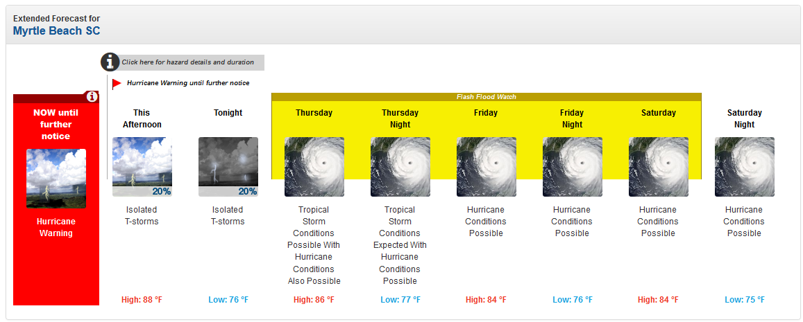
weather.gov

Yikes.
Also look at that outflow on all but the SW side.

weather.gov
Yikes.
Also look at that outflow on all but the SW side.
This post was edited on 9/12/18 at 12:11 pm
Posted on 9/12/18 at 12:11 pm to LSU Patrick
quote:
I'd put 100 bucks on TABS.
TABS can go frick itself.
Posted on 9/12/18 at 12:11 pm to rds dc
Why does every single storm have at least one model that takes the storm right up New Orleans arse?
Posted on 9/12/18 at 12:12 pm to Purple Spoon
quote:
Why does every single storm have at least one model that takes the storm right up New Orleans arse?
that's the 'frick Mitch' model

 Page 238 of 400

Popular
Back to top