- My Forums
- Tiger Rant
- LSU Recruiting
- SEC Rant
- Saints Talk
- Pelicans Talk
- More Sports Board
- Fantasy Sports
- Golf Board
- Soccer Board
- O-T Lounge
- Tech Board
- Home/Garden Board
- Outdoor Board
- Health/Fitness Board
- Movie/TV Board
- Book Board
- Music Board
- Political Talk
- Money Talk
- Fark Board
- Gaming Board
- Travel Board
- Food/Drink Board
- Ticket Exchange
- TD Help Board
Customize My Forums- View All Forums
- Show Left Links
- Topic Sort Options
- Trending Topics
- Recent Topics
- Active Topics
Started By
Message
 5
5

Posted on 9/9/18 at 9:42 pm to Golfer
TAKe tons of pics of house and belongings
Posted on 9/9/18 at 9:44 pm to Golfer
quote:
have friends that live in Wilmington and have never dealt with a hurricane. Told them to gtfo on Wednesday morning and make sure that car had gas in it tomorrow.
A major problem with many in the carolinas is that we havn't had a real zinger in a long time. They probably think Matthew was the real deal.
Since the last one we've also had of course many become adults and a ton of northerners move down here and do not know that they really do need to take this stuff seriously.
This post was edited on 9/9/18 at 9:47 pm

Posted on 9/9/18 at 9:44 pm to Dlab2013
quote:.
I just like to be within a few hours of where the most damage is so I can hit the ground running once roads start opening up and flood waters recede. Looking at the map, I was actually thinking Asheville, looks to be the same area. Thanks
Columbia is closer to Wilmington.
This post was edited on 9/9/18 at 9:45 pm
Posted on 9/9/18 at 9:44 pm to Dlab2013
Unless it moves back south, I’d just head to Charlotte.

Posted on 9/9/18 at 9:45 pm to Dlab2013
quote:
I’m a flood adjuster and I’m trying to plan ahead.....The uncertainty of the whole thing has me hesitant, but Knoxville TN should be a good/safe staging area untill the aftermath correct? Thinking about heading that way Sunday.
I am gathering my gear together to head out also. Wind side.
Posted on 9/9/18 at 9:46 pm to AubieALUMdvm
quote:
A major problem with many in the carolinas is that we havn't had a real zinger in a long time. Since the last one we've also had of course many become adults and a ton of northerners move down here and do not know that they really do need to take this stuff seriously.
i hope they get educated quick. If this thing pops to a 4 soon. you could have Katrina like surges, even, as we saw with Katrina, if the wind speed drops just before landfall. This thing looks like it will have a large wind field as well.
Posted on 9/9/18 at 9:48 pm to rds dc
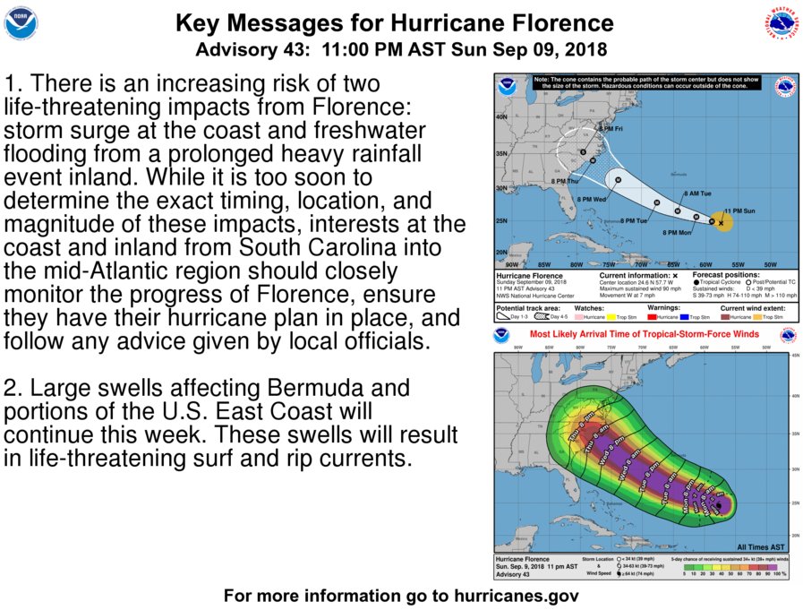
Deep convection continues to fire in the WCAB. There was a mid level vort earlier today but nothing in the lower levels. CIMSS analysis now shows the 700mb vort increasing this evening. If convection continues to fire overnight then the vort could mix down to the surface. Wouldn't be surprised to see NHC to bump this up from 30% later tonight.


Posted on 9/9/18 at 9:49 pm to rds dc

Posted on 9/9/18 at 9:50 pm to GetCocky11
quote:
Columbia is closer to Wilmington.
Columbia might be too close for comfort depending on where it actually hits. Thinking about heading in that direction from Louisiana early Sunday morning.
Posted on 9/9/18 at 9:50 pm to GetCocky11
quote:
Columbia is closer to Wilmington.
Good point. Only 3 hours under normal conditions
Posted on 9/9/18 at 9:53 pm to Duke
quote:
Eye looks like it's about ready to peak out.
There it is.

Posted on 9/9/18 at 10:00 pm to Duke
quote:
Eye looks like it's about ready to peak out.
Starting to really show up on the 1-min scans, really deep convection firing all around the center.


Posted on 9/9/18 at 10:04 pm to slackster
Wondering how well the Carolina beaches fared with major hurricanes in the past?
Here is a photo of Garden City Beach, SC (near Myrtle Beach) after Hugo wrecked it in 1989 with a 14 foot storm surge.
FTR, Hugo's eyewall came ashore 50 miles away.

Here is a photo of Garden City Beach, SC (near Myrtle Beach) after Hugo wrecked it in 1989 with a 14 foot storm surge.
FTR, Hugo's eyewall came ashore 50 miles away.
Posted on 9/9/18 at 10:05 pm to AubieALUMdvm
Just a aide note, but while reading about massive rain totals, I can across an article talking about TC Gamede in 2007. It set the world record rainfall totals for 72 and 96 hours.
As the storm progressed, these were the totals.
24 hrs - 64"
48 hrs - 97"
72 hrs - 154"
96 hrs - 191"
Those are totals I can't even fathom. 5 feet of rain in one day, 8 feet over two days, nearly 13 feet over 3 days and almost 16 feet over 4 days. I mean, how in the hell?
As the storm progressed, these were the totals.
24 hrs - 64"
48 hrs - 97"
72 hrs - 154"
96 hrs - 191"
Those are totals I can't even fathom. 5 feet of rain in one day, 8 feet over two days, nearly 13 feet over 3 days and almost 16 feet over 4 days. I mean, how in the hell?
This post was edited on 9/9/18 at 10:27 pm
Posted on 9/9/18 at 10:05 pm to rds dc
I don't remember in the past a serious warning like this 4 days in advance
Posted on 9/9/18 at 10:06 pm to rds dc
quote:
Starting to really show up on the 1-min scans, really deep convection firing all around the center.
It's about to be closed off completely and then who knows where the intensification stops.
Posted on 9/9/18 at 10:08 pm to AubieALUMdvm
quote:
Since the last one we've also had of course many become adults and a ton of northerners move down here and do not know that they really do need to take this stuff seriously.
I just laid it on them hard. That storm surge isn’t a joke and as the crow flies they have water (Atlantic and Cape Fear River)within 1/2 mile on the east and the west side of them.
Posted on 9/9/18 at 10:08 pm to slackster
(no message)
This post was edited on 9/9/18 at 10:10 pm

 Page 125 of 400

Popular
Back to top