- My Forums
- Tiger Rant
- LSU Recruiting
- SEC Rant
- Saints Talk
- Pelicans Talk
- More Sports Board
- Fantasy Sports
- Golf Board
- Soccer Board
- O-T Lounge
- Tech Board
- Home/Garden Board
- Outdoor Board
- Health/Fitness Board
- Movie/TV Board
- Book Board
- Music Board
- Political Talk
- Money Talk
- Fark Board
- Gaming Board
- Travel Board
- Food/Drink Board
- Ticket Exchange
- TD Help Board
Customize My Forums- View All Forums
- Show Left Links
- Topic Sort Options
- Trending Topics
- Recent Topics
- Active Topics
Started By
Message
 0
0


Posted on 9/9/18 at 10:10 pm to Golfer
what are the storm surge estimates?
Posted on 9/9/18 at 10:13 pm to Golfer
quote:
That storm surge isn’t a joke and as the crow flies they have water (Atlantic and Cape Fear River)within 1/2 mile on the east and the west side of them.
They'll certainly have a mandatory evacuation order to back up the danger here. I'd be out by Tuesday morning, hopefully to get a little ahead of traffic.
Posted on 9/9/18 at 10:13 pm to LaBR4
quote:
what are the storm surge estimates?
Those won't start showing up with the NHC for another day or two.

Posted on 9/9/18 at 10:15 pm to slackster
quote:
almost 46 feet over 4 days
Your math is off or you hit the wrong button...

Posted on 9/9/18 at 10:15 pm to LaBR4
Posted on 9/9/18 at 10:16 pm to slackster

Jeff is going to have a field day with this one
This post was edited on 9/9/18 at 10:39 pm
Posted on 9/9/18 at 10:20 pm to Golfer
quote:
I have friends that live in Wilmington and have never dealt with a hurricane. Told them to gtfo on Wednesday morning and make sure that car had gas in it tomorrow.
with tropical storm force winds expected to arrive late Wednesday (just watched the Sunday hit by Levi at Tropical Tidbits)... I'd be planning to get out of there around midday Tuesday... if not sooner
I'd esp be concerned with traffic... I'd try to beat that traffic
Posted on 9/9/18 at 10:21 pm to rt3
quote:
I'd esp be concerned with traffic... I'd try to beat that traffic
I would pick up tomorrow and leave tomorrow night.

Posted on 9/9/18 at 10:23 pm to LaBR4
Kylie can ride out the storm with me. 
Posted on 9/9/18 at 10:24 pm to Fratigerguy
quote:
Your math is off or you hit the wrong button...
Posted on 9/9/18 at 10:24 pm to East Coast Band
quote:
Wondering how well the Carolina beaches fared with major hurricanes in the past
Let’s be real, no barrier island beach house anywhere can deal with 14’ storm surge, period. Even stilts/pilings will only protect to 8-10’ and that doesn’t include wave action on top of the actual surge.
That is a total loss situation with a strong likelihood of the roads, sewers and electric being offline for months before you can even begin rebuilding.
There are hardly even dunes on many of these islands like Topsail and the Wilmington Beaches (Kure, Carolina, etc) which in many places are only one or two rows wide.
If this happens with that type of surge even setting aside wind or rain, everything that isn’t a high rise condo is getting bulldozed assuming it’s still on its foundations at all.
This post was edited on 9/9/18 at 10:26 pm
Posted on 9/9/18 at 10:26 pm to LaBR4
quote:
Jeff is going to have field day with this one
Idk if "Boom" is the best way to describe a hurricane projection hitting the US, but yeah, Jeff will be over the top as always
Posted on 9/9/18 at 10:27 pm to wickowick
when my family & I "evacuated" for Katrina (I put evacuated in quotes b/c we went from NOLA to Picayune, MS as I stated earlier)... we went on Saturday morning... the storm hit on a Tuesday
the traffic jam was all day Sunday
ETA: we knew we had to leave early b/c we knew the way we were going would be shut down for contraflow... had to get there before everything was reversed
the traffic jam was all day Sunday
ETA: we knew we had to leave early b/c we knew the way we were going would be shut down for contraflow... had to get there before everything was reversed
This post was edited on 9/9/18 at 10:30 pm
Posted on 9/9/18 at 10:28 pm to slackster
quote:
Idk if "Boom" is the best way to describe a hurricane projection hitting the US, but yeah, Jeff will be over the top as always
yeah... I thought the "boom" was in poor taste
Posted on 9/9/18 at 10:29 pm to tide06
Bridges are going to be damaged and or destroyed. Access to the islands will be really hard for a long time.
Posted on 9/9/18 at 10:29 pm to wickowick
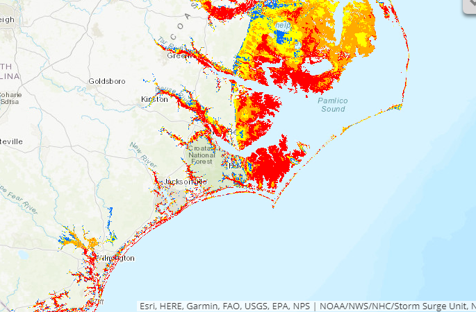
quote:
Storm Surge Maps
Those are just generic maps, but a good place to start nonetheless.
The NHC has experimental predictions they issue once the storm gets closer. They're storm specific.
Posted on 9/9/18 at 10:32 pm to slackster
quote:
The NHC has experimental predictions
I was directed to that site from the NHC, but you are correct, they are general maps.
Posted on 9/9/18 at 10:35 pm to slackster
Another thing to consider is that eastern NC has had one of it’s wettest summers on record.
This means the soil is thoroughly inundated from Greensboro to the coast, which combined with our usual poor draining clay could lead to flooding with any kind of prolonged or heavy rain, much less a hurricane of this magnitude.
Even two hours west here in Raleigh/Durham/Chapel Hill could be dealing with floods and massive numbers of trees down due to soggy soil and high winds.
This post was edited on 9/9/18 at 10:49 pm
Posted on 9/9/18 at 10:35 pm to Duke
quote:”Peek” out??
Eye looks like it's about ready to peak out.
Or, peak out as in “max out”?

 Page 126 of 400

Popular
Back to top