




 1
1










- My Forums
- Tiger Rant
- LSU Recruiting
- SEC Rant
- Saints Talk
- Pelicans Talk
- More Sports Board
- Fantasy Sports
- Golf Board
- Soccer Board
- O-T Lounge
- Tech Board
- Home/Garden Board
- Outdoor Board
- Health/Fitness Board
- Movie/TV Board
- Book Board
- Music Board
- Political Talk
- Money Talk
- Fark Board
- Gaming Board
- Travel Board
- Food/Drink Board
- Ticket Exchange
- TD Help Board
Customize My Forums- View All Forums
- Show Left Links
- Topic Sort Options
- Trending Topics
- Recent Topics
- Active Topics
Started By
Message
re: Helene - Recovery Begins...Devastating Flash Flooding in Western NC and Eastern TN
Posted on 9/26/24 at 10:19 pm to Riseupfromtherubble
Posted on 9/26/24 at 10:19 pm to Riseupfromtherubble
Perry FL had a recorded Wind Gust of 99 mph
Prolly more
Prolly more
Posted on 9/26/24 at 10:19 pm to LanierSpots
Also did he leave??
Posted on 9/26/24 at 10:19 pm to LanierSpots
We have official landfall:
Hurricane Helene Tropical Cyclone Update
NWS National Hurricane Center Miami FL AL092024
1120 PM EDT Thu Sep 26 2024
...HELENE MAKES LANDFALL IN THE FLORIDA BIG BEND...
Based on NWS Doppler radar data, the eye of Helene has made landfall
as a Category 4 hurricane in the Florida Big Bend region at about
11:10 PM EDT (0310 UTC) just east of the mouth of the Aucilla
River. This is about 10 miles (15 km) west-southwest of Perry,
Florida. Based on data from Air Force reconnaissance aircraft, the
maximum sustained winds are estimated to be 140 mph (225 km/h) and
the minimum central pressure is 938 mb (27.70 inches).
SUMMARY OF 1110 PM EDT...0310 UTC...INFORMATION
----------------------------------------------
LOCATION...30.0N 83.7W
ABOUT 70 MI...115 KM NNW OF CEDAR KEY FLORIDA
ABOUT 45 MI...70 KM ESE OF TALLAHASSEE FLORIDA
MAXIMUM SUSTAINED WINDS...140 MPH...225 KM/H
PRESENT MOVEMENT...NNE OR 20 DEGREES AT 24 MPH...39 KM/H
MINIMUM CENTRAL PRESSURE...938 MB...27.70 INCHES
Hurricane Helene Tropical Cyclone Update
NWS National Hurricane Center Miami FL AL092024
1120 PM EDT Thu Sep 26 2024
...HELENE MAKES LANDFALL IN THE FLORIDA BIG BEND...
Based on NWS Doppler radar data, the eye of Helene has made landfall
as a Category 4 hurricane in the Florida Big Bend region at about
11:10 PM EDT (0310 UTC) just east of the mouth of the Aucilla
River. This is about 10 miles (15 km) west-southwest of Perry,
Florida. Based on data from Air Force reconnaissance aircraft, the
maximum sustained winds are estimated to be 140 mph (225 km/h) and
the minimum central pressure is 938 mb (27.70 inches).
SUMMARY OF 1110 PM EDT...0310 UTC...INFORMATION
----------------------------------------------
LOCATION...30.0N 83.7W
ABOUT 70 MI...115 KM NNW OF CEDAR KEY FLORIDA
ABOUT 45 MI...70 KM ESE OF TALLAHASSEE FLORIDA
MAXIMUM SUSTAINED WINDS...140 MPH...225 KM/H
PRESENT MOVEMENT...NNE OR 20 DEGREES AT 24 MPH...39 KM/H
MINIMUM CENTRAL PRESSURE...938 MB...27.70 INCHES
This post was edited on 9/26/24 at 10:22 pm
Posted on 9/26/24 at 10:19 pm to tiger91
quote:
That sucks. How are you and your business?
All good. Not bad at all here. My shop seems fine too. I checked the camera and I still have power and internet there. Got lucky. Just a few miles away got some good surge.
My home is far enough away from the coast not to be a issue. When I moved here, I was scared of the coast.

I can get to the beach in 15 mins and thats close enough.
Posted on 9/26/24 at 10:20 pm to Delacroix22
Same here remember it well in Woodstock
Posted on 9/26/24 at 10:20 pm to The Boat
quote:
Then you have to have instruments in the right place to measure the strongest winds.
WE NEED MORE AND BETTER STATIONS.
I say it every time.
This post was edited on 9/26/24 at 10:21 pm
Posted on 9/26/24 at 10:20 pm to tiger91
quote:
Also did he leave??
Nope
Posted on 9/26/24 at 10:21 pm to Pettifogger
quote:
anemometers break
Surely we have the technological capability now to build anemometers that can sustain incredibly high wind if desired.
Posted on 9/26/24 at 10:21 pm to The Boat
Gust may approach 140.....
But there is generally a 2/3 rule on Sustained
Maybe 85-90 sustained
But there is generally a 2/3 rule on Sustained
Maybe 85-90 sustained
Posted on 9/26/24 at 10:21 pm to The Boat
Posted on 9/26/24 at 10:21 pm to LegendInMyMind
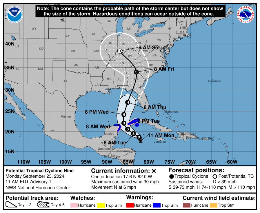
Initial cone:

Posted on 9/26/24 at 10:21 pm to LegendInMyMind
quote:
WE NEED MORE AND BETTER STATIONS.
I say every time.
If I ever get Chicken to wipe my TD account and run for Congress this will be my priority.
Posted on 9/26/24 at 10:21 pm to Hobie101
For the Georgia folks ...NHC updated the track with the 11:00 advisory.
Comes up just west of Macon, heading pretty much due north, crosses right over Jackson, Conyers, and Snellville, takes a slight NW turn and skirts Lawrenceville on the west side.and heads toward Canton and Cleveland, TN.
Comes up just west of Macon, heading pretty much due north, crosses right over Jackson, Conyers, and Snellville, takes a slight NW turn and skirts Lawrenceville on the west side.and heads toward Canton and Cleveland, TN.
This post was edited on 9/26/24 at 10:23 pm
Posted on 9/26/24 at 10:22 pm to LanierSpots
Glad to hear it. No hope Florida gets a break the next few years. I hope that we all do.
Posted on 9/26/24 at 10:22 pm to ApexHunterNetcode
quote:
Surely we have the technological capability now to build anemometers that can sustain incredibly high wind if desired.
We do. The Japanese have them, but we can't even keep what we have functional, so......
Posted on 9/26/24 at 10:22 pm to tiger91
Posted on 9/26/24 at 10:22 pm to LanierSpots
Is he regretting that decision??
Posted on 9/26/24 at 10:23 pm to LanierSpots
quote:
LanierSpots
You all good man?? Our power went out for about 4 hours or so, but it's back on now. Not much rain, but the wind was whipping there for a while.
Posted on 9/26/24 at 10:24 pm to PJinAtl
Power just went out here in Neptune Beach (Jacksonville coast)
This post was edited on 9/26/24 at 10:28 pm

 Page 216 of 310



Popular

Back to top
 Follow TigerDroppings for LSU Football News