- My Forums
- Tiger Rant
- LSU Recruiting
- SEC Rant
- Saints Talk
- Pelicans Talk
- More Sports Board
- Fantasy Sports
- Golf Board
- Soccer Board
- O-T Lounge
- Tech Board
- Home/Garden Board
- Outdoor Board
- Health/Fitness Board
- Movie/TV Board
- Book Board
- Music Board
- Political Talk
- Money Talk
- Fark Board
- Gaming Board
- Travel Board
- Food/Drink Board
- Ticket Exchange
- TD Help Board
Customize My Forums- View All Forums
- Show Left Links
- Topic Sort Options
- Trending Topics
- Recent Topics
- Active Topics
Started By
Message
 0
0

Posted on 8/24/17 at 3:59 pm to rt3
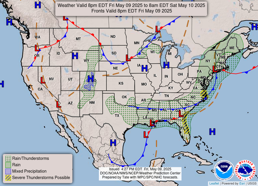
I still can't fathom AT LEAST a tropical storm sitting over Corpus for THREE FULL DAYS.
Posted on 8/24/17 at 4:00 pm to slackster
quote:
NHC forecasted wind probabilities suggest Rockport, TX is the most at risk location at the moment. 71% chance of wind speeds 74mph or greater over the next few days. That's the highest city listed in their forecast.
can you post that table or a link
thx
Posted on 8/24/17 at 4:00 pm to OldSouth
quote:
I still can't fathom AT LEAST a tropical storm sitting over Corpus for THREE FULL DAYS.
if it stalls just at or offshore it will be devastating. no land to kill the power.
Posted on 8/24/17 at 4:01 pm to rt3
quote:
negative... don't think the previous cone covered any of Louisiana
Either way this is potentially worse than before.

Posted on 8/24/17 at 4:01 pm to OchoDedos
frick this noise
Posted on 8/24/17 at 4:02 pm to rt3
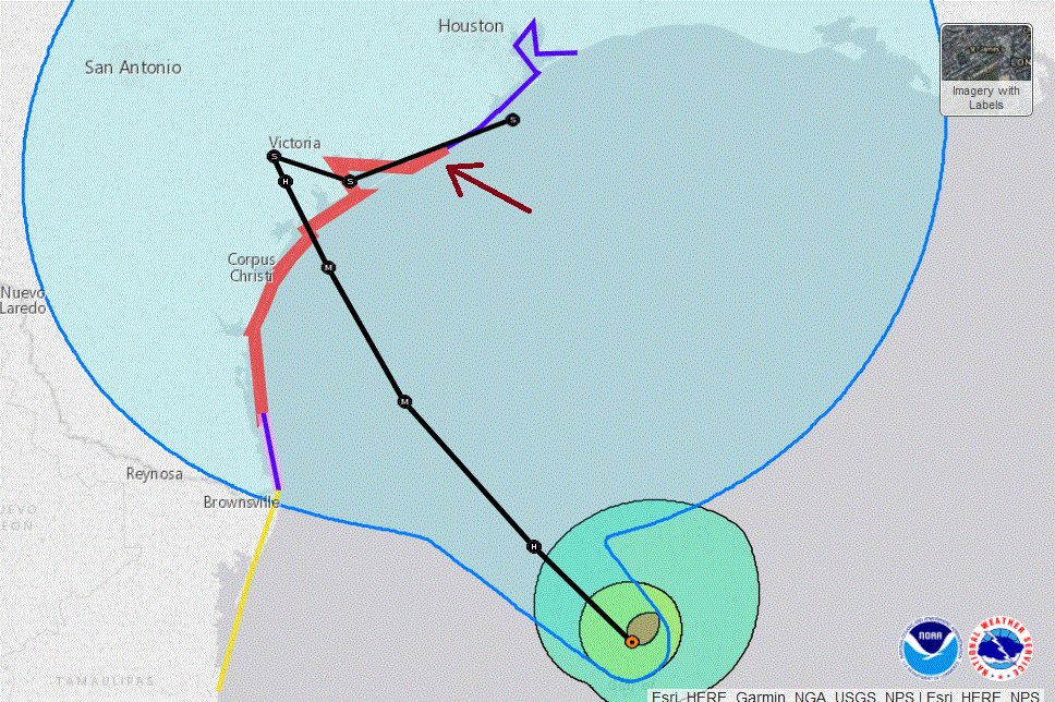
Is Corpus still the center of the cone of totality?

Posted on 8/24/17 at 4:02 pm to tiger91
Posted on 8/24/17 at 4:03 pm to When in Rome
You'll be fine
Posted on 8/24/17 at 4:03 pm to slackster
quote:
36H 26/0600Z 27.8N 96.7W 105 KT 120 MPH
48H 26/1800Z 28.5N 97.1W 85 KT 100 MPH...INLAND
72H 27/1800Z 28.7N 97.2W 45 KT 50 MPH...INLAND
96H 28/1800Z 28.5N 96.5W 35 KT 40 MPH...INLAND
In 60 hours it moves 70 miles inland and comes back out where it started.
Posted on 8/24/17 at 4:04 pm to Dire Wolf
Headed to Houston tmro for a concert. Should be an interesting trip.
Posted on 8/24/17 at 4:04 pm to cgrand
Posted on 8/24/17 at 4:05 pm to Tiger Ryno
So while reading up on historical hurricanes, found this interesting piece of info:
They need to just retire this damn name
quote:
Fastest intensification from a tropical depression to a hurricane (1-minute sustained surface winds) – 12 hours
quote:
Harvey 1981 – 35 mph (55 km/h) to 80 mph (130 km/h) – from 1200 UTC September 12 to 0000 UTC September 13
They need to just retire this damn name
Posted on 8/24/17 at 4:05 pm to When in Rome
quote:
NHC Atlantic Ops @NHC_Atlantic
Hurricane Warning expanded northward along Texas coast to include the area from Matagorda to Sargent. #Harvey LINK
Posted on 8/24/17 at 4:05 pm to When in Rome
Pat Shingleton is just an idiot. He is on the news showing a model run taking this inland in TX and then well into Mexico. Not even showing the models getting this back over water and coming at LA. I understand not wanting to hype something up too much but it seems even more irresponsible to cherry pick the one model (probably their in house model) that shows it going off into Mexico. That's basically telling everyone not to worry because it won't come here. He just says we might get a little rain from feeder bands.
He was doing the same thing yesterday but I let it go because more models were trending west at the time and I felt there was still plenty of time. But now he is doubling down.
He was doing the same thing yesterday but I let it go because more models were trending west at the time and I felt there was still plenty of time. But now he is doubling down.
Posted on 8/24/17 at 4:07 pm to BigB0882
quote:
pick the one model (probably their in house model) that shows it going off into Mexico.
this will not be going into mexico.

Posted on 8/24/17 at 4:08 pm to OldSouth
Anyone new to the area between Austin and San Antonio, stay the hell away from the Guadeloupe, the Blanco, and the Pedernales.
They're flash flood traps.
They're flash flood traps.
Posted on 8/24/17 at 4:08 pm to CptBengal
The PEEJ Model 

Posted on 8/24/17 at 4:09 pm to BigB0882
Par Shingleton has always been an idiot. I liked Mike Graham a lot better when he was on WAFB.
Posted on 8/24/17 at 4:09 pm to CptBengal
quote:
pick the one model (probably their in house model) that shows it going off into Mexico.
this will not be going into mexico.
PJ's prediction guaranteed it wouldn't affect Mexico a week ago.

 Page 114 of 618

Popular
Back to top