- My Forums
- Tiger Rant
- LSU Recruiting
- SEC Rant
- Saints Talk
- Pelicans Talk
- More Sports Board
- Fantasy Sports
- Golf Board
- Soccer Board
- O-T Lounge
- Tech Board
- Home/Garden Board
- Outdoor Board
- Health/Fitness Board
- Movie/TV Board
- Book Board
- Music Board
- Political Talk
- Money Talk
- Fark Board
- Gaming Board
- Travel Board
- Food/Drink Board
- Ticket Exchange
- TD Help Board
Customize My Forums- View All Forums
- Show Left Links
- Topic Sort Options
- Trending Topics
- Recent Topics
- Active Topics
Started By
Message
 0
0

Posted on 3/30/23 at 10:43 am to tide06
quote:
Just like a bad hurricane maybe it’s something that has to impact your life before you can empathize or understand what other people are going through.
It is a whole lot of this.

Posted on 3/30/23 at 10:55 am to rt3
quote:
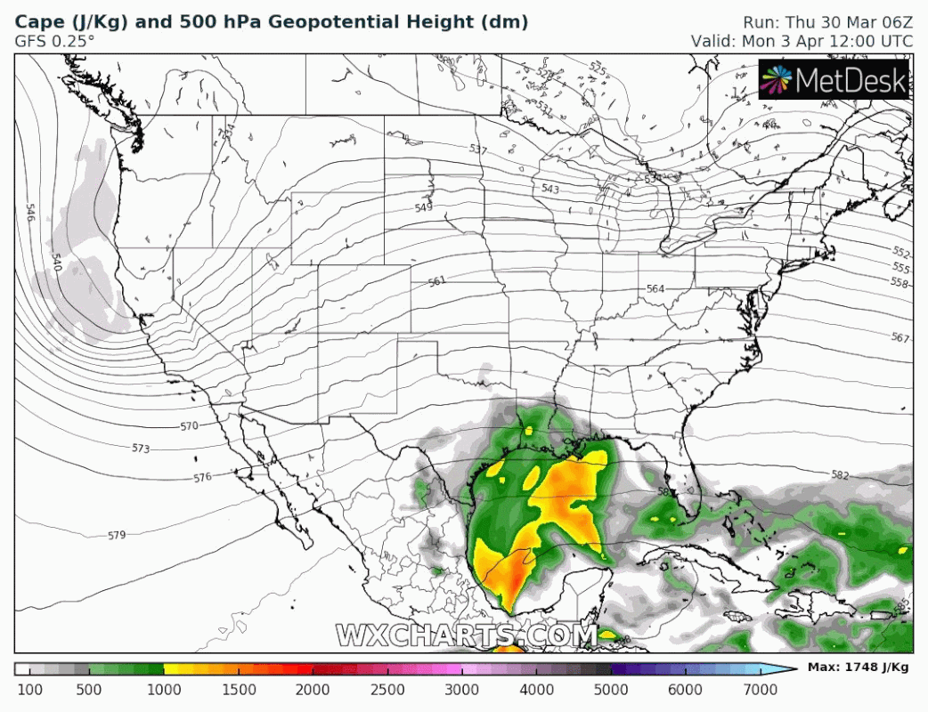
The SPC is already putting out hints of something for the middle of next week
Waayyy early obviously, but CAPE certainly looks sus in that timeframe
Posted on 3/30/23 at 11:03 am to paperwasp
It isn't too hard to believe. The HRRR is throwing 70+ temps, 60+ dews, and 3,000+ MLCAPE all the way to NE Iowa for this week's system.
Posted on 3/30/23 at 1:06 pm to paperwasp
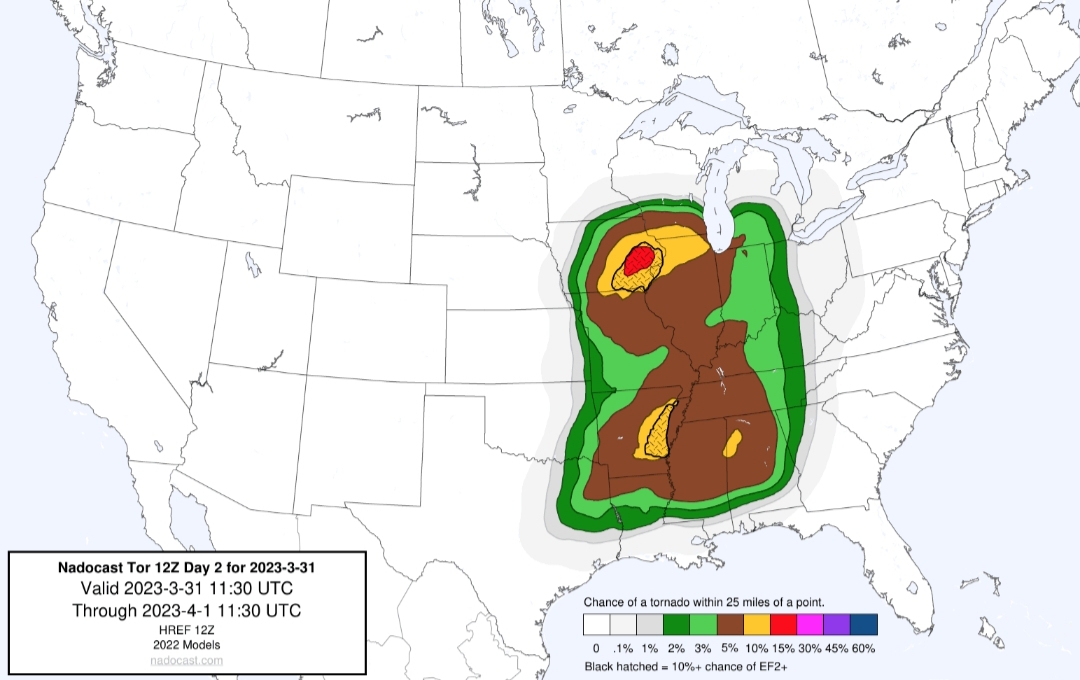
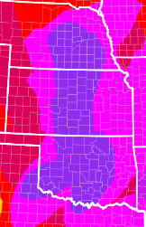
Latest SPC update expanded the Enhanced and the Slight area a bit.
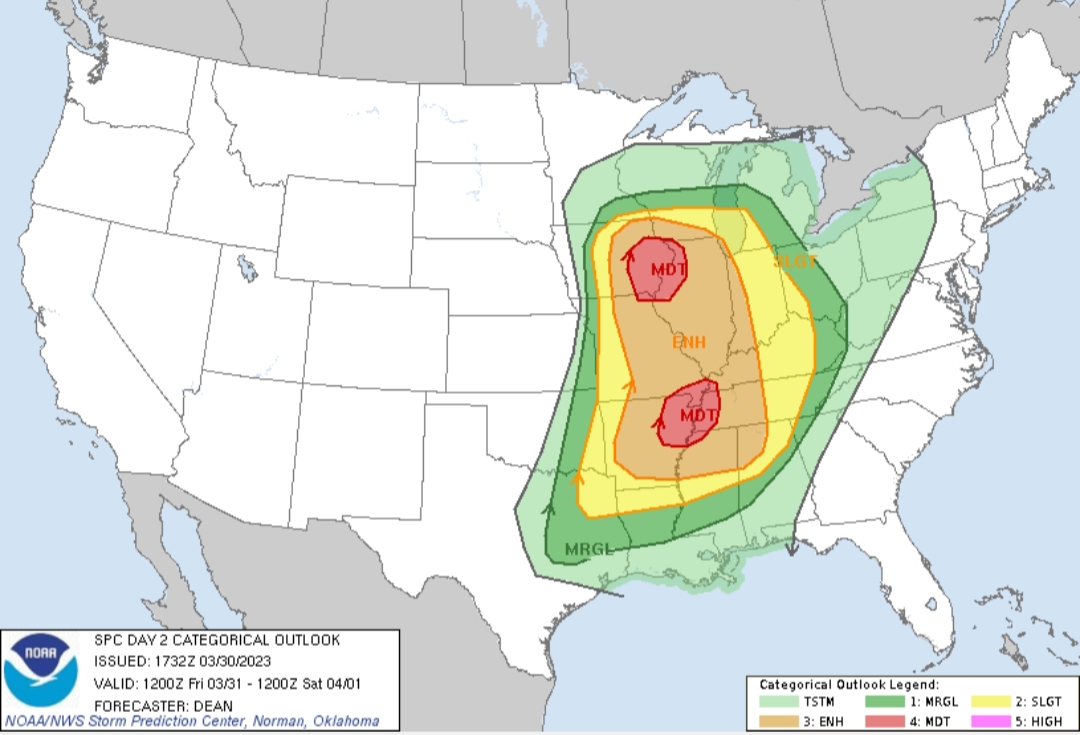
Pretty significant tornado probabilities with this one.
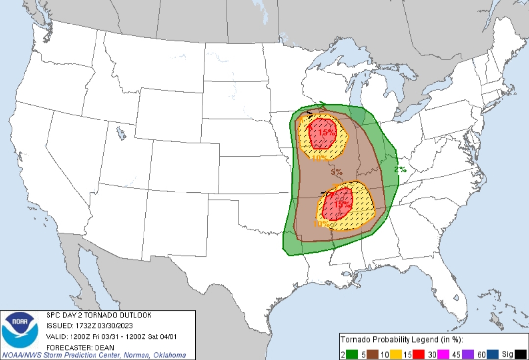
I believe the southern mode has a chance to over perform and stretch beyond the current Enhanced area. It is a question of how far south storms can form along and ahead of the front. Given a decent environment, any storms that form on the tail end of that line will have a chance to cause problems. As usual, don't put too much faith into the borders of the colors on that map.
NE AR and Memphis area folks, start preparing for a significant severe threat beginning around the afternoon rush hour tomorrow. Might not be a terrible idea to knock off at lunch if you can. Being in traffic in that shite won't be fun, whether it is severe or not.
Pretty significant tornado probabilities with this one.
I believe the southern mode has a chance to over perform and stretch beyond the current Enhanced area. It is a question of how far south storms can form along and ahead of the front. Given a decent environment, any storms that form on the tail end of that line will have a chance to cause problems. As usual, don't put too much faith into the borders of the colors on that map.
NE AR and Memphis area folks, start preparing for a significant severe threat beginning around the afternoon rush hour tomorrow. Might not be a terrible idea to knock off at lunch if you can. Being in traffic in that shite won't be fun, whether it is severe or not.
This post was edited on 3/30/23 at 1:07 pm
Posted on 3/30/23 at 1:26 pm to LegendInMyMind
quote:
Pretty significant tornado probabilities
I honestly couldn't remember their actual scale for these, and decided to look it up. Here it is in case anyone else is curious:
quote:
SPC tornado probabilities currently run: 2% (marginal), 5% (slight), 10% (enhanced), 15% (moderate), 30% (high if hatched), 45% (high), 60% (high).
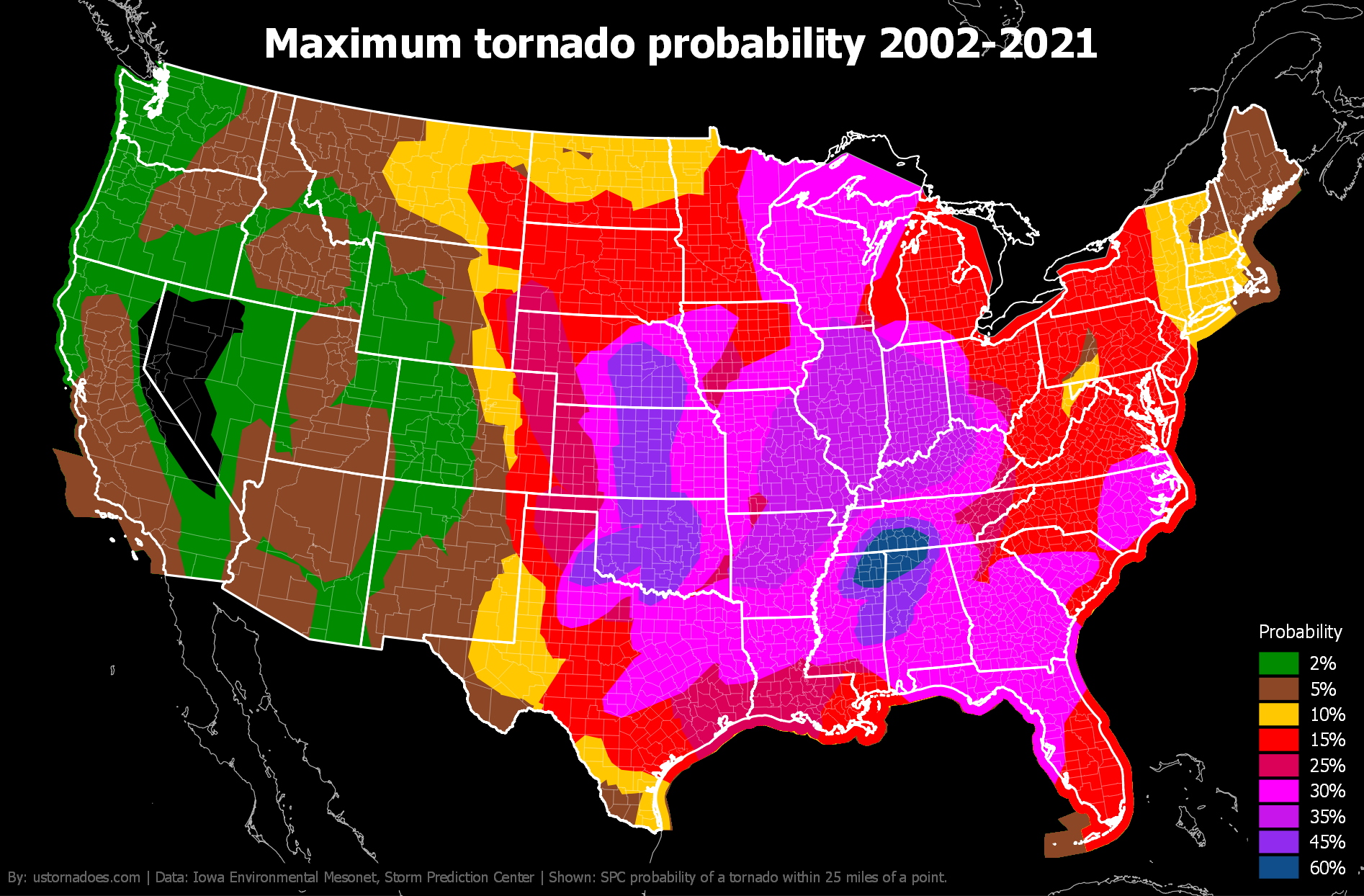
In March of 2022 the maximum tornado probability recorded was 15%.
That often-discussed area in north MS/AL has been taking a beating over the past 20 years.
ETA: Speaking of taking a beating,
inb4

This post was edited on 3/30/23 at 1:33 pm
Posted on 3/30/23 at 2:22 pm to East Coast Band
Updated OP:
quote:
.SUMMARY... Intense and widespread severe thunderstorms are expected Friday afternoon into the overnight hours across portions of the Middle Mississippi Valley and Mid-South vicinity, eastward to the Lower Ohio and Tennessee Valleys. Intense, damaging gusts and several tornadoes (some strong and long-track) are expected. ...A regional outbreak of severe storms is expected on Friday across parts of the Mid-Mississippi Valley and also into the Mid-South...

Posted on 3/30/23 at 2:41 pm to paperwasp
Proud resident of tShaft
Posted on 3/30/23 at 3:31 pm to paperwasp
quote:
@ReedTimmerAccu
I am very concerned about the overall pattern for tornado outbreaks this early spring
Titty milk futures to the moon

Posted on 3/30/23 at 3:38 pm to East Coast Band
Y'all live for this shite

Posted on 3/30/23 at 3:47 pm to HeadSlash
quote:
Y'all live for this shite

Posted on 3/30/23 at 9:51 pm to paperwasp
Extreme northern Louisiana is in a sneaky bad spot for this setup:
Around 3pm tomorrow:
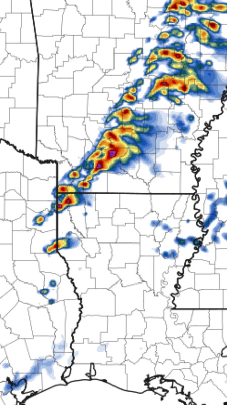
The HRRR has been consistent on firing those tail-end storms. If they happen they will have a pretty good environment for a couple hours. Fortunately, it won't be an extended ordeal as the front will pass pretty quickly, carrying the storms with it.
Just a heads up, as storms forming at the end of what will become that line will have a chance to be rough. Soundings show a decent hail threat with them, as well.
Around 3pm tomorrow:
The HRRR has been consistent on firing those tail-end storms. If they happen they will have a pretty good environment for a couple hours. Fortunately, it won't be an extended ordeal as the front will pass pretty quickly, carrying the storms with it.
Just a heads up, as storms forming at the end of what will become that line will have a chance to be rough. Soundings show a decent hail threat with them, as well.

Posted on 3/31/23 at 5:34 am to HeadSlash
quote:
Y'all live for this shite
You say that like we hope for people to be hit by tornadoes. Weather is inevitable, so we might as well learn about it and discuss it. A lot of us are impacted by many of the severe weather events that we discuss on here, so these threads also help to keep us informed.
This post was edited on 3/31/23 at 5:34 am
Posted on 3/31/23 at 5:43 am to East Coast Band
Ominous wording for the southern moderate risk area (NE Arkansas, western Tennessee vicinity) from SPC this morning:
quote:
...Lower MS Valley...
A secondary corridor of concentrated convection is expected to
evolve ahead of the front across the lower MS Valley. Early-day
mid-level speed max that races across northern OK into MO will allow
the front to surge into southern MO, arcing across the Arklatex by
late afternoon. Surface dew points have risen into the mid 60s
across northeast TX/western LA early this morning. This air mass
will easily advance across AR into western KY prior to convective
initiation. As a result, SBCAPE should be on the order of 2000 J/kg
with very strong sfc-6km shear and low-level SRH. Any supercells
that evolve within this air mass will do so within an environment
that favors long-lived updrafts and strong tornadoes. Upscale growth
into a QLCS is expected during the latter half of the period. Severe
threat should spread east across the northern Gulf States Friday
night.
Posted on 3/31/23 at 6:24 am to Roll Tide Ravens
quote:
SBCAPE should be on the order of 2000 J/kg
I don't know many of the variables in weather, but I think this is very high and very ominous.

Posted on 3/31/23 at 6:40 am to The Boat
quote:
My current job is basically Bill Paxton in that movie
You got any YouTube tornado videos out there? You buds with Reed Timmer who is played by Phillip Seymour Hoffman in that movie.
Posted on 3/31/23 at 7:02 am to East Coast Band
Of course I just bought a house in Indiana without a basement. 


Posted on 3/31/23 at 7:18 am to East Coast Band
NWS decided to post this after one just murdered 6 innocent people in a school shooting
https://mobile.twitter.com/NWS/status/1641774592699035648
quote:
National Weather Service
@NWS
To promote justice, equality, and equity for the transgender community, the National Weather Service family champions and stands alongside our transgender employees on this day and every day! #TransDayOfVisibility

https://mobile.twitter.com/NWS/status/1641774592699035648
Posted on 3/31/23 at 7:22 am to mmcgrath
I’m scheduled to drive from Birmingham to Charleston Saturday morning. Leaving around 5:30am.
I can also leave today around noon if needed.
Is this supposed to be a straight line front moving through or more scattered severe storms? Should I avoid driving Saturday morning?
Seems like I’ll be leaving with the storms and traveling with it across Georgia.
I can also leave today around noon if needed.
Is this supposed to be a straight line front moving through or more scattered severe storms? Should I avoid driving Saturday morning?
Seems like I’ll be leaving with the storms and traveling with it across Georgia.
Posted on 3/31/23 at 7:24 am to Bobby OG Johnson
Love our government offices making clearly divisive political stances.

 Page 3 of 48

Popular
Back to top