- My Forums
- Tiger Rant
- LSU Recruiting
- SEC Rant
- Saints Talk
- Pelicans Talk
- More Sports Board
- Coaching Changes
- Fantasy Sports
- Golf Board
- Soccer Board
- O-T Lounge
- Tech Board
- Home/Garden Board
- Outdoor Board
- Health/Fitness Board
- Movie/TV Board
- Book Board
- Music Board
- Political Talk
- Money Talk
- Fark Board
- Gaming Board
- Travel Board
- Food/Drink Board
- Ticket Exchange
- TD Help Board
Customize My Forums- View All Forums
- Show Left Links
- Topic Sort Options
- Trending Topics
- Recent Topics
- Active Topics
Started By
Message
Posted on 8/30/24 at 8:53 am to Cosmo
its actually great news that the models are showing a direct impact to Louisiana. The models are usually 200-300 miles off this for in advance, that's if this wave even developes.
Posted on 8/30/24 at 8:59 am to Thracken13
quote:
It is not germane to the conversation.
what about the Jackson family, is it fair game?
I was thinking.
The Gawd Damn Germans got nothing to do with it.
This post was edited on 8/30/24 at 9:03 am
Posted on 8/30/24 at 9:00 am to MAXtheTIGER
quote:
Posting single model runs is basically fear porn at this point.
It is, but Louisiana baws have a hard-on for hurricanes and football. Both hit around the same time.
I have no problem with this information being shared because it at least gets people thinking about plans. I will be puling the generator out this weekend to make sure its up to snuff.
Posted on 8/30/24 at 9:49 am to Mr Happy
quote:
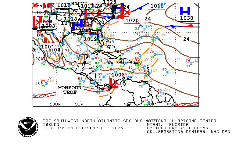
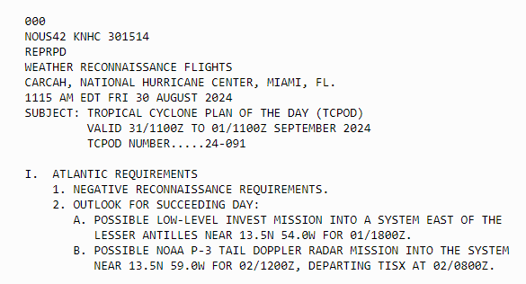
The monsoon trough in the lower right is one of the reasons this is such a tricky forecast. The wave has gotten tangled up in the ITCZ and won't really be able to develop until it breaks free. The models struggle with this setup, but I am surprised that the NHC dropped % from 50 to 40. Not much has changed since yesterday; this will probably be slow to develop, and the slower, the better, as that could force it into Mexico before having a chance to turn north.
Posted on 8/30/24 at 9:55 am to Tarps99
quote:
It is not germane to the conversation.
The goddamn Germans got nothing to do with it
ETA damn I was beat to it
This post was edited on 8/30/24 at 10:03 am
Posted on 8/30/24 at 10:12 am to rds dc
quote:
has gotten tangled up in the ITCZ
I had that happen once. Pulled the hell out of my hamstring.
Posted on 8/30/24 at 10:15 am to rds dc
quote:
The wave has gotten tangled up in the ITCZ
This happened to my uncles leg at work
Gordon got him 500k
Posted on 8/30/24 at 12:15 pm to lsuman25
quote:
Relax that will change. They actually lowered the odds to 40% for this update.
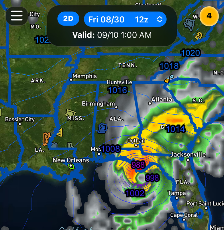
Now Florida is on the board with the GFS 12z…

This post was edited on 8/30/24 at 12:31 pm
Posted on 8/30/24 at 12:53 pm to lsuman25
For the North Atlantic...Caribbean Sea and the Gulf of Mexico:
Northwestern Gulf of Mexico:
A surface trough of low pressure over the northwestern Gulf of
Mexico is producing a large area of disorganized showers and
thunderstorms along and just offshore the coasts of Texas and
Louisiana. This system is expected to meander near the coast
through much of next week, and some slow development is possible if
it remains offshore. Regardless of development, heavy rains could
cause some flash flooding across portions of coastal Louisiana and
the upper Texas coast during the next few days.
* Formation chance through 48 hours...low...10 percent.
* Formation chance through 7 days...low...20 percent.
Posted on 8/30/24 at 1:08 pm to lsuman25
Yeah right along the LATX coast folks could see 10” over next few days
Closer to I10 more like 3-4”
Closer to I10 more like 3-4”
This post was edited on 8/30/24 at 1:09 pm
Posted on 8/30/24 at 1:17 pm to Cosmo
Yep luckily the highest amounts are forecasted to stay over the gulf. Obviously 30-40 miles can mean a lot of inland flooding but hopefully it keeps the bulk over the gulf.
Posted on 8/30/24 at 1:29 pm to Tarps99
quote:
Now Florida is on the board with the GFS 12z…
12z Euro has a hurricane in the Gulf.
Posted on 8/30/24 at 1:30 pm to Cosmo
quote:I need rain so fricking bad right now I'll take it - send some to the Northshore
Yeah right along the LATX coast folks could see 10” over next few days
This post was edited on 8/30/24 at 1:32 pm
Posted on 8/30/24 at 1:47 pm to rds dc
Posted on 8/30/24 at 1:50 pm to rds dc
Overnight this went from a fish storm to a fricking storm in the gulf
Goddamnit
Goddamnit
Posted on 8/30/24 at 1:55 pm to Fun Bunch
I’d say the fish storm option has been gone for a few days. That east coast ridge every model run has become stronger with every run. We need to hope this thing gets buried into Central America
Posted on 8/30/24 at 2:00 pm to Fun Bunch
quote:
Overnight this went from a fish storm to a fricking storm in the gulf
Development before the Islands seems unlikely at this point, which reduces the chances of it fishing. Then, it is hard for storms to organize in the Caribbean, which increases the chances of it reaching the WCAB. Hopefully, the system can't ever get going, and the trades drive it into CA/Mexico.
Popular
Back to top


 0
0


