- My Forums
- Tiger Rant
- LSU Recruiting
- SEC Rant
- Saints Talk
- Pelicans Talk
- More Sports Board
- Fantasy Sports
- Golf Board
- Soccer Board
- O-T Lounge
- Tech Board
- Home/Garden Board
- Outdoor Board
- Health/Fitness Board
- Movie/TV Board
- Book Board
- Music Board
- Political Talk
- Money Talk
- Fark Board
- Gaming Board
- Travel Board
- Food/Drink Board
- Ticket Exchange
- TD Help Board
Customize My Forums- View All Forums
- Show Left Links
- Topic Sort Options
- Trending Topics
- Recent Topics
- Active Topics
Started By
Message


 2
2

Posted on 8/30/24 at 2:30 pm to Tarps99
quote:
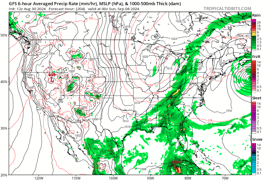
Now Florida is on the board with the GFS 12z…
GFS can GTFO with that
Posted on 8/30/24 at 2:36 pm to LSURoss
Tropics heating up
Posted on 8/30/24 at 2:58 pm to Mr Roboto
quote:
Tropics heating up
The models have been predicting a massive storm end of September / beginning of October for a few weeks now.
Posted on 8/30/24 at 3:10 pm to BayouENGR
This is like 10 days out.
Posted on 8/30/24 at 3:16 pm to GumboPot
that's not ideal
Posted on 8/30/24 at 3:21 pm to rds dc
No.
no. no. no. no. frick off. go away.
no. no. no. no. frick off. go away.
Posted on 8/30/24 at 3:24 pm to TigerBaitOohHaHa
Generator is ready to go.

Posted on 8/30/24 at 3:32 pm to GumboPot
Gonna have to start calling it the Big Bend Over if this keeps up.
Posted on 8/30/24 at 3:33 pm to GumboPot
You would rather be in the cone 10 days out instead of 4 days out

Posted on 8/30/24 at 3:39 pm to PhillyTiger90
quote:
You would rather be in the cone 10 days out instead of 4 days out
Which is precisely why Louisiana needs to watch out for this.
Until the next run puts a cat 5 into New Orleans. Then Texas needs to watch out.
Until the following run throws a tropical storm into North Carolina. That’s when Miami better pucker up.
This post was edited on 8/30/24 at 3:40 pm
Posted on 8/30/24 at 3:44 pm to tide06
quote:
The models have been predicting a massive storm end of September / beginning of October for a few weeks now.
Which ones. Show me what models predict hurricanes over a month out
Posted on 8/30/24 at 3:45 pm to PhillyTiger90
quote:
You would rather be in the cone 10 days out instead of 4 days out
The cone is from Mexico to Cuba so the whole gulf is in it currently
Posted on 8/30/24 at 3:52 pm to rds dc
Buying my hurricane snacks now
Posted on 8/30/24 at 4:01 pm to tide06
quote:
he models have been predicting a massive storm end of September / beginning of October for a few weeks now
Link? What models predict storms over a month out?!
Posted on 8/30/24 at 4:17 pm to Midtiger farm
There are models that predict atmospheric convection/lift that far out.
It’s not a guarantee that a storm will actually occur, but it does indicate that there’s a likelihood that the conditions will be right for development.
Here’s a picture of what it looks like, it’s been showing this at the end of the month for weeks:
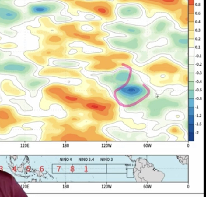
Blue is lift and it tracks on the graph based on latitude meaning this is showing lift in the gulf for the end of the month.
It’s not a guarantee that a storm will actually occur, but it does indicate that there’s a likelihood that the conditions will be right for development.
Here’s a picture of what it looks like, it’s been showing this at the end of the month for weeks:
Blue is lift and it tracks on the graph based on latitude meaning this is showing lift in the gulf for the end of the month.
This post was edited on 8/30/24 at 4:22 pm
Posted on 8/30/24 at 4:20 pm to tide06
quote:
There are models that predict atmospheric convection/lift that far out.
It’s not a guarantee that a storm will take place but it is a likelihood that the conditions will be right for development.
So its wasn't predicting a huge storm like you claimed in your previous post
Also those aren't always accurate - that mjo model was predicting the conditions would be right from Aug 15th on and it was wrong and the storm is forming next week not at the end of the month and not even in the MDR
Posted on 8/30/24 at 4:24 pm to Midtiger farm
quote:
So its wasn't predicting a huge storm like you claimed in your previous post
It’s predicting the conditions will be conducive for a huge storm to occur.
Whether it does or doesn’t occur depends on a myriad of other factors.
Posted on 8/30/24 at 4:30 pm to tide06
quote:
It’s predicting the conditions will be conducive for a huge storm to occur.
No it isn't - its predicting conditions for tropical development to occur
that model has nothing to do with intensity or size
Posted on 8/30/24 at 4:53 pm to Midtiger farm
quote:
that model has nothing to do with intensity or size
It’s indicating the intensity of the predicted convection. The darker the blue the higher the convection.
Can we agree that there’s a direct correlation between convection and potential storm intensity?
I agree that I should’ve changed my wording. It’s not directly predicting a strong storm, but rather that one of the strongest indicators for storm development and intensification is present. Taken in conjunction with historically high water temps in the gulf it’s something to be concerned about.

 Page 8 of 492

Popular
Back to top