- My Forums
- Tiger Rant
- LSU Recruiting
- SEC Rant
- Saints Talk
- Pelicans Talk
- More Sports Board
- Fantasy Sports
- Golf Board
- Soccer Board
- O-T Lounge
- Tech Board
- Home/Garden Board
- Outdoor Board
- Health/Fitness Board
- Movie/TV Board
- Book Board
- Music Board
- Political Talk
- Money Talk
- Fark Board
- Gaming Board
- Travel Board
- Food/Drink Board
- Ticket Exchange
- TD Help Board
Customize My Forums- View All Forums
- Show Left Links
- Topic Sort Options
- Trending Topics
- Recent Topics
- Active Topics
Started By
Message
 0
0

Posted on 9/8/24 at 12:31 pm to friendlyobservation
quote:
and how they stalled out.
Fortunately this one seems like it will move through quick? Hopefully given the short time frame any development will be compact and move through quick.
Posted on 9/8/24 at 12:31 pm to maisweh
quote:
You wish casted Ida with that tree
Ida got rid of all my trees thankfully.
Yard is still a little wet, but I am elevated about 3 feet above ground level.
So barring a massive failure in the South Lafourche levee system I should be good even if water floods the yard.
Posted on 9/8/24 at 12:31 pm to stout
quote:
Yeah but a lot of developments have gone up in 8 years changing drainage.
I've been giving this reality a lot of thought lately.
A couple weeks or so ago parts of Connecticut saw catastrophic flooding comparable to their floods of record. I was watching a few videos and reading some posts on X. Quite a few people were saying that they were seeing areas flood that had never flooded before. When you started really looking at the areas on the videos, they were mostly full of new developments, with plenty of commercial development. Every building or home that goes up and every parking lot that is laid down changes how water travels.
I started to understand that with areas that have seen large development over the years you can't really compare floods like that. Everything we do, or don't do in regards to maintenance of drainages and such, has an impact. Drawing comparison between what floods today and what flooded even just 15-20 years ago isn't of much use.
This post was edited on 9/8/24 at 12:33 pm
Posted on 9/8/24 at 12:39 pm to LegendInMyMind
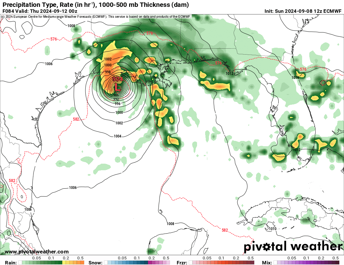
Welp, there it is.....Euro run....

Posted on 9/8/24 at 12:39 pm to ned nederlander
only one model, gefs now showing heaving flooding as steering falls apart once inland
recon in the air, so we should know a lot
more later today
recon in the air, so we should know a lot
more later today
This post was edited on 9/8/24 at 12:42 pm

Posted on 9/8/24 at 12:40 pm to lsugolfredman
TITS OUT

Posted on 9/8/24 at 12:40 pm to lsugolfredman
quote:
Welp, there it is.....Euro run....
Cat 2 into Vermillion Bay?

Posted on 9/8/24 at 12:43 pm to lsugolfredman
Welp, that’s pretty close to the GFS and much stronger than the previous run.
I’ll refrain from speculating what could happen during a hurricane, though. Wouldn’t want to “wishcast”.
I’ll refrain from speculating what could happen during a hurricane, though. Wouldn’t want to “wishcast”.
Posted on 9/8/24 at 12:46 pm to lsugolfredman
Yikes
Posted on 9/8/24 at 12:47 pm to lsugolfredman
Less than 4 days. If these runs are consistent tomorrow gonna be a shite show at stores tomorrow here in Louisiana
Posted on 9/8/24 at 12:47 pm to TDsngumbo
I would say this might catch people by surprise tonight, but I thinj everyone still living south of I-10 posts in this thread.

Posted on 9/8/24 at 12:48 pm to TDsngumbo
Well hell that looks pretty awful for SELA
Posted on 9/8/24 at 12:52 pm to Impotent Waffle
Whelp folks, it appears it is time to break out the bingo cards and start thawing the Breast milk
Posted on 9/8/24 at 12:53 pm to Impotent Waffle
Will we see a PTC Advisory with a cone later today?
Posted on 9/8/24 at 12:53 pm to lsuman25
Ugh
Posted on 9/8/24 at 12:54 pm to Impotent Waffle
quote:
start thawing the Breast milk
Why would you thaw it?
Shouldn’t you be freezing it so it lasts longer?

Posted on 9/8/24 at 12:56 pm to lsuman25
Consensus in the models.... 
Tonight we will know more once the hurricane hunter data is put in.
Tonight we will know more once the hurricane hunter data is put in.
Posted on 9/8/24 at 12:56 pm to lsuman25
Western Gulf of Mexico (AL91):
An elongated area of low pressure located over the southwestern Gulf
of Mexico continues to produce a large area of showers and
thunderstorms. Satellite-derived winds show this system does not yet
have a well-defined center, but is producing winds of 40 to 45 mph
on its western side. Environmental conditions appear conducive for
additional development and a tropical storm is expected to form
during the next day or so. The system is forecast to move generally
northwestward and then northward near or along the Gulf coast of
Mexico, upper Texas, and Louisiana coasts with additional
strengthening possible by the middle of this week.
Interests along the Gulf coast of Mexico, upper Texas, and Louisiana
coasts should closely monitor the progress of this system. Tropical
Storm Watches could be required for portions of the coast of
northeastern Mexico and southern Texas later this afternoon or
tonight, with additional watches possible along the coast of Texas
and Louisiana later tonight or Monday. An Air-Force Reserve
Hurricane Hunter aircraft is currently in route to to investigate
the system this afternoon. Additional information on this system,
including gale warnings, can be found in High Seas Forecasts issued
by the National Weather Service.
* Formation chance through 48 hours...high...90 percent.
* Formation chance through 7 days...high...90 percent.
Posted on 9/8/24 at 12:56 pm to lsuman25
Guess I'll start preparing now. Was kinda hoping it would end up weaker by landfall.

 Page 38 of 492

Popular
Back to top