- My Forums
- Tiger Rant
- LSU Recruiting
- SEC Rant
- Saints Talk
- Pelicans Talk
- More Sports Board
- Fantasy Sports
- Golf Board
- Soccer Board
- O-T Lounge
- Tech Board
- Home/Garden Board
- Outdoor Board
- Health/Fitness Board
- Movie/TV Board
- Book Board
- Music Board
- Political Talk
- Money Talk
- Fark Board
- Gaming Board
- Travel Board
- Food/Drink Board
- Ticket Exchange
- TD Help Board
Customize My Forums- View All Forums
- Show Left Links
- Topic Sort Options
- Trending Topics
- Recent Topics
- Active Topics
Started By
Message
re: Francine - Landfall in Terrebonne Parish as CAT 2 100 mph
Posted on 9/11/24 at 8:00 am to terd ferguson

Posted on 9/11/24 at 8:00 am to terd ferguson
quote:
I gotta poop but don't feel like getting out of bed
You've got a wife to clean it. Don't see the problem. Relax and do your business.
 1
1

Posted on 9/11/24 at 8:00 am to pwejr88
quote:
Nola with a 12:00 pm curfew
So now one’s allowed to be out in the middle of the day?

Posted on 9/11/24 at 8:00 am to m57
quote:
The difference between the models that WDSU and Fox 8 are using is astounding. WDSU has the worst basically over Gonzalez while Fox 8 has Metry/Nola getting the worst.
That's because Zack Fradella is at Fox 8. I love him but he's transitioned into a big hype meteorologist. He's good at what he does and I get it, he's trying to warn the NOLA area not to let their guard down because the high resolution models have continued to show this going into NOLA but it's like he's ignoring the NHC forecast altogether.
Personally, I can't wait to see who ends up being correct - NHC or the GRAF and other high resolution models.
Posted on 9/11/24 at 8:01 am to ragincajun03
quote:
So now one’s allowed to be out in the middle of the day?
That's just good safe practice in NOLA on a regular day.
Posted on 9/11/24 at 8:02 am to Mr. Hangover
quote:
My bad. I just hate this kinda shite. Nerves are in overdrive today
Just stay safe!
Posted on 9/11/24 at 8:02 am to 3HourTour
Don’t tell me what to do!

Posted on 9/11/24 at 8:02 am to TDsngumbo
quote:
Mesoscale Discussion
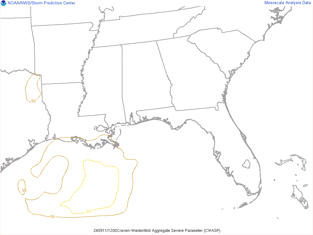
Craven-Wiedenfeld Aggregate Severe Parameter (CWASP)
This aggregate parameter is the sum of 33 individual weighted parameters, ranging from mandatory pressure level winds, temperature and moisture, to CAPE and vertical shear. Typical ranges of values were established for each parameter in association with significant tornado (EF2+) events, and a numerical weight of 0-3 was assigned to each parameter. If all parameters are consistent with historical EF2+ tornado events, the CWASP total will reach a maximum value of 99. The majority of EF2+ tornadoes have occurred with CWASP values above about 70.
Note: This is a BETA value. Just thought it was interesting that the same (southeastern Louisiana coastal) areas affected in the discussion are also starting to be highlighted here, which represents an aggregate of various conditions.
Be careful today, friends.
Posted on 9/11/24 at 8:03 am to MikeD
quote:
Let’s be honest, the track has shifted east by half almost half the state in the days leading up to landfall
The track has shifted ~80 miles since the storm formed, which is within their average error over 60 hours.
Before it was even a storm they issued an early warning that was near the state line - a warning designed to give people more time to prep since the storm didn’t actually form for another 18 hours - and people want to say they blew it. If they waited to issue something until they had an actual center then people wouldn’t have heard about this thing until Monday morning.
Posted on 9/11/24 at 8:03 am to Mr. Hangover
Lots of really strong winds showing up WELL to the east of the center per recon.
Posted on 9/11/24 at 8:03 am to m57
The local covington nws forecast went from 40 gusts last night to 62, now back down to 44, without the official track changing.
Posted on 9/11/24 at 8:03 am to tigerskin
And? What’s your point? They are. We are.

Posted on 9/11/24 at 8:03 am to LSUBFA83
quote:
right over my house
Yep, the line overlays my youngest’s house and mine.
Very little doubt about losing power, usually a wet sneeze knocks us out.

Posted on 9/11/24 at 8:04 am to Festus
Now we know why begf won't marry you.
Could y'all just find the nearest blue shed and ride out this storm safely please.
Could y'all just find the nearest blue shed and ride out this storm safely please.

Posted on 9/11/24 at 8:04 am to terd ferguson
quote:
I gotta poop but don't feel like getting out of bed
We call that pulling an Entergy
Posted on 9/11/24 at 8:05 am to Old Man and a Porch
quote:
So what does one of the knowledgeable posters say? Duke, rsd? New Orleans or the NHC track?

New Orleans is along the NHC track.
ETA: New Orleans is going to be impacted along the NHC track. If the storm goes over Hammond New Orleans gets impacted just as much as it does if it’s 15-20 miles west.
This post was edited on 9/11/24 at 8:10 am

Posted on 9/11/24 at 8:05 am to MikeD
quote:
Let’s be honest, the track has shifted east by half almost half the state in the days leading up to landfall
The track has shifted a total of 30 miles since the center formed.
Working on some morning thoughts right now.
Posted on 9/11/24 at 8:06 am to terd ferguson
quote:
terd ferguson
quote:
I gotta poop
Checks out.

Posted on 9/11/24 at 8:09 am to The Boat
Morgan City like I said a few days ago.
Hopefully, for us, it does not take the Fox8 turn they have been talking about.
Hopefully, for us, it does not take the Fox8 turn they have been talking about.

Posted on 9/11/24 at 8:10 am to paperwasp
A three year-old trying to draw a Pac Man…

quote:
Posted on 9/11/24 at 8:11 am to paperwasp
quote:
This aggregate parameter is the sum of 33 individual weighted parameters, ranging from mandatory pressure level winds, temperature and moisture, to CAPE and vertical shear. Typical ranges of values were established for each parameter in association with significant tornado (EF2+) events, and a numerical weight of 0-3 was assigned to each parameter. If all parameters are consistent with historical EF2+ tornado events, the CWASP total will reach a maximum value of 99. The majority of EF2+ tornadoes have occurred with CWASP values above about 70.
Wtf does all this mean

 Page 302 of 492

Popular
Back to top