- My Forums
- Tiger Rant
- LSU Recruiting
- SEC Rant
- Saints Talk
- Pelicans Talk
- More Sports Board
- Fantasy Sports
- Golf Board
- Soccer Board
- O-T Lounge
- Tech Board
- Home/Garden Board
- Outdoor Board
- Health/Fitness Board
- Movie/TV Board
- Book Board
- Music Board
- Political Talk
- Money Talk
- Fark Board
- Gaming Board
- Travel Board
- Food/Drink Board
- Ticket Exchange
- TD Help Board
Customize My Forums- View All Forums
- Show Left Links
- Topic Sort Options
- Trending Topics
- Recent Topics
- Active Topics
Started By
Message
 0
0

Posted on 10/6/20 at 3:36 pm to GumboPot
quote:
The storm will be way too inland for a cat 2 storm 120 hours from now. The range of intensity models from the SHIP to the CTCI is a lot more realistic.
You'd normally be correct, but Delta will be hauling arse and wind field degradation wont be nearly as quick.

Posted on 10/6/20 at 3:38 pm to lsugolfredman
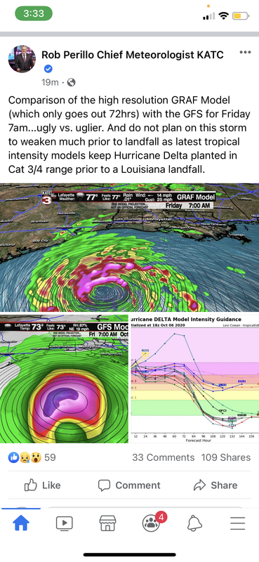
DAMN U ROB PARILLO
Posted on 10/6/20 at 3:38 pm to sealawyer
quote:
quote:
Wondering why global models don't seem to be aware of #Delta's current intensity? Tomer does an awesome job explaining. The storm is too small to be properly "seen" by global models with large grid spacing. This is a case where it's *much* better to stick to HWRF/HMON!
HWRF and HMON have two of the more eastward tracks on the latest ensemble, shown above
I'm not sure that is as big of an issue once the system gets into the Gulf as land interaction and EWRC will cause the storm to get larger. This is why we are seeing more realistic depictions of the system in the Gulf. Ultimately, the only global with the resolution to compete with the hi-res hurricane models is the Euro but it's done a poor job this season. Also, ensembles are run at a lower resolution and even less useful for intensity.
Ultimately, globals aren't great for intensity but they are usually close enough with the vertical structure to determine the primary drivers for steering. The 12z runs see a favorable environment for strengthening in the Gulf but there has been little change in the steering setup.
Posted on 10/6/20 at 3:39 pm to rds dc


Posted on 10/6/20 at 3:39 pm to jimbeam
Do fast moving hurricanes have more storm surge than the slower moving ones relative to their strength? Or is it a combo of size? Or is this one of those it depends questions like most. Sorry for being curious and dumb
Posted on 10/6/20 at 3:40 pm to lsugolfredman
frick man. Keeps shifting West. Man I pray for those people in LC and Iowa.
Posted on 10/6/20 at 3:40 pm to lsugolfredman
quote:
...EXTREMELY DANGEROUS CATEGORY FOUR HURRICANE DELTA HEADING
TOWARD THE NORTHEASTERN COAST OF THE YUCATAN PENINSULA...
...EXPECTED TO BRING A LIFE-THREATENING STORM SURGE AND EXTREME
WINDS...
SUMMARY OF 500 PM EDT...2100 UTC...INFORMATION
----------------------------------------------
LOCATION...18.9N 84.1W
ABOUT 215 MI...345 KM ESE OF COZUMEL MEXICO
ABOUT 240 MI...385 KM ESE OF TULUM MEXICO
MAXIMUM SUSTAINED WINDS...145 MPH...230 KM/H
PRESENT MOVEMENT...WNW OR 300 DEGREES AT 17 MPH...28 KM/H
MINIMUM CENTRAL PRESSURE...956 MB...28.23 INCHES
Bumped up a bit.
This post was edited on 10/6/20 at 3:41 pm

Posted on 10/6/20 at 3:41 pm to Uncle JackD
This is horrible
I literally JUST put out my Halloween decorations.
I literally JUST put out my Halloween decorations.

Posted on 10/6/20 at 3:41 pm to Uncle JackD
DAT GOTT DANG ROB PERILLO

Posted on 10/6/20 at 3:41 pm to Ash Williams
Keep on trucking west. All the way past LC.
Posted on 10/6/20 at 3:41 pm to tgrbaitn08
That isn’t a new track. That’s the 2pm one
Posted on 10/6/20 at 3:42 pm to Duke
I'd like to hear your expert evaluation of the "EEMN" projected path in the diagram below... 


Posted on 10/6/20 at 3:42 pm to Ash Williams
Sorry to hear that.
What did you go with, some of that spider web stuff?
What did you go with, some of that spider web stuff?

Posted on 10/6/20 at 3:42 pm to TigahFan4Life
Steve Caparotta, Ph.D.
@SteveWAFB
·
5m
JUST IN: 4 PM update on #Delta shows max winds now up to 145 mph. Forecast track nudged a little westward at landfall in Louisiana. South Louisiana residents should be prepared for potential Cat 2/3 hurricane landfall by late Friday. #L

Posted on 10/6/20 at 3:43 pm to MorbidTheClown
Are you fricking kidding me
Posted on 10/6/20 at 3:43 pm to TigahFan4Life
quote:
That isn’t a new track. That’s the 2pm one
Check the first page, it auto updates

Posted on 10/6/20 at 3:43 pm to jimbeam
Right through Lafa-yette

Posted on 10/6/20 at 3:44 pm to fightin tigers
quote:
Check the first page, it auto updates

Posted on 10/6/20 at 3:44 pm to MorbidTheClown
Will be interesting to see if the westward trend continues once it gets into the Gulf

 Page 126 of 601

Popular
Back to top