- My Forums
- Tiger Rant
- LSU Recruiting
- SEC Rant
- Saints Talk
- Pelicans Talk
- More Sports Board
- Coaching Changes
- Fantasy Sports
- Golf Board
- Soccer Board
- O-T Lounge
- Tech Board
- Home/Garden Board
- Outdoor Board
- Health/Fitness Board
- Movie/TV Board
- Book Board
- Music Board
- Political Talk
- Money Talk
- Fark Board
- Gaming Board
- Travel Board
- Food/Drink Board
- Ticket Exchange
- TD Help Board
Customize My Forums- View All Forums
- Show Left Links
- Topic Sort Options
- Trending Topics
- Recent Topics
- Active Topics
Started By
Message
re: Beta - Downgraded to TD - Now Short Break in Storms or Season Over?
Posted on 9/18/20 at 9:46 am to LSUFanHouston
Posted on 9/18/20 at 9:46 am to LSUFanHouston
quote:
I thought Alphas had a plan, and went directly to a place?
They do what they want.
 0
0

Posted on 9/18/20 at 9:53 am to Cosmo

Posted on 9/18/20 at 10:01 am to LegendInMyMind
quote:

You're not the only one now.

Posted on 9/18/20 at 10:08 am to rt3
In the TD22 discussion from NHC...
2020 y'all
quote:
It should be noted that the Air Force Reserve Hurricane Hunter aircraft that was scheduled to investigate the depression had to turn back after getting hit by lightning.
2020 y'all
This post was edited on 9/18/20 at 10:09 am
Posted on 9/18/20 at 10:10 am to LSUFanHouston
quote:
It should be noted that the Air Force Reserve Hurricane Hunter aircraft that was scheduled to investigate the depression had to turn back after getting hit by lightning.
Trump’s fault.
Posted on 9/18/20 at 10:14 am to rt3
@jacksillin
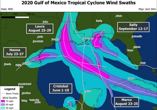
quote:
It's been a very busy year for tropical cyclone activity in the Gulf of Mexico!
Between Cristobal, Hanna, Laura, Marco, and Sally, most of the Gulf has seen winds of at least tropical storm-force.
The most notable gap is the southwestern Gulf which should get filled in by #TD22
This post was edited on 9/18/20 at 10:18 am

Posted on 9/18/20 at 10:16 am to rds dc
quote:

God I miss 130s!
I’d have given my left nut to work on the hurricane hunters.
This post was edited on 9/18/20 at 10:49 am

Posted on 9/18/20 at 10:21 am to BallsEleven
Looked it up and saw this will only be the second Alpha ever.
quote:
Tropical Storm Alpha was the twenty-third named storm of the record-breaking 2005 Atlantic hurricane season. Since the 21 names from the predetermined A–W list were all used, Alpha was the first tropical storm ever to be given a name from the Greek alphabet.
Posted on 9/18/20 at 10:57 am to Who_Dat_Tiger
Pretty sure it’ll be Wilfred
Unless something else in the Atlantic stole it which would be peak 2020
Unless something else in the Atlantic stole it which would be peak 2020
Posted on 9/18/20 at 10:58 am to PhillyTiger90
quote:
Pretty sure it’ll be Wilfred
Wilfred already exists.

Posted on 9/18/20 at 10:59 am to Duke
With this storm's predicted indecisiveness, the name Beta would have been more appropriate.
Posted on 9/18/20 at 11:07 am to Jwho77
NHC trying to be funny or something?
quote:
Tropical Storm Wilfred
...WILFRED FORMS IN THE EASTERN TROPICAL ATLANTIC... ...GET OUT THE GREEK ALPHABET FOR THE REST OF 2020...
Posted on 9/18/20 at 11:07 am to Duke
Thanks Duke
I just gave myself a downvote
I just gave myself a downvote

Posted on 9/18/20 at 11:09 am to rt3
quote:
In the event that more than twenty-one named tropical cyclones occur in the Atlantic basin in a season, additional storms will take names from the Greek alphabet. This naming convention has been established by the World Meteorological Organization Tropical Cyclone Programme.
Posted on 9/18/20 at 11:12 am to PhillyTiger90
quote:
Pretty sure it’ll be Wilfred
Unless something else in the Atlantic stole it which would be peak 2020
also peak 2020 when it comes to tropical systems... it steals a name and just fizzles out (if only those bitches Laura & Sally had done the same thing)
quote:
000
WTNT43 KNHC 181435
TCDAT3
Tropical Storm Wilfred Discussion Number 1
NWS National Hurricane Center Miami FL AL232020
1100 AM AST Fri Sep 18 2020
Satellite images indicate that the broad area of low pressure over
the eastern Atlantic has become better-defined this morning. In
addition, scatterometer data also show a closed circulation, albeit
with some rain contamination causing some noise near the center.
The initial wind speed is set to 35 kt, in accordance with
scatterometer data from last night (this morning's data missed the
eastern side of the storm). Thus Wilfred has formed, continuing
the record-setting pace of the 2020 hurricane season since it is
the earliest 21st named storm on record, about 3 weeks earlier
than Vince of 2005.
Further intensification is possible during the next day or two
before a large upper-level trough is forecast to drop into the
path of the storm and stay there for at least a few days. That
should promote weakening due to a substantial increase in shear, and
most of the global models show this tropical cyclone opening up
into a trough by day 5. The official forecast follows this
scenario, and the NHC intensity forecast is a blend of the
consensus and corrected-consensus aids.
Wilfred is moving west-northwestward at about 15 kt. The storm
is forecast to continue this motion for the next several days,
owing to steering from the low- to middle-level subtropical ridge.
The guidance is in fair agreement, and the official forecast is
near or west of the consensus at all times, leaning in the
direction of the HCCA corrected-consensus. I should mention that
if Wilfred intensifies more than expected, it would probably move a
bit right of the forecast track for a while due to the expected
southwesterly flow at higher levels, before eventually turning back
west-northwestward.
FORECAST POSITIONS AND MAX WINDS
INIT 18/1500Z 11.9N 32.4W 35 KT 40 MPH
12H 19/0000Z 12.6N 34.6W 40 KT 45 MPH
24H 19/1200Z 13.5N 37.5W 40 KT 45 MPH
36H 20/0000Z 14.5N 40.2W 40 KT 45 MPH
48H 20/1200Z 15.6N 42.8W 35 KT 40 MPH
60H 21/0000Z 16.7N 45.5W 30 KT 35 MPH
72H 21/1200Z 17.3N 47.5W 30 KT 35 MPH
96H 22/1200Z 18.0N 50.0W 25 KT 30 MPH...POST-TROP/REMNT LOW
120H 23/1200Z...DISSIPATED
$$
Forecaster Blake
Posted on 9/18/20 at 11:14 am to LSUJML
quote:
In the event that more than twenty-one named tropical cyclones occur in the Atlantic basin in a season, additional storms will take names from the Greek alphabet. This naming convention has been established by the World Meteorological Organization Tropical Cyclone Programme.
oh I know that JML... just saying the met who wrote that headline on Wilfred JUST HAS TO POINT OUT we're already out of regular names
Posted on 9/18/20 at 11:14 am to PhillyTiger90
To be fair, it's a TS by the strictest definition only.
Posted on 9/18/20 at 11:15 am to rt3


Posted on 9/18/20 at 11:18 am to lsugolfredman
That’s too much rain for me.

Posted on 9/18/20 at 11:19 am to lsugolfredman
That sucks!

 Page 21 of 63

Popular
Back to top