- My Forums
- Tiger Rant
- LSU Recruiting
- SEC Rant
- Saints Talk
- Pelicans Talk
- More Sports Board
- Coaching Changes
- Fantasy Sports
- Golf Board
- Soccer Board
- O-T Lounge
- Tech Board
- Home/Garden Board
- Outdoor Board
- Health/Fitness Board
- Movie/TV Board
- Book Board
- Music Board
- Political Talk
- Money Talk
- Fark Board
- Gaming Board
- Travel Board
- Food/Drink Board
- Ticket Exchange
- TD Help Board
Customize My Forums- View All Forums
- Show Left Links
- Topic Sort Options
- Trending Topics
- Recent Topics
- Active Topics
Started By
Message

 0
0


Posted on 9/16/20 at 6:07 pm to Who_Dat_Tiger
quote:
So there really is a shield around SELA this hurricane season
We borrowed the Barksdale bubble from Bossier City
Posted on 9/16/20 at 6:32 pm to jmarto1
quote:
So there really is a shield around SELA this hurricane season
I don’t know but we sure have been lucky.
My biggest fear as a resident of the Bayou area is a storm like this: you have a storm that forms in the southwestern gulf and moves in a north northeast direction. It would constantly be pushing water up the bayou areas until it the center passes 90 degrees west longitude, and winds shift to the northwest.
On the converse when you have a storm tracking from the South East, you have a northern winds that will blow out most of the water at first, but once the center crosses 90 degrees longitude the winds start shifting to the south and push water in. Also, the Mississippi River Ridge helps funnel the most of the surge into lake Ponchatrain when you have East to west storms. You don’t have this protection from a storm coming from the west.
Opal comes to mind as one that came close to the west to East scenario. She missed Louisiana and went to Florida.
This post was edited on 9/16/20 at 6:46 pm
Posted on 9/16/20 at 6:57 pm to Who_Dat_Tiger
quote:
So there really is a shield around SELA this hurricane season
It is the nets ducks unlimited puts up north to keep the ducks from flying south, but it also interrupts the wind currents and prevents hurricanes from moving north....win some , loose some?

Posted on 9/16/20 at 8:01 pm to rds dc
Screw this hurricane season. And this year. I want to hit FFwd on 2020 and restart somewhere around mid-December. Election will be over (DJT bigly), playoff football will be kicking off, Christmas will be a week or so away, and 2021 will be around the corner. Oh, and the pandemic will have ended a month or so before that.
Posted on 9/16/20 at 9:37 pm to rds dc
Looks like the Hellen Keller cone/forecast
Posted on 9/16/20 at 9:56 pm to Duke
quote:
The GFS is pretty close to having that big trough catch Teddy but that was a wild 12z run for the Euro. Catches Teddy and then slings it at Maine around the ULL up there. Makes a huge trough complex in the east coast to bring up the gulf system.
What's weird is the EPS version of this kind of shows the same thing. Been paying attention to Sally and didn't notice the silly season projected for the Atlantic pattern.
ETA: The Euro did nail ...
Levi has a good video out tonight that goes into the Teddy stuff - LINK
One thing he didn't mention, that will play out over the next couple of days, is how the outflow from the convection associated with Sally will interact with the jet associated with the incoming northern stream trough. That will modulate the jet and play a role in the wave break over Greenland and that will go into determining if the orientation of the trough/ridge is such that the trough can cutoff and slingshot Teddy. So while 90L may be a week away before making it's move, we can watch how the convection from Sally influences the northern stream trough over the next few days to get some hints as to what model might be handling all this better.
And after looking at things a bit more, that outflow also plays a role in the 1st cutoff that Teddy will encounter out over the Atlantic. So, relatively short term convective trends, that the global models struggle with, will play a big role in how things evolve over the next week with impacts on Teddy and future 90L.

Posted on 9/16/20 at 10:00 pm to rds dc
Yay more complex setups
Posted on 9/16/20 at 10:02 pm to rds dc
Jesus what does that all mean besides it’s 2020 and shite coming off of Greenland is steering Teddy
Posted on 9/16/20 at 10:08 pm to rds dc
So basically ignore all models for the next few days?
Posted on 9/16/20 at 10:25 pm to lsuman25
quote:
Yay more complex setups

Posted on 9/16/20 at 10:26 pm to rds dc
Yeah, exactly what I was thinking.....
Posted on 9/16/20 at 10:30 pm to Dizz
quote:
So basically ignore all models for the next few days?
The skinny is the models will struggle with how Sally's energy will effect the things that steer Teddy which effect what happens to 90L too. So the things we will be paying attention to on the models aren't so much where they send a storm but how the short term predictions are matching reality because it will suggest which model is handling the complexities better.
Interesting process for me to watch at least.
Posted on 9/17/20 at 12:42 am to Tarps99
All of this has made me re-evaluate what I will stick around for. There is just a point that riding it out isn't worth it
Posted on 9/17/20 at 12:54 am to Duke
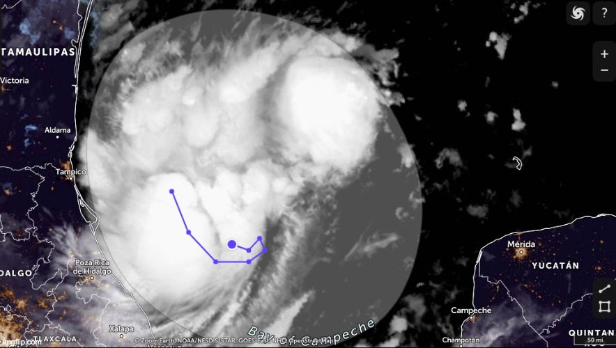
Thunderstorm activity associated with a low pressure system located
over the southwestern Gulf of Mexico has increased in coverage and
organization this morning. In addition, recent satellite-derived
surface wind data indicate that the low has become better defined.
Upper-level winds are expected to gradually become more conducive
for development, and a tropical depression is likely to form during
the next day or so while the low meanders over the southwestern Gulf
of Mexico. An Air Force Reserve reconnaissance aircraft is scheduled
to investigate the disturbance later today, if necessary.
* Formation chance through 48 hours...high...70 percent.
* Formation chance through 5 days...high...90 percent.
Posted on 9/17/20 at 1:01 am to rds dc
quote:
One thing he didn't mention, that will play out over the next couple of days, is how the outflow from the convection associated with Sally will interact with the jet associated with the incoming northern stream trough. That will modulate the jet and play a role in the wave break over Greenland and that will go into determining if the orientation of the trough/ridge is such that the trough can cutoff and slingshot Teddy. So while 90L may be a week away before making it's move, we can watch how the convection from Sally influences the northern stream trough over the next few days to get some hints as to what model might be handling all this better.
And after looking at things a bit more, that outflow also plays a role in the 1st cutoff that Teddy will encounter out over the Atlantic. So, relatively short term convective trends, that the global models struggle with, will play a big role in how things evolve over the next week with impacts on Teddy and future 90L.
You beat me to it
Posted on 9/17/20 at 5:14 am to lsuman25
Those recon planes are getting a workout this year.

Posted on 9/17/20 at 5:50 am to rds dc
I love it when a plan comes together. 
Posted on 9/17/20 at 6:35 am to Armymann50
Thunderstorm activity has continued to increase and become better
organized this morning in association with a well-defined low
pressure system located over the southwestern Gulf of Mexico.
Upper-level winds are gradually becoming more conducive for
development and, if this recent development trend continues, a
tropical depression or a tropical storm could form later today. The
low is expected to meander over the southwestern Gulf of Mexico for
the next day or so before moving slowly northward to northeastward
on Friday and Saturday. An Air Force Reserve reconnaissance
aircraft is scheduled to investigate the disturbance this afternoon.
* Formation chance through 48 hours...high...90 percent.
* Formation chance through 5 days...high...90 percent.

Posted on 9/17/20 at 6:43 am to lsuman25

 Page 10 of 63

Back to top