- My Forums
- Tiger Rant
- LSU Recruiting
- SEC Rant
- Saints Talk
- Pelicans Talk
- More Sports Board
- Fantasy Sports
- Golf Board
- Soccer Board
- O-T Lounge
- Tech Board
- Home/Garden Board
- Outdoor Board
- Health/Fitness Board
- Movie/TV Board
- Book Board
- Music Board
- Political Talk
- Money Talk
- Fark Board
- Gaming Board
- Travel Board
- Food/Drink Board
- Ticket Exchange
- TD Help Board
Customize My Forums- View All Forums
- Show Left Links
- Topic Sort Options
- Trending Topics
- Recent Topics
- Active Topics
Started By
Message
re: Deep South Severe Weather Thread (Enhanced)
Posted on 10/24/21 at 9:04 pm to Roll Tide Ravens

Posted on 10/24/21 at 9:04 pm to Roll Tide Ravens
quote:
@RadarOmega
There are now THREE PDS TORNADO WARNINGS in effect for areas of Missouri and Illinois! These are confirmed LARGE and EXTREMELY DANGEROUS tornadoes! This is a life threatening situation! Seek shelter NOW! #MOwx #ILwx
quote:
A particularly dangerous situation (PDS) tag is enhanced wording first used by the Storm Prediction Center (SPC), a national guidance center of the United States National Weather Service, for tornado watches and eventually expanded to use for other severe weather watches and warnings by local NWS forecast offices. It is issued at the discretion of the forecaster composing the watch or warning and implies that there is an enhanced risk of very severe and life-threatening weather, usually a major tornado outbreak or a long-lived, extreme derecho event, but possibly another weather hazard such as an exceptional flash flood or fire.[1][2]
PDS watches are quite uncommon; less than 3% of watches issued by the SPC from 1996 to 2005 were PDS watches, or an average of 24 each year.[3] When a PDS watch is issued, there are often more PDS watches issued for the same weather system, even on the same day during major outbreaks, so the number of days per year that a PDS watch is issued is significantly lower.
quote:When was the last time there were three simultaneous PDS warnings?
PDS tornado warnings are currently issued on an experimental basis by the 38 National Weather Service Weather Forecast Offices within the Central Region.[15] The criteria for a PDS warning are when a tornado on the ground has been spotted or confirmed, or a significant tornado is expected based on radar signatures. While the intention of this experimental warning may be to replace the loosely defined tornado emergency, PDS tornado warnings are structured as the second highest level of tornado warning within the impact based warning system (an experiment – which also includes tags within warning products illustrating radar indications or physical observations of tornadoes, and damage potential – participated by the 33 Weather Forecast Offices within the Central Region, as well as eight additional offices within the Western, Eastern and Southern regions that began utilizing the system in the spring of 2014[16]); a tornado emergency, the highest warning level, is used within the United States for destructive tornadoes approaching more densely populated areas. These are the first warnings issued with PDS wording, and like PDS flash flood watches, are issued by local forecast offices.[17][18]
This post was edited on 10/24/21 at 9:06 pm
 0
0


Posted on 10/24/21 at 9:05 pm to LegendInMyMind
quote:
Got a link, or just a channel name?
KFVS-12 (CBS)
WSIL 3 (ABC)
KBSI Fox 23
My bad
Posted on 10/24/21 at 9:07 pm to Pisco
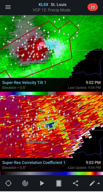
KFVS 12 is following it closely. I live about an hour south of Fredericktown. Ours is supposed to come through around midnight-1am. Perfect timing.
Posted on 10/24/21 at 9:10 pm to BootheelSoldier
Likely debris fallout:
Posted on 10/24/21 at 9:11 pm to BootheelSoldier
I’m here in Mayfield, KY. Ours is coming late as well. I’m watching KFVS as well. Fox and WSIL also are covering

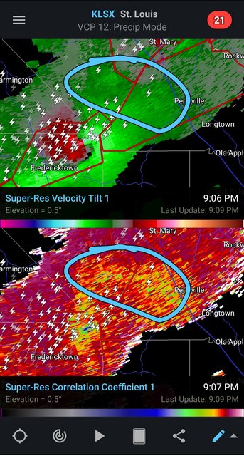
Posted on 10/24/21 at 9:12 pm to Roll Tide Ravens
The lead storm is back to having a confirmed tornado.
Posted on 10/24/21 at 9:15 pm to Roll Tide Ravens

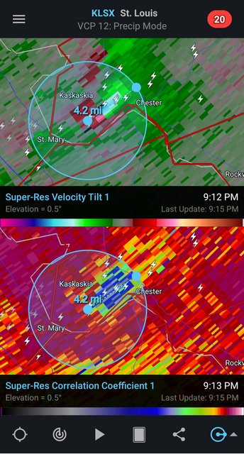
Posted on 10/24/21 at 9:15 pm to Roll Tide Ravens
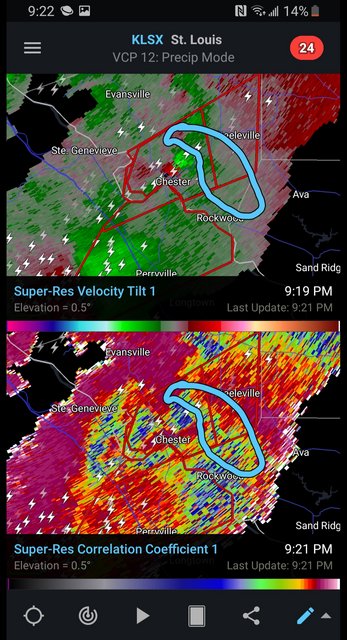
The Chester tornado TDS is over 4 miles wide.
Posted on 10/24/21 at 9:15 pm to Pisco
We just had a tornado back in July so hoping to miss this round. Fingers crossed

Posted on 10/24/21 at 9:17 pm to LegendInMyMind

Posted on 10/24/21 at 9:19 pm to Bobby OG Johnson
Confirmed catastrophic damage. I didn't catch which storm it is, though.
Posted on 10/24/21 at 9:20 pm to LegendInMyMind
More debris fallout on radar with the TDS nearing five miles wide. Good grief!

Posted on 10/24/21 at 9:21 pm to LegendInMyMind
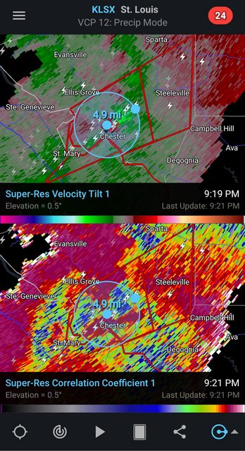
Chester tornado is a monster
Posted on 10/24/21 at 9:22 pm to LegendInMyMind
The TDS on the storm that went through Fredericktown is not as deep as earlier, but it is roughly 5 miles wide.
Posted on 10/24/21 at 9:24 pm to The Boat
quote:
Chester tornado is a monster
Yes, it is.
Posted on 10/24/21 at 9:25 pm to Roll Tide Ravens
quote:
The TDS on the storm that went through Fredericktown is not as deep as earlier, but it is roughly 5 miles wide.
That one probably isn’t on the ground anymore. The rotation is really broad. You can compare the difference to the tight rotation of the Chester cell.
Posted on 10/24/21 at 9:30 pm to The Boat
That Chester tornado is playing tricks. It is likely still on the ground. Tight couplet, lofted debris is cluttering a clear look at the TDS.

 Page 4 of 23

Popular
Back to top