- My Forums
- Tiger Rant
- LSU Recruiting
- SEC Rant
- Saints Talk
- Pelicans Talk
- More Sports Board
- Fantasy Sports
- Golf Board
- Soccer Board
- O-T Lounge
- Tech Board
- Home/Garden Board
- Outdoor Board
- Health/Fitness Board
- Movie/TV Board
- Book Board
- Music Board
- Political Talk
- Money Talk
- Fark Board
- Gaming Board
- Travel Board
- Food/Drink Board
- Ticket Exchange
- TD Help Board
Customize My Forums- View All Forums
- Show Left Links
- Topic Sort Options
- Trending Topics
- Recent Topics
- Active Topics
Started By
Message
 0
0

Posted on 10/25/21 at 7:26 pm to Roll Tide Ravens
That South Boston , VA tornado not far from my old stomping grounds.
Posted on 10/25/21 at 7:39 pm to Roll Tide Ravens
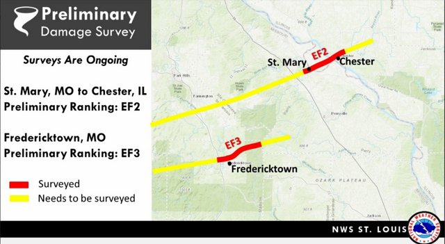
NWS St. Louis confirmed two tornadoes so far and their preliminary damage survey showed EF2 and EF3 damage:
I've said before that we have a whole lot to learn about debris on radar. I believe radar capability has progressed much faster than our understanding of it. I would love to see these two tornadoes lead to research into debris signatures and radar presentation of Correlation Coefficient during tornadic storms during the Fall.
Thinking over the amount if debris fallout that was clear in both of those tornadoes, not just the TDS, but the fallout as what was lofted descended to the ground, I believe leaves and other vegetation could be part of the radar presentation we saw. The way it was scattered gave more of a signature than we usually see. Dry fall leaves and other dry/dead vegetation weighs less than green vegetation like we see in the Spring. It could very well be lofted higher and kept aloft longer to be distributed over a greater distance. Hopefully, last night's tornadoes lead to some good research.
Posted on 10/25/21 at 7:42 pm to East Coast Band
It had a pretty good couplet off and on. You could see the Meso really take off with couple of big bursts of lightning.

Posted on 10/26/21 at 6:29 pm to LegendInMyMind
Any updates on this? Or nothing to worry about
Posted on 10/26/21 at 7:29 pm to red sox fan 13
Ummm nothing to worry about. Ground might get a little wet. Move on.
Posted on 10/26/21 at 9:37 pm to red sox fan 13
quote:
Any updates on this? Or nothing to worry about
Watching for storms in front of squall line tomorrow for tornado potential in the high shear environment. Squall line could be a little extra spicy but doesnt look like a widespread big deal.
Posted on 10/26/21 at 10:19 pm to Duke
quote:
Squall line could be a little extra spicy but doesnt look like a widespread big deal.
Gone B bout 10 tuh 15 minutes fuh da extra spicy squaw line…you wonna wait? K baby pull up fuh me

Posted on 10/26/21 at 11:45 pm to Duke
Someone remind me… when you see the front start to bow out, that’s when we can expect high winds? Watching the radar for this line that’s going to move through overnight and seeing a real bow forming out front.

Posted on 10/27/21 at 1:19 am to LSUGrrrl
It’s ok. Im still wondering how Trump Denial Syndrome (TDS) and Rural Free Delivery (RFD) have anything to do with a tornado.
And if MESO is supposed to be a flat-top geologic mountain formation that creates tornados as well.
The showing off of industry acronyms make this stupidly hard to follow what’s going on.
And watch for that hook! Might duck and weave before you counter punch.
And if MESO is supposed to be a flat-top geologic mountain formation that creates tornados as well.
The showing off of industry acronyms make this stupidly hard to follow what’s going on.
And watch for that hook! Might duck and weave before you counter punch.
Posted on 10/27/21 at 1:35 am to LSUGrrrl
quote:
Someone remind me… when you see the front start to bow out, that’s when we can expect high winds
It’s not 100% but generally yes
Posted on 10/27/21 at 5:15 am to Wishnitwas1998
Seems to be a bit upgraded now. Find when they project this it’s usually nothing, but random storms kick our arse. Hope it’s the same.
Posted on 10/27/21 at 7:17 am to Kay
HRRR seems to be doing a good job right now on timing, and shows discrete cells developing in the designated enhanced risk area
Posted on 10/27/21 at 8:22 am to DVinBR
Tornado warning for Houston
Tornado watch includes Lake Charles, Lafayette, & Alexandria
Tornado watch includes Lake Charles, Lafayette, & Alexandria
Posted on 10/27/21 at 8:44 am to rt3
Storms are starting to rotate near the Houston area and they are under a slight risk. As the storms move into Acadiana around 1-4pm look for more severe storms that produce tornados as the line moves into the Enhanced risk area. Keep an eye to the sky

Posted on 10/27/21 at 8:47 am to purple18
but will they close the schools?!? 
Posted on 10/27/21 at 8:49 am to purple18
10% tornado probability and hatched area for possible strong tornadoes only happens a few days a year in Louisiana - especially in south Louisiana. Stay safe out there.

Also 30% chance of damaging winds - just what areas recovering from Ida really need

Also 30% chance of damaging winds - just what areas recovering from Ida really need
This post was edited on 10/27/21 at 8:55 am

Posted on 10/27/21 at 8:51 am to NorthEndZone
Here is the current tornado watch:

There have already been several tornado warnings this morning in SE Texas.
There have already been several tornado warnings this morning in SE Texas.
Posted on 10/27/21 at 8:54 am to Roll Tide Ravens
quote:
Meteorologist Nick Mikulas
Lots to talk about, so I’ll skip the fun stuff. A tornado watch has been issued for a large part of the area until 4:00 PM. SPC has increased the tornado risk to 10% in our area, and thrown in a “hatched area”. That means there is a 10% chance for a strong tornado of EF 2 or greater strength within 25 miles of a point. The main issue is that we are seeing isolated supercells develop ahead of the main line. This is what we don’t want. I’ve heard the great James Spann say that the first storms of the day will “talk to you”. In today’s case, there are now tornado warnings along the main line, and one tornado warning on a supercell ahead of the main line. That tells me we are looking at a busy day, as it should get worse through the morning and into the early afternoon. I’m not sure on my plan for the day, but I’ll probably end up on the road at some point. I’ll keep you posted.
Posted on 10/27/21 at 8:55 am to Roll Tide Ravens
Current tornado warning for the Port Arthur area:


 Page 6 of 23

Popular
Back to top