- My Forums
- Tiger Rant
- LSU Recruiting
- SEC Rant
- Saints Talk
- Pelicans Talk
- More Sports Board
- Fantasy Sports
- Golf Board
- Soccer Board
- O-T Lounge
- Tech Board
- Home/Garden Board
- Outdoor Board
- Health/Fitness Board
- Movie/TV Board
- Book Board
- Music Board
- Political Talk
- Money Talk
- Fark Board
- Gaming Board
- Travel Board
- Food/Drink Board
- Ticket Exchange
- TD Help Board
Customize My Forums- View All Forums
- Show Left Links
- Topic Sort Options
- Trending Topics
- Recent Topics
- Active Topics
Started By
Message
 1
1

Posted on 10/5/17 at 9:39 pm to Geaux Team Geaux
Hope and Pray- Coach Zero

Posted on 10/5/17 at 9:49 pm to ShermanTxTiger
Is the 10 pm out yet. Should see a little bit of a track shift. 

Posted on 10/5/17 at 9:53 pm to The Boat
Did some stocking up tonight on booze and basics. Just heard Cantore is in Mississippi so hopefully he knows something we don't. 

Posted on 10/5/17 at 9:53 pm to The Boat
Fox8 says a tad more west which is a big suck for us.
frick hurricanes!
frick hurricanes!

Posted on 10/5/17 at 9:55 pm to t00f
I just got storm surge and hurricane watch alerts on my phone
Posted on 10/5/17 at 9:56 pm to lsuwontonwrap
Posted on 10/5/17 at 9:56 pm to t00f
000
WTNT41 KNHC 060251
TCDAT1
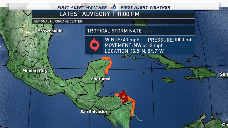
Tropical Storm Nate Discussion Number 7
NWS National Hurricane Center Miami FL AL162017
1100 PM EDT Thu Oct 05 2017
Nate's center has been moving northwestward across eastern
Honduras, but it is just about to reach the waters of the
northwestern Caribbean Sea. Despite moving over land for the past
12-15 hours, the cyclone appears to have a relatively intact and
well-defined inner core. Deep convection has actually been
increasing over the center, and recent 85-GHz microwave data showed
at least some form of a convective ring. Given these signs, the
maximum winds are being held at 35 kt. An Air Force Reserve
Hurricane Hunter aircraft will be investigating Nate during the next
several hours to get a better handle on the storm's intensity and
structure.
Nate has been moving northwestward while crossing Nicaragua and
Honduras, and the initial motion estimate is 325/10 kt. The storm
is currently embedded within a broad Central American gyre, and it
should swing north-northwestward on the east side of this gyre
during the next 36 hours. After 36 hours, Nate should turn
northward and then northeastward along the western periphery of a
mid-tropospheric high centered off the southeastern U.S. coastline.
Compared to yesterday at this time, the track models have come into
much better agreement, and all the reliable models take Nate's
center across the northeastern portion of the Yucatan peninsula in
24 hours and then across the U.S. central Gulf coast between 48 and
60 hours. Because of this tight clustering, there are no notable
cross-track changes in the NHC forecast. Speed-wise, however, the
updated official forecast is a bit faster than the previous one and
has caught up to the various consensus aids.
Due to low shear and very high oceanic heat content in the
northwestern Caribbean Sea, Nate should at least steadily
strengthen once it moves offshore, especially since it appears to
have a well-defined inner core. Rapid intensification is still not
out of the question, and Nate could be near hurricane intensity by
the time it reaches the Yucatan coast in about 24 hours. Land
interaction with the Yucatan peninsula could cause a brief hiatus in
the strengthening trend, but conditions should be conducive for
additional intensification while Nate is over the Gulf of Mexico.
Overall, the intensity models have not changed much on this cycle,
and the NHC forecast still calls for a 48-hour intensity of 70 kt,
which is at the upper end of the guidance between HWRF and HCCA.
As mentioned before, Nate could strengthen further in the time
between the 48-hour position and when it crosses the U.S. Gulf
coast.
KEY MESSAGES:
1. Heavy rainfall is the main threat from Nate in portions of
Central America, with life-threatening flash flooding and mud slides
possible in portions of Nicaragua, Honduras, Costa Rica, Panama, and
Belize through Friday night.
2. Nate could be near hurricane intensity when it approaches the
Yucatan Peninsula late Friday, bringing direct impacts from wind,
storm surge, and heavy rainfall. A tropical storm warning and a
hurricane watch are in effect for a portion of this area, and
life-threatening flash flooding is also possible.
3. Nate is forecast to reach the northern Gulf Coast this weekend as
a hurricane, and the threat of direct impacts from wind, storm
surge, and heavy rainfall is increasing from Louisiana through the
western Florida Panhandle. Hurricane and tropical storm watches, as
well as a storm surge watch, have been issued for a portion of the
northern Gulf Coast, and residents in these areas should monitor the
progress of Nate, heeding any advice given by local officials.
FORECAST POSITIONS AND MAX WINDS
INIT 06/0300Z 15.8N 84.7W 35 KT 40 MPH...INLAND
12H 06/1200Z 17.8N 85.6W 40 KT 45 MPH...OVER WATER
24H 07/0000Z 20.8N 87.1W 50 KT 60 MPH...INLAND
36H 07/1200Z 24.3N 89.1W 60 KT 70 MPH...OVER WATER
48H 08/0000Z 27.5N 90.2W 70 KT 80 MPH
72H 09/0000Z 33.7N 87.9W 45 KT 50 MPH...INLAND
96H 10/0000Z 40.0N 79.0W 25 KT 30 MPH...POST-TROP/REMNT LOW
120H 11/0000Z 43.0N 68.0W 25 KT 30 MPH...POST-TROP/REMNT LOW
$$
Forecaster Berg
WTNT41 KNHC 060251
TCDAT1
Tropical Storm Nate Discussion Number 7
NWS National Hurricane Center Miami FL AL162017
1100 PM EDT Thu Oct 05 2017
Nate's center has been moving northwestward across eastern
Honduras, but it is just about to reach the waters of the
northwestern Caribbean Sea. Despite moving over land for the past
12-15 hours, the cyclone appears to have a relatively intact and
well-defined inner core. Deep convection has actually been
increasing over the center, and recent 85-GHz microwave data showed
at least some form of a convective ring. Given these signs, the
maximum winds are being held at 35 kt. An Air Force Reserve
Hurricane Hunter aircraft will be investigating Nate during the next
several hours to get a better handle on the storm's intensity and
structure.
Nate has been moving northwestward while crossing Nicaragua and
Honduras, and the initial motion estimate is 325/10 kt. The storm
is currently embedded within a broad Central American gyre, and it
should swing north-northwestward on the east side of this gyre
during the next 36 hours. After 36 hours, Nate should turn
northward and then northeastward along the western periphery of a
mid-tropospheric high centered off the southeastern U.S. coastline.
Compared to yesterday at this time, the track models have come into
much better agreement, and all the reliable models take Nate's
center across the northeastern portion of the Yucatan peninsula in
24 hours and then across the U.S. central Gulf coast between 48 and
60 hours. Because of this tight clustering, there are no notable
cross-track changes in the NHC forecast. Speed-wise, however, the
updated official forecast is a bit faster than the previous one and
has caught up to the various consensus aids.
Due to low shear and very high oceanic heat content in the
northwestern Caribbean Sea, Nate should at least steadily
strengthen once it moves offshore, especially since it appears to
have a well-defined inner core. Rapid intensification is still not
out of the question, and Nate could be near hurricane intensity by
the time it reaches the Yucatan coast in about 24 hours. Land
interaction with the Yucatan peninsula could cause a brief hiatus in
the strengthening trend, but conditions should be conducive for
additional intensification while Nate is over the Gulf of Mexico.
Overall, the intensity models have not changed much on this cycle,
and the NHC forecast still calls for a 48-hour intensity of 70 kt,
which is at the upper end of the guidance between HWRF and HCCA.
As mentioned before, Nate could strengthen further in the time
between the 48-hour position and when it crosses the U.S. Gulf
coast.
KEY MESSAGES:
1. Heavy rainfall is the main threat from Nate in portions of
Central America, with life-threatening flash flooding and mud slides
possible in portions of Nicaragua, Honduras, Costa Rica, Panama, and
Belize through Friday night.
2. Nate could be near hurricane intensity when it approaches the
Yucatan Peninsula late Friday, bringing direct impacts from wind,
storm surge, and heavy rainfall. A tropical storm warning and a
hurricane watch are in effect for a portion of this area, and
life-threatening flash flooding is also possible.
3. Nate is forecast to reach the northern Gulf Coast this weekend as
a hurricane, and the threat of direct impacts from wind, storm
surge, and heavy rainfall is increasing from Louisiana through the
western Florida Panhandle. Hurricane and tropical storm watches, as
well as a storm surge watch, have been issued for a portion of the
northern Gulf Coast, and residents in these areas should monitor the
progress of Nate, heeding any advice given by local officials.
FORECAST POSITIONS AND MAX WINDS
INIT 06/0300Z 15.8N 84.7W 35 KT 40 MPH...INLAND
12H 06/1200Z 17.8N 85.6W 40 KT 45 MPH...OVER WATER
24H 07/0000Z 20.8N 87.1W 50 KT 60 MPH...INLAND
36H 07/1200Z 24.3N 89.1W 60 KT 70 MPH...OVER WATER
48H 08/0000Z 27.5N 90.2W 70 KT 80 MPH
72H 09/0000Z 33.7N 87.9W 45 KT 50 MPH...INLAND
96H 10/0000Z 40.0N 79.0W 25 KT 30 MPH...POST-TROP/REMNT LOW
120H 11/0000Z 43.0N 68.0W 25 KT 30 MPH...POST-TROP/REMNT LOW
$$
Forecaster Berg

Posted on 10/5/17 at 9:57 pm to The Boat
quote:
Is the 10 pm out yet.
quote:
Posted by The Boat online on 10/5/17 at 9:49
Busted your nut 11 min early mon frere.
Posted on 10/5/17 at 9:57 pm to lsuman25
so Nate is going to get back into the water here in the next few hours
Posted on 10/5/17 at 9:57 pm to beerJeep
Hurricane and TS watches for LA now
Posted on 10/5/17 at 9:57 pm to Muriel
Hurricane watch now in effect

Posted on 10/5/17 at 9:57 pm to beerJeep
quote:
Busted your nut 11 min early mon frere.
They usually release the advisories about 10 minutes before the top of the hour, rookie.
Posted on 10/5/17 at 9:59 pm to Muriel
I bet they'll be extending the hurricane watch west to Intracoastal City by the end of tomorrow.
Posted on 10/5/17 at 9:59 pm to The Boat

Posted on 10/5/17 at 9:59 pm to The Boat
quote:
They usually release the advisories about 10 minutes before the top of the hour
So it's a 9:50 update and not a 10:00 update

Posted on 10/5/17 at 10:03 pm to geauxtigers87
quote:
I just got storm surge and hurricane watch alerts on my phone
Me to and I live across the bay from Mobile. Guess AT&T is sending them out to anyone that lives on the Gulf Coast. There is a strong north wind blowing here just like when Irma hit Florida. Wouldn't be surprised if Nate drifted more west than the so called experts on TV are saying.
Posted on 10/5/17 at 10:03 pm to lsuwontonwrap
He flew into Gpt this afternoon. He wouldn't say where he is setting up yet. Having drinks in Biloxi tonight.
Posted on 10/5/17 at 10:04 pm to rds dc
The cone looks so much smaller than normal, but the scale of the maps has to be much smaller in order to fit the entire 3 day cone. It's a crazy illusion.

 Page 65 of 193

Popular
Back to top